
-
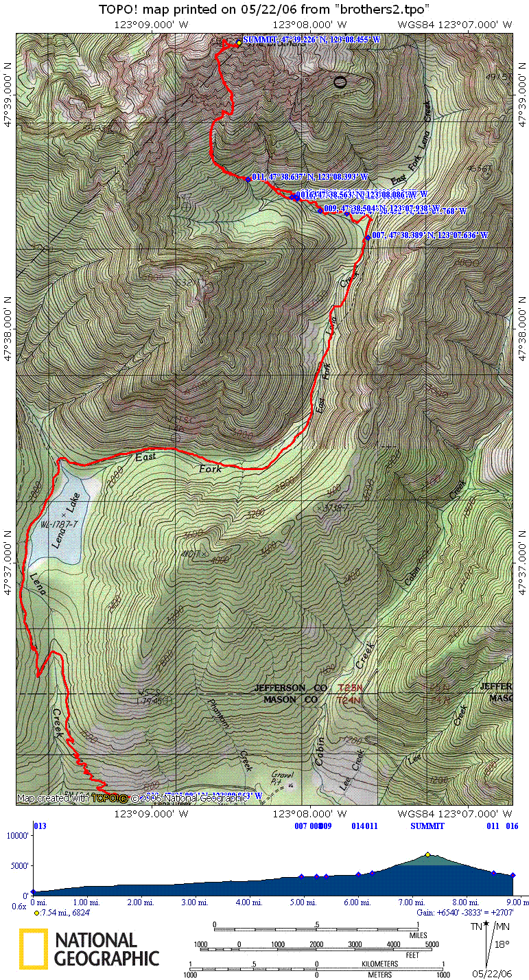
 116439 Hits
-
 90.01% Score
-
 31 Votes
|
|
Mountain/Rock |
|---|---|
|
|
47.65375°N / 123.14062°W |
|
|
Download GPX » View Route on Map |
|
|
Jefferson |
|
|
Hiking, Mountaineering, Scrambling, Skiing |
|
|
Spring, Summer, Fall, Winter |
|
|
6842 ft / 2085 m |
|
|
Overview
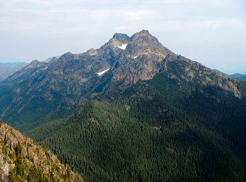
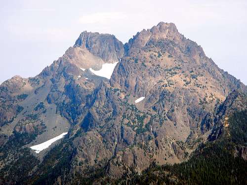 Upper Southwest Face
The Brothers was named after Arthur and Edward Fauntleroy in 1856 by a Captain of the United States Coast Survey, George Davidson. Better "The Brothers" than "The Fauntleroy's" I suppose. George Davidson also named nearby Mount Ellinor and Mount Constance after Ellinor and Constance Fauntleroy whom were sisters of the Fauntleroy brothers. Davidson was engaged to Constance and thus the affection for the Fauntleroy family.
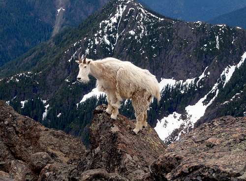 Goats Frequent The Summit
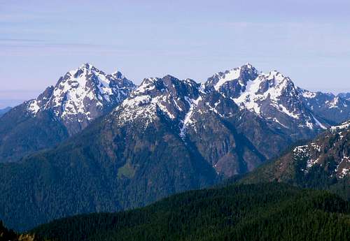
There are two summits which are separated by a saddle, one third of a mile as the bird flies. The south peak (Edward) is 192 feet higher. Although the north peak (Arthur) is lower, it was ascended first in 1908 by C. Hill and W. Hill. Success on the south peak came four years later in 1912 by I. Collier, O. Corkenill, W. Dehn, W. Fish, E. Goldsmith, and H. Trumbull.
Standard Route
Starting Elevation: 800 feet
Summit Elevation: 6842 feet
Total Gain: 6042 feet
Round Trip Distance: 16 miles
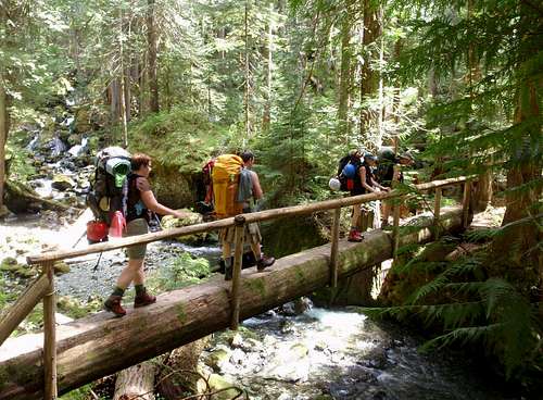
Begin at 800 feet in Lena Creek campground area. Follow the trail as it gradually rises for 3 miles to the north end of Lena Lake. During the weekend you can expect to see many campers gathered here. At the first major fork, turn right and cross Lena Creek on a log bridge. The left side of the fork would lead to upper Lena Lake.
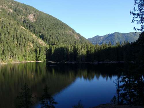 Lena Lake
Having crossed the main creek that feeds Lena Lake the trail enters the serene Valley of Silent Men. Some mountaineers I know claim that this is the most lovely valley in the Olympics. It is narrow at the base and has steep rising sides. It is filled with old-growth trees which are covered in mosses and at it's base flows the East Fork of Lena Creek. It is easy to imagine the extreme dampness that this valley must harbor for the majority of the year because even the ground and rocks are covered in rich green moss and lichen.
 The Valley Of Silent Men
There is a section of the valley where the East Fork Lena Creek seems to disappear as it flows down into the rocks underground. In this place, the valley is truly silent. From the north end of Lena Lake to the climbers camp is another 3 miles.
 The Brothers, Southwest Face
The climbers camp at 3000 feet is a conglomeration of odd shaped ground which is the result of many generations of fallen giant trees in different states of decay. The creek is near to many of the flat suitable tent spots, so filtering water is convenient to say the least. Not much sun reaches the ground under the thick forest.
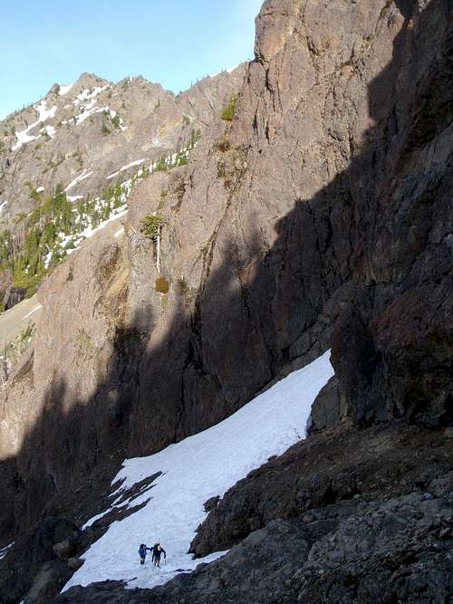 Two Climbers At 4000 Feet
Beyond the climbers camp there is only a scant boot-path. It can be easy to lose your way so pay attention and if you end up in the bushes, backtrack and look for the correct way. In the upper basin below the south face, you will encounter some burned trees, many of which have blown down by now. There was a fire in 1999 and another in 2003.
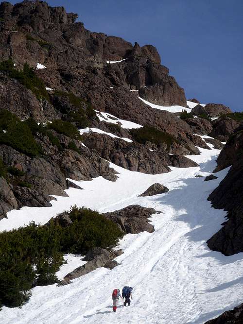 Entering The Gully
At about 4000 feet you will begin to leave the trees behind. For the most part, beyond it will be rocks and snow. Watch for goats for they are commonly seen here. Looking at the map you will see a couple of shallow gully's leading up out of the basin in a northwesterly direction. Also notice the minor ridge that comes down the center of the southern face in a north-south direction. Follow the northwesterly gully that leads to the western side of the small ridge. Follow this gully north to 5300 feet where you will cross rocks or snow (depending on the time of the year) east onto the top of the ridge.
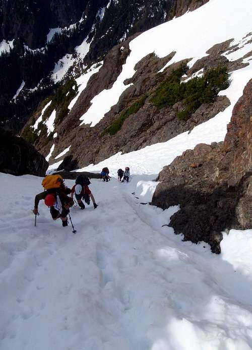 The Hourglass
Climb up on the top of the ridge for another 500 vertical feet at which point you will enter the gully again north by northwest. Stay in the gully and pass through the narrow section known as The Hourglass. At 6300 feet the route curves to the east avoiding the west ridge. Here the terrain is steepest reaching a maximum of 60 degrees. Depending on the time of year, it may be a total snow climb all the way from the climbers camp or there might be some scrambling mixed in as well. The majority of the route as it follows gully's and chutes does not exceed 45 degrees. When we were there, it seemed like if in doubt, go to the right. Be sure to check this GPS record of the route by Gabriel Deal.
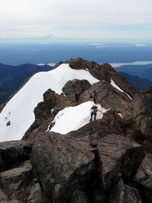 Near The Summit, May 2009
From the summit 360 degree views encompass many peaks in the heart of the Olympics and across the Puget Sound, the three large volcanoes Baker, Glacier, and Rainier. On a clear day, it's hard to find a more scenic summit in the Olympics.
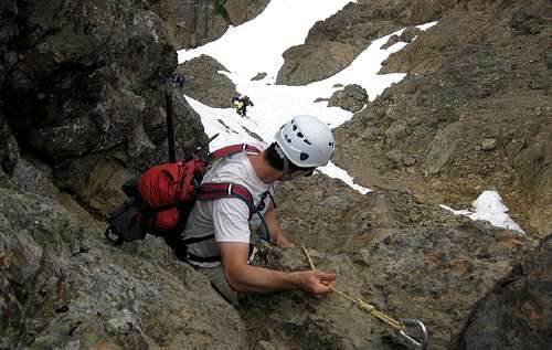 Downclimbing The Crux
Getting There
From the South:
From Olympia, WA take Highway 101 north 37 miles north to Hoodsport. 13.5 miles further north turn left onto Hamma Hamma River Rd. Go west 9.5 miles to the Lena Lake Trailhead at 685 feet.
From the North:
Make sure the Hood Canal Bridge is open. Take the Edmonds ferry to Kingston. From Kingston follow Highway 104 through Port Gamble for a total of 46 miles until your reach Highway 101. Follow 101 south 37 to Hamma Hamma River Rd. Go west 9.5 miles to the Lena Lake Trailhead at 685 feet.
Red Tape
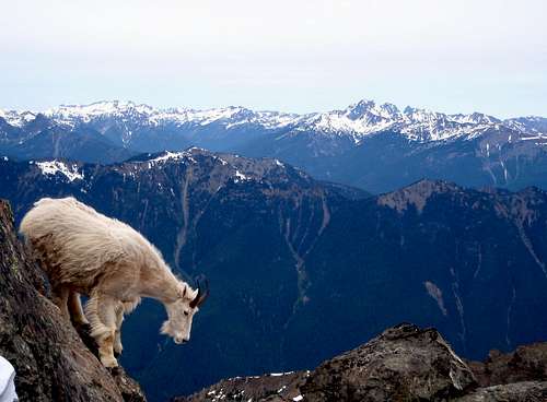 Goat Action
A Northwest Forest Pass is required at the trail head. Daily passes can be purchased with cash at the trail head for $5 a day.
If camping inside the Olympic National Forrest, back country permits are required. Depending on the time of the year, a camping reservation might also be necessary. The permits cost $5 + $2 per person per night. You can purchase them from the Wilderness Information Center in Port Angeles 360-565-3100
Camping
Lena Lake is a very popular place to camp in the spring and summer. There are many suitable spots to choose from all along the north shore. There are even a few outhouses near camp sites on the lake. There is also smaller climbers camp at 3000 feet in the upper Valley of Silent Men. Follow the main trail to where it peters out next to the east fork of Lena Creek. Please don't leave your garbage in the woods. Pack it in and pack it out.
External Links
 Mount Washington And Mount Pershing Seen From The Summit
- A 14 year old climbs The Brothers
- Route 1 Variation Trip Report
- Our Trip on the mountain. A report by SP user Magellan
- A Trip Report on the standard route
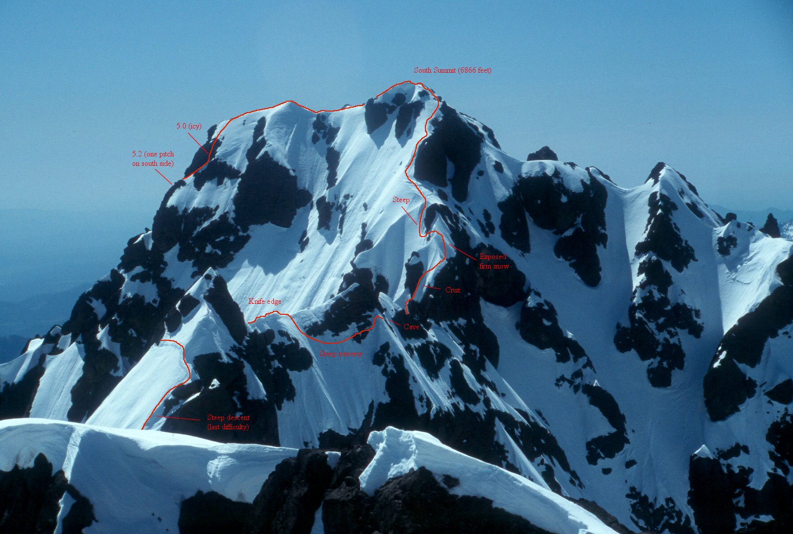
North Summit to South Summit Traverse
Here is a good route photograph that shows some details about the traverse. More information coming soon.
mandrake - Aug 2, 2010 5:42 pm - Hasn't voted
South Couloir approachAs of late July 2010, the trail was pretty obvious heading upwards along the west fork of the creek from the usual basecamp. What wasn't obvious was the junction about 0.6mi in where one should bear right. The trail then climbs up through an avalanche meadow, then enters a large burned out area. Continue following north and west until it enters a gully w/ stream which leads up to the south col. The route likely changes here frequently depending on snow conditions and how much water is coming down. The route crisscrossed the creek several times before emerging from the trees at the base of the southern couloir. Sustained 30-degree snow slopes above The Hourglass. Helmet, crampons and ice axe all essential. Bringing a rope and pickets may be a good idea if you have some less experienced folks on the team.
olywolf - Jun 17, 2015 4:01 pm - Hasn't voted
red tape required permitthe Brothers Wilderness is US Forest Service Land, not national park...no back country permit is required from the NPS Wilderness Information Center, only a Forest Service recreation pass here: http://www.fs.usda.gov/main/r6/passes-permits The Hood Canal Ranger District can be contacted for info about requirements: Hood Canal Ranger District – Quilcene Office 295142 Highway 101 South P.O. Box 280 Quilcene, WA 98376 (360) 765-2200