
-
 10699 Hits
-
 81.18% Score
-
 13 Votes
|
|
Mountain/Rock |
|---|---|
|
|
47.44568°N / 11.42110°E |
|
|
Hiking |
|
|
Spring, Summer, Fall |
|
|
8323 ft / 2537 m |
|
|
Overview
 Östliche Karwendelspitze (right) and Vogelkarspitze
If you are looking to the Karwendel ranges from northern or western directions you can see an eye-catching summit with a perpendicular northern rockwall: Östliche Karwendelspitze. This impressive looking summit stands in the northernmost range of Karwendel mountains, the so called "Nördliche Karwendelkette" between Grabenkarspitze in the east and the peculiar Vogelkarspitze with its flat top in the west in the easternmost part of this range. It is the highest point of this range.
The summit has two faces: the impressive rockwall in the north, falling down perpendicular over about 650 m of altitude difference and a meadow overgrown, partly rocky south slope, dropping steeply down into Karwendeltal, the huge, west - east running valley between Scharnitz and Karwendelhaus. The south slope is flanked and limited by two deep rock cirques: Grabenkar in the east and Vogelkar in the west.
In the north there are two valleys starting at or near the northern foot of the rockface: Rohntal and Tortal, side valleys of the Risstal / Eng.
The summit of Östliche Karwendelspitze is built of an arete which marks the German - Austrian border. The main summit is the corner where the borderline turns from an east-western in a northern direction. A secondary summit in the southern parts of the summit arete is bearing now a new summit cross which can be seen from the Karwendeltal and the Karwendelhütte but is not the highest point of the mountain.
Östliche Karwendelspitze was summited first by the famous mountain pioneer Hermann von Barth, on 04, july 1870.
The mountain is easiest accessible from the south through Grabenkar or via south slope. It is the most popular summit of the northern Karwendel range but this means not, that it is very crowded up there. Only on sunny summer and autumn weekends you will meet some other mountaineers on the routes of this interesting mountain.
  |
Getting There
 Ascent through Karwendeltal (may 2009)
The trailhead for the two normal routes to Östliche Karwendelspitze is Karwendelhaus, a huge mountain hut within the Karwendel mountains.
You reach Karwendelhaus from / by:
Scharnitz
This is the western ascent route to Karwendelhaus. Scharnitz can be reached from the direction of Munich by using highway A 95 and road B 2 to Garmisch-Partenkirchen, Mittenwald and the German - Austrian border at Scharnitz.
From the direction of Innsbruck use road number 177 via Seefeld to Scharnitz.
At Scharnitz church there is a signpost to “Karwendeltäler”. Follow this road to a huge parking area left of the road. If you go on the road there is another little parking area at the end of the village where the public road ends and the forest roads start. Both parking areas require fees !
At the second parking area there are many signposts. Use the road which branches off to the left, follow this road up into Karwendeltal to Larchetalm, Angeralm and then to Karwendelhaus. This is a very long hike, normally this ascent is done by bike, even in spring for a ski tour to Östliche Karwendelspitze. You will normally meet many mountain bikers because Karwendeltal is part of the Karwendel MB loop. In late spring there are several parts of the valley still filled up with avalanche snow so the road can be interrupted and you have to carry your bike across those avalanche masses.
Eng valley
This is the eastern ascent route to Karwendelhaus. From Munich use highway A 8 to the exit Holzkirchen. At Holzkirchen village follow road number B 13 to Bad Tölz, Lenggries and Sylvensteinspeicher, then B 307 to Vorderriss. At Vorderriss follow the road into Eng valley to Hinterriss and to the toll station. Park your car at the inn near the toll station or pay the road toll and go on for about 1 km to where the forest road to Johannistal branches off. There is a parking area, too.
For ascending to Karwendelhaus take the forest road into Johannistal which leads up to Kleiner Ahornboden where the famous mountain maples form an impressive grove. At Kleiner Ahornboden with the memorial of Hermann von Barth, the famous mountain pioneer in the 19th century, take trail number 201 to Hochalmsattel and to Karwendelhaus. This ascent can be done easily by foot or with bike (strenuous and steep).
 Ascent through Karwendeltal (may 2009)
Traverse from Falkenhütte
This is a wellknown hut to hut traverse. From Falkenhütte, another huge mountain club hut, take trail number 201 down to Kleiner Ahornboden and then the same trail up to Hochalmsattel and Karwendelhaus.
Mittenwald
Mittenwald is located in Germany north of Scharnitz. To get to Mittenwald, see the Scharnitz description.
North of Mittenwald are two barracks of the German army. Use road number St 2042 between Mittenwald and the northern Mittenwald exit from road number B 2. 500 m north of Mittenwald city limits an access road for the barracks branches off to the right and continues to the east between the two barracks. Just go straight on to the road passage underneath road number B 2. After the passage there is a parking area on the right.
Take the forest road left of the passage which leads up to Fereinalm. Alternatively leave the road at Aschauer Alm and take a trail called "Jägersteig", which leads to Fereinalm, too.
At Fereinalm (or Vereinsalm) take trail called "Gjaidsteig" to Bäralpl. From Bäralpl the Gjaidsteig runs high above Karwendeltal until it reaches Hochalmsattel and Karwendelhaus (the last part is called Maximiliansweg). The normal routes to Östliche Karwendelspitze are branching off this trail about 10 minutes before you reach Hochalmsattel (see the “Routes & Trails” section).
Normal Routes & Trails
 Östliche Karwendelspitze and Grabenkar (may 2009)
There are two normal routes to the summit of Östliche Karwendelspitze, both using the south side of this mountain:
Grabenkar route
This is an interesting mountaineering route and the spring ski route.
From Karwendelhaus follow the supply road to Hochalmsattel an take the Maximiliansweg in the direction of Bäralpl and Fereinalm. This trail traverses nearly level the southwest slopes of Grabenkarspitze and enters the lower end of Grabenkar. After traversing Grabenkar creek take the first trail which branches off to the right and ascends the south slope, following closely the Grabenkar creek.
Attention: There is another trail ascending the south slopes nearby. This one uses a scree chute between the dense dwarf pines to gain the south slope route of Östliche Karwendelspitze (see below).
Follow the first trail into the lower parts of Grabenkar; it leads up over stony steep meadows to the right hand scree fields of the impressive cirque and traverses on the scree fields the west slopes of Grabenkarspitze under the impressive rock faces of this mountain.
The trail goes steadily in northern and - higher up in the Grabenkar - in northwestern directions and follows then the broad, west - east running scree chute, the upper limitation of the Grabenkar. At the end of this chute there is some rock scramble involved, UIAA grade I and easier. In spring this part is normally still snow covered but very steep and can be a little challenge.
 Grabenkar ascent (may 2009)
The chute leads up to the summit cirque and the summit arete. At the western end of the summit arete, visible from Karwendelhaus, there is a newly erected summit cross. The main summit of Östliche Karwendelspitze is at the eastern end of the summit arete. Follow the easy arete from the new summit cross to the east. The summit block is separated from the arete by a notch, which has to be traversed to gain the summit. Leave the arete before you reach the notch and descent some 10 meters down the left, northwestern side of the arete; this is UIAA grade I. Traverse the notch and climb over some rocks - again UIAA grade I - to the summit with its tiny old summit cross and the marvellous views.
South slope route
With the Grabenkar route as an interesting ascent route you can make a nice and satisfying round trip by using the south slope route as your descent route.
As the south slope route is steep and on the south and hot side of the mountain, I recommend to descend via this route rather than ascend on it.
Follow the red marks near the summit cross of the secondary summit (!) first entering the wetsren side of the summit slopes. This is a steep rock and scree part of the descent. The narrow and steep trail returns to the south slope and zigzags steeply down. Follow closely the markings because there are several rockfaces on that south slope which can be a severe obstacle.
At the lower end of the south slope the trail turns in eastern direction to the lower east corner of the south slope. Don´t iss that part: the south slope ends high above Karwendeltal with a difficult rockwall.
At the eastern lower end of the south slope the trail gains the above described scree chute quite easily with some rock scramble. At the end of the scree chute the trail joins the Gjaidsteig / Maximiliansweg which leads quickly back to Karwendelhaus.
 Grabenkar and Grabenkarspitze (may 2009) Grabenkar and Grabenkarspitze (may 2009) |  Grabenkar (may 2009) Grabenkar (may 2009) |  Upper Grabenkar (may 2009) Upper Grabenkar (may 2009) |
Red Tape & Mountain Conditions
 Final ascent to the summit (may 2009)
Mountain Conditions
Östliche Karwendelspitze is mainly a summer and autumn hike.
For summer / autumn you need full hiking gear and good shoes as parts of the journey are on very narrow trails. Ropes and additional climbing gear is not required.
The ski ascent via Grabenkar should only be done in mid to late spring, when all the avalanches did went out of the steep rock faces and the situation is absolutely secure. In my opinion Östliche Karwendelspitze is not a winter or early spring ski hike.
You need full ski hike gear and optional avalanche gear. Crampons and ice axe is normally not required.
Check the Tirol avalanche bulletin here
Check the Tirol weather conditions here
Red Tape
Östliche Karwendelspitze is part of a national park, the “Alpenpark Karwendel”.
There is no entrance fee for the park or any permit required. Nevertheless there are some reglementations:
Fires, Camping, noise and litter are prohibited within the park boundaries.
Do not pick up plants or parts of them.
Do not remove or disturb animals. Dogs must be leashed within the park.
Mountain biking is only possible on signposted routes, normally the forest roads.
Marked trails should not be left (at least you should stay on the routes described in the Karwendel mountain guides).
Accomodations
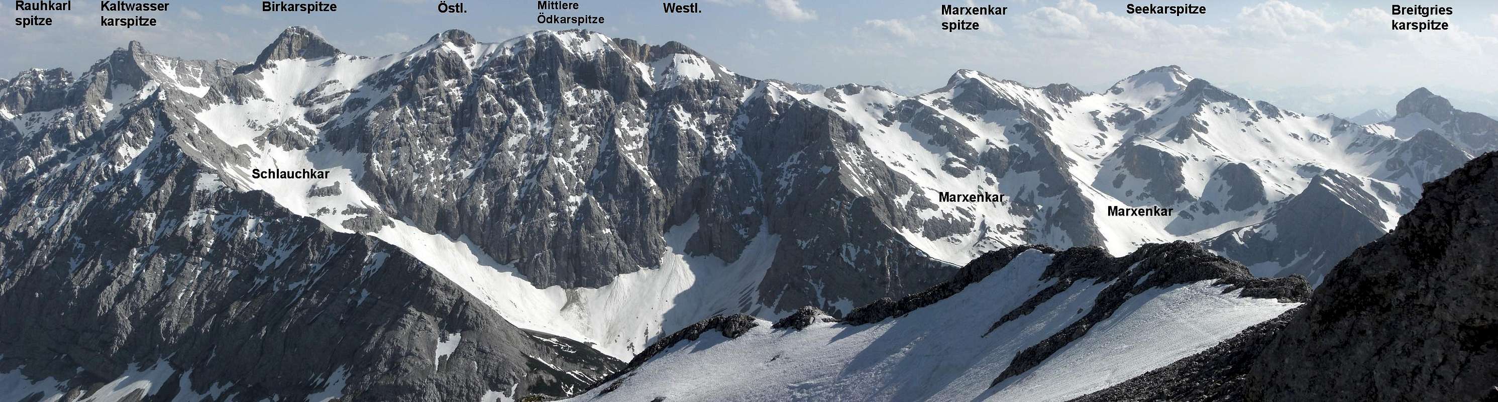
 Summit cirque with view to Birkarspitze (may 2009)
You find all kinds of accomodations in the nearby villages:
Vorderriß
Hinterriß
Scharnitz
Seefeld
Mittenwald
These guarded mountain (club) huts are near Östliche Karwendelspitze and offer beds for an overnight stay:
Karwendelhaus
Falkenhütte
Unfortunately former Larchetalm is now closed down and demolished!
Maps & Guide Books
 Grabenkar ski ascent (may 2009)
Maps
Alpenvereinskarte 1 : 25.000
Blatt Nr. 5/2, Mittleres Blatt
Online Shop Deutscher Alpenverein
For the Karwendelhaus ascents you need:
Alpenvereinskarte 1 : 25.000
Blatt Nr. 5/1, Westliches Blatt
Online Shop Deutscher Alpenverein
Bayerische Topographische Karte 1 : 50.000
Karwendel, UK 50/51
Landessamt für Vermessung und Geoinformation, München
Guide Books
Walter Klier
Alpenvereinsführer Karwendel alpin
Bergverlag Rother, München
for rock climbing:
Walter Klier
Alpenvereinsführer extrem
Bergverlag Rother, München
(out of stock)
Available only in German