
|
|
Mountain/Rock |
|---|---|
|
|
40.97660°N / 114.3094°W |
|
|
Elko |
|
|
Hiking |
|
|
Spring, Summer, Fall, Winter |
|
|
8037 ft / 2450 m |
|
|
Toano Highpoint
Overview
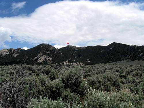
This peak is one of those that is pretty close to an interstate, I-80, just west of Wendover Nevada. Not a difficult mountain to scale, it can be ascended in about an hour or so and is mainly of interest to those who are interested in prominence. Toano comes in at #147 on the Nevada prominence list with prominence of 2127'. This is the highpoint of the Toano mountain range and has no trail but yet it is an easy cross country effort if you have the summit area waypointed on a GPS.The highest point is visible from the interstate but if you were to try and guess which peak is the highest, you most likely would guess wrong.
Wikipedia link for map that indicates the overall Toano range
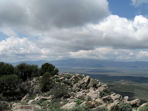
View from summit area - south
Getting There
From Wendover, go west about 20 miles to the I-80 exit 387. Just beyond the exit there is a dirt road on the north side, take this and follow it as it ambles northward a good three to four miles (didn't get exact mileage) to a "T" junction. The road is fairly rough but most cars could probably get to the "T" junction with careful driving. This junction is at 40.9797 -114.3300 at 6700' of elevation. For anyone with less than high clearance, this would be a good place to park and begin your hike. From here it is 1.2 miles to the summit (GPS) and you'd have an elevation gain of over 1300' Just head straight across the scrub brush to the west slope of the mountain.For those with higher clearance, take the left and proceed 0.2 miles to a "Y" and take the right fork. In about a half mile, watch for a faint track that goes off to the right and turn onto it. (GPS nad 27 40.9836 -114.3224) Follow this faint track for about a half mile as it goes towards the southeast but taking you closer to the base of mountain. Park where you are comfortable and I parked at 40.9781 -114.3189 (7020') This left us about 0.6 mile (GPS) and a thousand feet of elevation gain to deal with.
Note: In 2012, Dennis Poulin added his refinements and I have borrowed this from his trip report at peakbagger.com:
I used Dean's report from Summit Post, but I got confused on the driving part. Here is how I got to the trailhead. From Exit 387, I went to the north side of I-80 and turned east. I went 0.2 mile and turned north on a good dirt road. 2.2 miles from I-80 I went straight (the road to the right may go to the trailhead, but I didn't check it out). At 3.2 miles I took the right fork and at 3.6 miles I turned right on a lesser road. On this lesser road I didn't go far. In .2 mile I turned right, at .3 mile go right, at .4 mile I parked at about 7,000 ft on the west side of Toano. Steep hike up the west side through the trees..

My trailhead
Red Tape
As far as I know, there isn't any red tape and no signs indicating private property.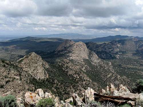
Summit view - north
Camping
Since the hike is an easy one, there shouldn't be a need for camping unless arriving late in the day. You could bush camp using the leave no trace ethicsif necessary or stay in Wendover, which has many motels at fairly reasonable rates.


Weather (Wendover)
 Wendover linksHistory
Campgrounds
Motels & accomodations
Wikipedia
Route information
From the west side, it is all cross country with less than a mile of effort involved and about a thousand feet of elevation to be gained. Near the top, you encounter talus and rather than scramble up the south ridge, there is a nice way to the summit area on the east side, accessed by skirting the rocky south ridgeline and finding a plateau area on the east. Walk north till you see an easy way up to the high point. A register was found in a small rock cairn on the summit area (which is fairly flat).When Dennis Poulin visited the mountain, he kept a GPS track of his roundtrip climb and it was just a bit north of the route that Ken Jones and I used. See his route HERE.
James Barlow used a route that brought him in from the north and he posted his route information and a GPS track HERE.
Lane Johnson describes his route HERE and Sam Grant posted a GPS track of his west side route.
So, as you can see, you can use several ways to get up to the top of this one, just go for it.
Be aware that this is rattlesnake country and so being alert and watching the ground in front and to the side of you is very important.

Summit register
A small register with very few entries was found. Below are the two pages we found. I knew who most of those that signed the register were. Seven people in about ten years indicates that this peak receives very few visitors.
Register
After Ken and I visited in 2009, three years went by before the next visitors.
2012 - Victor Zhou
2012 - Brett Hathaway
2012 - Dennis Poulin
2012 - Chris H
2014 - Kelly and Terry Lister
2015 - James Barlow
2015 - Lane Johnson
2015 - Sam Grant

Second page of register
From I-80 area
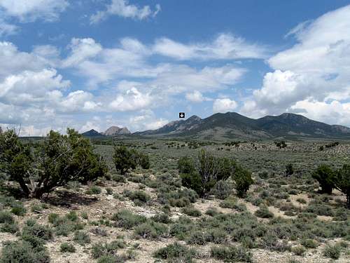
As seen from near I-80