
|
|
Mountain/Rock |
|---|---|
|
|
56.63782°N / 5.01028°W |
|
|
Hiking, Mountaineering, Scrambling, Skiing |
|
|
Spring, Summer, Fall, Winter |
|
|
3517 ft / 1072 m |
|
|
Overview
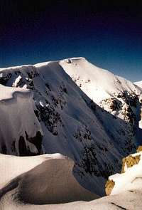
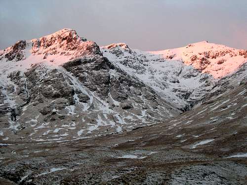
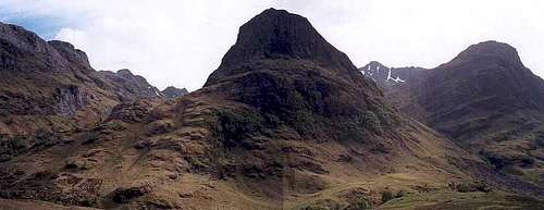
Stob Coire Sgreamhach (Translation; Peak of the Fearful Corrie) is located in Glencoe, just to the east of the areas largest peak Bidean nam Bian. Stob Coire Sgreamhach (Pronounced; Stop korra skree-yach) stands at a height of 1072m/3517ft and is listed as No.65 in the Scottish Munro's list.
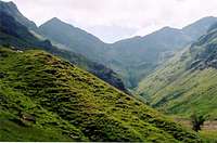
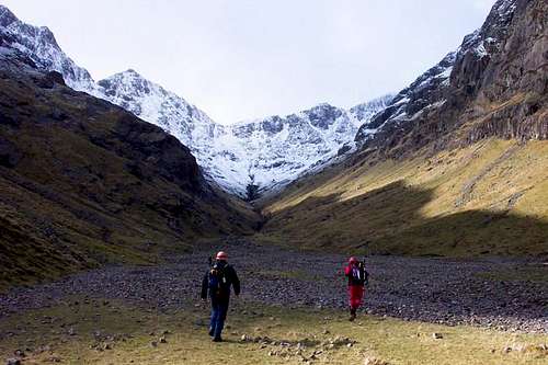
Sgreamhach and the subsidary long ridge of Beinn Fhada that stretches out towards Glencoe, form the jagged outline at the head of Coire Gabhail (The Lost Valley), and it is from this corrie that the peak is most commonly ascended. The hike up and into Coire Gabhail requires a steep climb up next to the Allt Coire Gabhail before the terrain eventually levels and you find yourself in amongst the corries surprisingly flat and lush lower reaches. The route along the long lengths of Coire Gabhail eventually leads to the bealach between Sgreamhach and Bidean. The final stages to the bealach are covered in scree and the many feet trampling up and down over the years have caused serious erosion, making the going underfoot quite difficult. From the bealach, a gentle climb east south east will lead to the summit cairn.
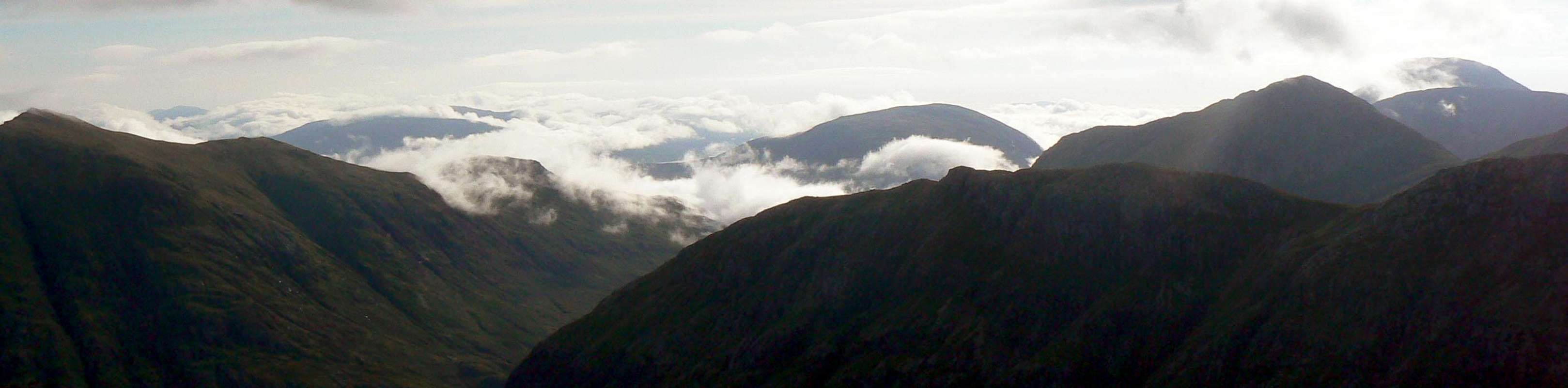
There are splendid views to be had once on the summit, with all of the Glencoe peaks in the east, north and west visible on a clear day. To the south, the views into Glen Etive and all the way down to Loch Etive are truly marvellous.
Glencoe Vista
Getting There
Airports
For arriving in Scotland and making your way to Glencoe, the best airports to arrive in are;
Car
From Glasgow take the A82 road via Loch Lomond northbound direct to Glencoe.
From Inverness take the A82 southbound via Fort William direct to Glencoe.
From Edinburgh take the M9 to Stirling, then take the A84 Callander road, becoming the A85 until merging with the A82 northbound road at Crianlarich then on to Glencoe.
Rail, Bus or Ferry
Traveline Scotland - A one stop shop for all of the above
 |
 |
 |
Red Tape
There is no red tape in Scotland due to the Land Reform (Scotland) Act 2003 which incorporated the Scottish Outdoor Access Code. This code, which commenced on the 9th of February 2005, has established statutory rights of access to land and inland water for outdoor recreation.
The Land Reform(Scotland) Act 2003
The following aspects should be taken into consideration when you are in the Scottish countryside;
- Seek local advice in regard to deer stalking or grouse shooting activities
- Ensure that all gates are closed behind you
- During the lambing season (March to May) ensure that all dogs are kept on a lead
- Please refrain from feeding or annoying any animals
- Limited parking space is available at the start of many routes, please ensure that you are not blocking a road and/or entrance
- Parking is provided at the start of some routes by the local farmers, it is polite to ask if you can use this facility
- Try to refrain from crossing fields with animals and/or crops if an alternative route is available
- Ensure that you treat the local environment with care by leaving it as you found it and by taking any litter home with you
- Any camp fires should be carefully watched and only used away from dense forest areas
Local Accommodation
 |
 |
 |
The best place to base yourself for climbing Bidean nam Bian is in or around the Glencoe area. Below is a selection of available accommodation;
Hotels
Lodges & B&B's
Hostels & Campsites
Caolasnacon Caravan & Camping Park
Wild Camping
Wild camping is totally legal in Scotland and can be done in various locations in Glencoe. This is due to the Land Reform (Scotland) Act 2003 that was mentioned earlier. Here are some of the basic rules that should be adopted when wild camping;
- The larger the group, the harder it is to keep impacts to a minimum. Keep groups small.
- Camp as unobtrusively as possible.
- Remember that noise travels from tents disturbing wildlife as well as humans.
- Enjoy the freedom of wild camping without leaving a trace of your passage. Protect our country's outstanding scenery and wildlife as well as the wilderness experience.
- Camping on the same spot harms vegetation. Aim to move frequently and do not stay for any longer than 3 nights in the same place.
- Lighting fires poses a high fire risk on peaty soils and close to tinder dry grass. A high risk of fire can exist at any time of year, and not just in times of drought.
- Watercourses and loch sides are important sites for birds and animals. Take extra care when camping near burns and lochs, and try to avoid camping immediately beside them.
- Always find a spot at least 30 metres from fresh/running water when going to the toilet.
- Bury excrement in a small hole (not under boulders). A trowel or ice axe can be used to lift a flap of turf.
- Remove all litter (even other peoples!) Think ahead and only carry in what you are prepared to carry out.
Mountain/Weather Conditions
The weather conditions in Glencoe can alter rapidly and you should ensure you are fully prepared for all weather eventualities. The following websites will provide invaluable information on the expected conditions for your planned trip;
Mountain Weather Information Service - West Highlands
Mountain Forecast - Pap of Glencoe
Met Office Mountain Forecast - Southwest Highlands
Scottish Avalanche Information Service - Glencoe
As stated, the peaks in the Glencoe region sit close to the west coast of Scotland. This can have a strong affect on the conditions on the mountains and it is a regular occurrence for Glencoe to experience its very own weather system and for it to totally differ to the weather in the nearby towns and villages. More detail can be found on the reasons for this occurrence on Proterra's article: Mountain meteorology of Scotland.
Books & Maps
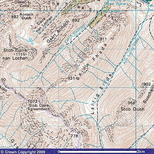
Image reproduced with permission of Ordnance Survey and Ordnance Survey of Northern Ireland.
Books
Central Highlands by Peter Hodgkiss
The Munros by Donald Bennet & Rab Anderson
Glencoe Climbers Guide by Rab Anderson, Ken Crocket & David Cuthbertson
Highland Scrambles South by Iain Thow
Ski Mountaineering in Scotland by Donald Bennet & Bill Wallace
Hostile Habitats by Mark Wrightham & Nick Kempe
Scottish Hill Names by Peter Drummond
Ben Nevis & Glencoe by Ronald Turnbull
Maps
OS Explorer 384 - Glencoe and Glen Etive
OS Landranger 41 - Ben Nevis: Fort William & Glencoe
Harvey Superwalker Map - Glencoe
External Links
Walking through the lost valley.
Mountain Rescue Committee of Scotland
Heading For The Scottish Hills
The Scottish Mountaineering Club