
-
 11165 Hits
-
 83.1% Score
-
 16 Votes
|
|
Mountain/Rock |
|---|---|
|
|
46.18256°N / 16.12621°E |
|
|
Hiking |
|
|
Spring, Summer, Fall, Winter |
|
|
3478 ft / 1060 m |
|
|
Topographic isolation: 57 km
Nearest higher peak: Ledinekov Kogl (1182 m)
Prominence: 810 m![Ivanaica vintage shot]()
Vintage photo about Ivanscica from the 1930'sIvanščica (also called Ivančica, and Ivaneci-hegység in Hungarian) is the highest mountain of Hrvatsko Zagorje region. North slope of the mountain that descends into the valley of river Bednja has a very nice mountain terrain. It is very steep and has its special vegetation. Ivanščica is about 30 km long and 9 Km wide. Its spreading from east to west and its a very nice example of chain type of mountains with its highest peak of 1060 meters. It can be considered as the farthest southeast end of the Alps. The mountain has a smaller western mass north to Krapina, with its highest elevation of 846 m. The west-east ridge of the mountain is the watershed between the valley of Drava in north and the valley of Sava in south.
Mountain belt above 300 meters is mainly covered by beech tree forests. In lower parts forests consist mainly of oak trees. For the first look this mountain looks pretty tame but its steep slopes and bare rocks tell a different story. Some parts of the mountain like stone reef of Legisičine, rocks under Belige and the steep slope near Belecgrad ancient ruins have climate that is pretty much like in the Alps.
With rich views, shade of dense forests, and the highest peak of northern Croatia Ivanščica is mountain climbers’ paradaise. For a considerable part of Hungary this mountain is the nearest mountain with a peak over 1000 m, and it makes this mountain popular also for Hungarian hikers.
For the map of the mountain click here
In distant geological past tectonic movements were very strong and intense in this region. Ivanšcica is intersected by big splits on northern and southern side, and many smaller splits are in its central part. Tectonic movements are often followed by volcanic actions, and as a consequence of this activity the mountain is very rich in minerals.
On the edges of the splits lava passed, volcanic eruptions occurred and with them thermal waters emerged in which there were many minerals and ores. These volcanic occurrences are responsible for creation of many layers of ore and minerals.
Extracted from the study "Mineral and rocks of Ivancica" of academic Mirko Melez: Our mountains 4/1952 num 7-8
Up to now about 60 types of minerals have been discovered. Mainly in rock form and far less in layer form. Identified minerals of Ivanšcica:
Achat, albitm, amfibol, andezit, anglezit, antigorit, apatit, augit, biotit, bitovnit, bornit, brukit, Ca – montmorilonit, cerusit, cirkon, delesit, dichardit, diopsid augit, dolomit, epidot, galenit, getit, granat, halkopirit, halkozin, hausmanit, hematit, hemimorfit, heulandit, hidrobiotit, hidrocinkit, hipersten, idingsit, ilit, ilmenit, jaspis, kalcedon, kalcit, kaolin, clorit, kovelin, quarz, labrador, leukoxen, limonit, magnetit, martit, minerali glina, montmorilonit, mordenit, oligoclas, onix, opal, penin, pirit, piroxen, piroluzit, prehnit, pumpeliit, ransieit, rodohrozit, rutil, sanidin, seladonit, sericit, serpentin, sfelerit, siderit, skapolit, smithsonit, specularit, spinel, talk, titan-ferrum augit, todorokit, turmalin, uralit, vermikulit.![Belecgrad - ruins]()
Belecgrad ruins![The peak of Ivanšcica as seen from the hillside of Konj]()
The summitThe peak of Ivanščica is located 1060 meters above the sea level. It’s called Ivanščica, too. It is the main destination of most hikers who come to visit Ivanšcica. Nearby the mountain hut "Pasarićeva kuća" there are two lookout points. From the smaller one "Stricevo" you can see big area towards north, seeing Ivanec, Varaždin and the Međiumurje region.
On the highest spot on the mountain a lookout tower shaping an iron "Pyramid" is built. It is 10 meter high. On the same spot in 1893 mountaineers from Ivanec built a small wooden pyramid and next to it a small shelter, that was predecessor of today’s modern tower and huts.
Around the hut and the tower there are several wooden benches and tables for hundreds of mountaineers.
Important events at Ivanšcica
1st of May picnic
1st of May picnic is gathering of mountaineers and visitors with more than 1000 participants. It lasts for 2 or 3 days.
Walking-Health
Manifestation „Walking-health“ is held during the last week of July. Participants walk from the center of Ivanec across Mrzljak towards the top of the peak Ivanščica where sport competitions are held at the playground near the mountain climbers’ hut. After the intense competitions a nice party is held
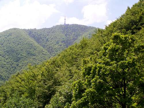
Ivanščica is very popular amongst paragliders who have their starting ground on the peak. Starting ground is located at the top of the skiing path, near the TV transmitter station.
One the northern slopes of Ivanščica, on a steep slope called Jarki, there is a skiing path whith slope of 22–30%. Its length is about 500 meters.![The Chapel Sv. Duh at Prigorec]()
PrigorecThe natural tourist centre of the mountain Ivanšcica is the city of Ivanec. Also the most appropriate routes to the peak start here. But there are other routes to the peak, too.
Routes from Ivanec
Ivanec – Prigorec – Konj – Pasarićeva hut (the peak)
Perhaps this is the best route up to the peak. We start from the main square of Ivanec towards Ivanšcica. After 3,5 km we arrive to Prigorec. This section can be done by car, too. At the end of the village where 2 paths split we go straight. On a steep path we climb to Mali Konj. Then we climb the near the reef to Veliki Konj (839 m). From there it’s about a 45 minutes of walking to the peak. The distance from Ivanec to the peak is 6.5 km. The whole climb takes about 2.5 hours if you don’t want to hit records. The starting point – the main square of Ivanec – is on elevation of 227 m. The peak is on 1060 m, so the elevation gain of the route is 833 meter.
Ivanec – Pilana – Mrzljak – Crne mlake – Pasarićeva hut
We start on the road from Ivanec towards Ivanščica. We follow the road, and after 2.5 km walk, at Pilana we get off the road and go right. While we climb the slope becomes steeper and steeper. After 30 minutes of walk we get to the field near the Zgano Vino spring. Then we go straight forward on a forest path and after 1 km on a small hill on the right is the resting area near Mrzljak spring. Then again we go right and with on a bigger slope we get to a small valley beneath Crne mlake. By path near Crne mlake we get to the 4 x 4 road leading to the summit. Continue walking on the road and in 30 minutes you can get to the top. The described route is approximately a 3 hour’s walk.
Ivanec – Prigorec – Prekrižje – Pasarićeva hut
From Ivanec we go to Prigorac. At the end of the village where mountain paths separate we turn left. Then we ascent on the 4 x 4 road to Prekrizje through the Javornjak forest. It takes 2 x 5.6 km. From Prekrizje to the summit there is about a 1 hour’s walk. The whole climb by this path lasts about 4 hours. This is the easiest path. In order to see the route on map, click here.
Ivanec – Prigorec – Pasarićeva hut (on road)
We go from Ivanec to Prigorac on the road. When entering the village we turn right near the chapel. We go past Zganon Vina and get to parking lot near “Pasarićeva hut”. The 4 x 4 road is in good condition and can be used by all types of vehicles, except during the winter and after heavy rains.
Lepoglava – Šumec – Košenicke livade – Pasarićeva hut
From Lepoglava we go towards Golubovac near Šumec. Near the statue of Virgin Mary we go left on a steady climb and we pass near “Brackove” cave to “Maks” spring and later near old Vudelje quarry. Above the quarry we turn left towards “Vilincu” cliff in order to enjoy the excellent view. From there the road leads towards Pregarske krci, on the left side there are two caves. Through beech forest we get to a crosspath where we go straight on to ”Malih Krca” where you get to the 4 x 4 road that comes from Ivanec. It’s a 1.5 hour’s walk to get to the Pasarićeva hut. The total length of this route is 15 km long and it’s pretty intense because of steep slopes.
Lepoglava - Pasarićeva hut – Ivanec
If you want to see a saved route of 21 km on Wikiloc, click here
Two routes from south, from the village Belec or from Gornja Selnica
Click >here for seeing the routes on map. On the opened page click on "Ivanscica/Karte"![If the hill is not enough high: look upwards the sky]()
Clean nature![Starting point of the route is here in Ivanec. And the peak is up there]()
View of the summit from Ivanec
Tourist hut – click here for the website in Croatian
Nearest higher peak: Ledinekov Kogl (1182 m)
Prominence: 810 m
Overview

Vintage photo about Ivanscica from the 1930's
Mountain belt above 300 meters is mainly covered by beech tree forests. In lower parts forests consist mainly of oak trees. For the first look this mountain looks pretty tame but its steep slopes and bare rocks tell a different story. Some parts of the mountain like stone reef of Legisičine, rocks under Belige and the steep slope near Belecgrad ancient ruins have climate that is pretty much like in the Alps.
With rich views, shade of dense forests, and the highest peak of northern Croatia Ivanščica is mountain climbers’ paradaise. For a considerable part of Hungary this mountain is the nearest mountain with a peak over 1000 m, and it makes this mountain popular also for Hungarian hikers.
For the map of the mountain click here
Geology and Minerals
Inner part of mountain chain is made from rocks Paleozolic and Mesozoic age, and edges are made from rocks of Cenozoic age. The oldest rocks that make inner part of the mountain are Paleozoic carbon rocks and clay rocks. On top of them there are Mesozoic trisikal rocks and dolomites which make the most of the whole mountain chain. Edges are made from Tercial age layers and from Oligocene rocks and sandstone. Sediments of the slopes are covered by Quarter age diluvia clay.In distant geological past tectonic movements were very strong and intense in this region. Ivanšcica is intersected by big splits on northern and southern side, and many smaller splits are in its central part. Tectonic movements are often followed by volcanic actions, and as a consequence of this activity the mountain is very rich in minerals.
On the edges of the splits lava passed, volcanic eruptions occurred and with them thermal waters emerged in which there were many minerals and ores. These volcanic occurrences are responsible for creation of many layers of ore and minerals.
Extracted from the study "Mineral and rocks of Ivancica" of academic Mirko Melez: Our mountains 4/1952 num 7-8
Up to now about 60 types of minerals have been discovered. Mainly in rock form and far less in layer form. Identified minerals of Ivanšcica:
Achat, albitm, amfibol, andezit, anglezit, antigorit, apatit, augit, biotit, bitovnit, bornit, brukit, Ca – montmorilonit, cerusit, cirkon, delesit, dichardit, diopsid augit, dolomit, epidot, galenit, getit, granat, halkopirit, halkozin, hausmanit, hematit, hemimorfit, heulandit, hidrobiotit, hidrocinkit, hipersten, idingsit, ilit, ilmenit, jaspis, kalcedon, kalcit, kaolin, clorit, kovelin, quarz, labrador, leukoxen, limonit, magnetit, martit, minerali glina, montmorilonit, mordenit, oligoclas, onix, opal, penin, pirit, piroxen, piroluzit, prehnit, pumpeliit, ransieit, rodohrozit, rutil, sanidin, seladonit, sericit, serpentin, sfelerit, siderit, skapolit, smithsonit, specularit, spinel, talk, titan-ferrum augit, todorokit, turmalin, uralit, vermikulit.
Castle Ruins in the Mountain
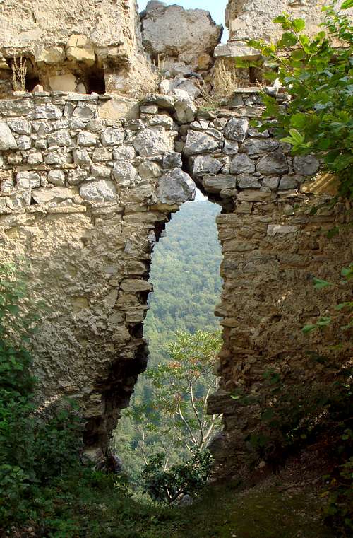
Belecgrad ruins
- Pusta Bela, 320 m
- Milengrad, 430 m
- Grebengrad, 502 m
- Pusti Lobor, 520 m
- Belecgrad, 539 m
- Židovina, 692 m
- Oštrcgrad, 746 m
The Peak
The summit
On the highest spot on the mountain a lookout tower shaping an iron "Pyramid" is built. It is 10 meter high. On the same spot in 1893 mountaineers from Ivanec built a small wooden pyramid and next to it a small shelter, that was predecessor of today’s modern tower and huts.
Around the hut and the tower there are several wooden benches and tables for hundreds of mountaineers.
Important events at Ivanšcica
1st of May picnic
1st of May picnic is gathering of mountaineers and visitors with more than 1000 participants. It lasts for 2 or 3 days.
Walking-Health
Manifestation „Walking-health“ is held during the last week of July. Participants walk from the center of Ivanec across Mrzljak towards the top of the peak Ivanščica where sport competitions are held at the playground near the mountain climbers’ hut. After the intense competitions a nice party is held
Ivanščica is very popular amongst paragliders who have their starting ground on the peak. Starting ground is located at the top of the skiing path, near the TV transmitter station.
One the northern slopes of Ivanščica, on a steep slope called Jarki, there is a skiing path whith slope of 22–30%. Its length is about 500 meters.
Routes
Prigorec
Routes from Ivanec
Ivanec – Prigorec – Konj – Pasarićeva hut (the peak)
Perhaps this is the best route up to the peak. We start from the main square of Ivanec towards Ivanšcica. After 3,5 km we arrive to Prigorec. This section can be done by car, too. At the end of the village where 2 paths split we go straight. On a steep path we climb to Mali Konj. Then we climb the near the reef to Veliki Konj (839 m). From there it’s about a 45 minutes of walking to the peak. The distance from Ivanec to the peak is 6.5 km. The whole climb takes about 2.5 hours if you don’t want to hit records. The starting point – the main square of Ivanec – is on elevation of 227 m. The peak is on 1060 m, so the elevation gain of the route is 833 meter.
Ivanec – Pilana – Mrzljak – Crne mlake – Pasarićeva hut
We start on the road from Ivanec towards Ivanščica. We follow the road, and after 2.5 km walk, at Pilana we get off the road and go right. While we climb the slope becomes steeper and steeper. After 30 minutes of walk we get to the field near the Zgano Vino spring. Then we go straight forward on a forest path and after 1 km on a small hill on the right is the resting area near Mrzljak spring. Then again we go right and with on a bigger slope we get to a small valley beneath Crne mlake. By path near Crne mlake we get to the 4 x 4 road leading to the summit. Continue walking on the road and in 30 minutes you can get to the top. The described route is approximately a 3 hour’s walk.
Ivanec – Prigorec – Prekrižje – Pasarićeva hut
From Ivanec we go to Prigorac. At the end of the village where mountain paths separate we turn left. Then we ascent on the 4 x 4 road to Prekrizje through the Javornjak forest. It takes 2 x 5.6 km. From Prekrizje to the summit there is about a 1 hour’s walk. The whole climb by this path lasts about 4 hours. This is the easiest path. In order to see the route on map, click here.
Ivanec – Prigorec – Pasarićeva hut (on road)
We go from Ivanec to Prigorac on the road. When entering the village we turn right near the chapel. We go past Zganon Vina and get to parking lot near “Pasarićeva hut”. The 4 x 4 road is in good condition and can be used by all types of vehicles, except during the winter and after heavy rains.
Lepoglava – Šumec – Košenicke livade – Pasarićeva hut
From Lepoglava we go towards Golubovac near Šumec. Near the statue of Virgin Mary we go left on a steady climb and we pass near “Brackove” cave to “Maks” spring and later near old Vudelje quarry. Above the quarry we turn left towards “Vilincu” cliff in order to enjoy the excellent view. From there the road leads towards Pregarske krci, on the left side there are two caves. Through beech forest we get to a crosspath where we go straight on to ”Malih Krca” where you get to the 4 x 4 road that comes from Ivanec. It’s a 1.5 hour’s walk to get to the Pasarićeva hut. The total length of this route is 15 km long and it’s pretty intense because of steep slopes.
Lepoglava - Pasarićeva hut – Ivanec
If you want to see a saved route of 21 km on Wikiloc, click here
Two routes from south, from the village Belec or from Gornja Selnica
Click >here for seeing the routes on map. On the opened page click on "Ivanscica/Karte"
Red Tape
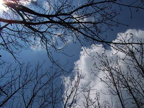
Clean nature
In Croatia, any form of camping in free areas outside registered camping sites, or parking areas for caravans and motorised campers, is forbidden and is punishable by law
Getting There
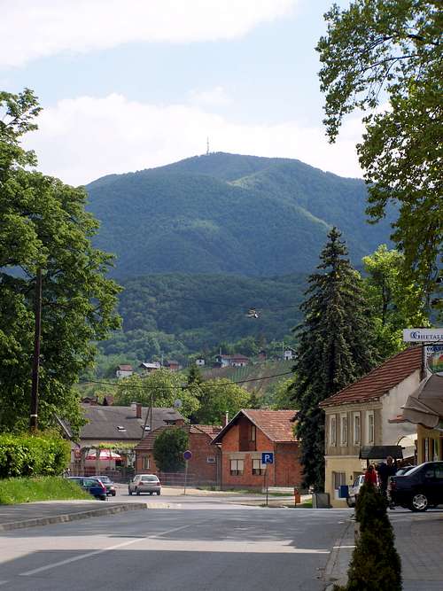
View of the summit from Ivanec
The natural tourist center of Ivanščica is the small city Ivanec (Hungarian: Ivánc). Major cities nearby: Varaždin (Hungarian: Varasd) in 22 km distance from Ivanec and Zagreb (Hungarian: Zágráb) in 62 km distance.
Approaching from Zagreb take the highway to north to the direction of Maribor. Get off the highway to east in the direction of Lepoglava. After a further 8 km you are in Ivanec.
If you come from Hungary, you can take the highway from Budapest to Varaždin. Ivanec is in a further 22 km from there.
It's more complicated to find the right direction from the souther part of the mountain – if you are not an expert, aim for Ivanec on the north.
Accomodation
No camping nearby the mountain Ivanščica.Tourist hut – click here for the website in Croatian