
-
 24662 Hits
-
 84.82% Score
-
 19 Votes
|
|
Mountain/Rock |
|---|---|
|
|
48.06880°N / 121.35403°W |
|
|
Snohomish |
|
|
Hiking, Mountaineering |
|
|
Spring, Summer, Fall, Winter |
|
|
6554 ft / 1998 m |
|
|
Overview
 Bedal Seen From Sloan Peak, October 2010
Named after James Bedal, an early pioneer of the late 1800's, Bedal Peak is roughly pyramid shaped with three main ridges and three sides. At the base of the north face runs the North Fork Sauk River. At the base of the west face runs Bedal Creek. At the base of the east face runs Cougar Creek and this divides Bedal Peak from neighboring Sloan Peak. It is likely that the first ascent was achieved in 1921 by James Bedal's son Harry who lived in a trappers cabin in the upper Bedal Creek Basin.
 Bedal North Face
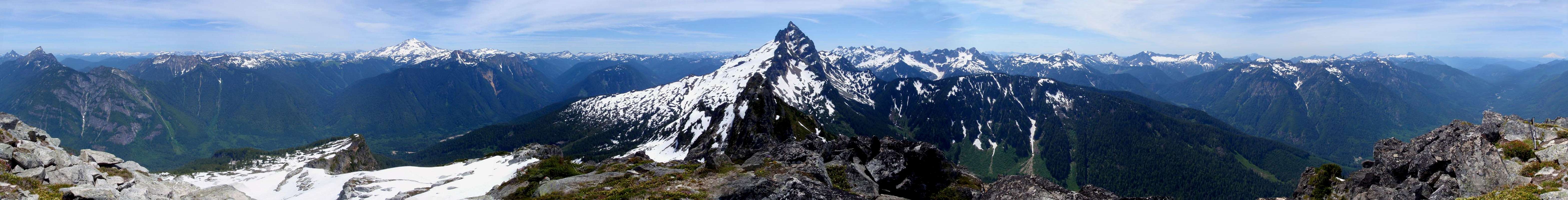
The summit is composed of orthogneiss and from there, one may behold some of the most dramatic views available on the Mountain Loop Highway. Peaks which are easy to identify from the summit on a clear day include: Baker, White Chuck, Pugh, Spring, Breccia, Zi iob, Bonanza, Glacier, Black, Painted, Kololo, White, Indian Head, Sloan, Kyes, Cadet, Columbia, Foggy, Rainier, Sheep, Del Campo, Lewis, Morning Star, Vega, Sperry, Vesper, Big Four, Hall, Pilchuck, Dickerman, Twin Peaks, Forgotten, Liberty, Big Bear, Three Fingers, Helena, Bullon, Jumbo, Whitehorse. Bedal is often overlooked because of it's proximity to the local prominent Sloan. If you are looking for a bit of a challenge, Bedal's summit is one of the more rewarding goals in the immediate area. The standard route gains 4500 feet in 4 miles.
The Summit
Getting There
From Darrington drive south on the mountain loop highway 17 miles to Bedal Campground. Just past the campground you will cross a bridge and then shortly on your left is forest road 4096. Turn left and proceed 1.3 miles tot he third swithcback in the road. Park on the side of the road.As an alternative driving from the south end of the Mountain Loop Highway through Granite Falls is an option although I’m not sure about the mileage between Granite Falls and the turn off. This will add considerably to the amount of rough rode to be traveled. Watch for killer potholes either way.
The Standard Route
 High on Bedal Peak
The easiest route on the mountain is from the northwest known to some as the Merry Brook route. Look for a very faint path leading off the north as the road takes a turn to the right. This should be 1.3 miles from the Mountain Loop Highway. The trail is very steep and potentially hazardous at times. Novice hikers should not attempt Bedal. Potential for accidents are higher than the other Mount Loop Highway hikes. To call the path a trail would be a great exaggeration. Judging from the summit register, Bedal gets only a handful of successful summits on any given year. Because of this, the path is difficult to follow and becoming overgrown at a few places.

Having said this, the path has been extensively flagged with pink ribbon tape. Bits of this bright colored tape have been tied to tree branches, roots, and sticks nearly every hundred yards. If in doubt, it is possible to scan the surrounding area for the next piece of pink ribbon. If you go more than 30 yards without seeing any pink, just backtrack and keep your eyes peeled. From Merry Brook Creek, the path climbs straight up the northwest ridge crossing a couple of talus slopes to 4600 feet. The path levels out for a quarter mile and then begins to climb again steeply skirting the top of a cliff. Avoid the temptation to go straight up the gully because it will cliff out. Climbing out of the gully might be the most dangerous part of the route because the dirt is steep and the edge of the cliff is below but there are plenty of small trees to hang onto.

At 5200 feet there is a short descending traverse to the east through overgrown brush and devil's club. This should bring you above the tree line and from there it is an easy snow climb and crossing of granite slabs to the east ridge. The summit block is visible when you climb above the trees. The east ridge is an easy Class 2-3 scramble with minimum exposure.
Glissading Video
External Links
- Paul Klenke's Trip Report from 2006
- NWHikers.net user Edd's 2006 Trip Report
- Alexei's Trip Report of our 2009 experience