
|
|
Mountain/Rock |
|---|---|
|
|
38.48330°N / 120.07669°W |
|
|
Calaveras |
|
|
Hiking |
|
|
Spring, Summer, Fall, Winter |
|
|
8170 ft / 2490 m |
|
|
Overview
If it weren't for a bunch of folks interested in climbing county highpoints, Corral Ridge would likely remain an unnamed bump relegated to obscurity. However one chooses to describe the "peak", there is one undeniable quality; it has a good view of the Mokelumne River course and surrounding peaks including Mokelumne Peak and Round Top.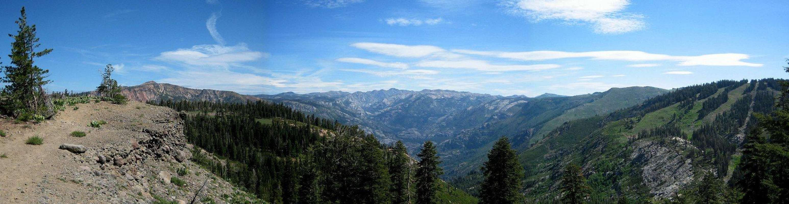  |
Corral Ridge straddles the Calaveras and Alpine county lines and by default happens to be the former's highest point. Topographic maps indicate that Corral ridge stands 8,170 feet tall. There is, however, a point located slightly south that includes the 8,160 foot contour lines and may be slightly higher. Due to these inconclusive elevation readings, the faithful county highpointer should visit all potential highpoints.
 Possible alternative highpoints located to the South of Corral Ridge.
Since the southern potential highpoints are mostly shrouded in trees, this page covers the more prominent (and marked on topo maps) northern highpoint. Indeed, Suttle, in his excellent book "California County Summits" refers exclusively to the northern point.

Getting There
Corral Ridge can be accessed via a network of OHV trails beginning near the small resort town of Bear Valley on Highway 4. Specifically, the trailhead is located about 3/4 of a mile west from town on the north side of the highway.The hike meanders along Corral Gulch for the first mile or so then climbs steeply to the ridgeline. Since the trail follows active jeep roads, expect them to be very dusty. As such, a weekday visit may be preferred in order to avoid crowds (not that there are that many people in the area).

Once the ridge is gained turn left and continue following the obvious jeep trail, eventually passing through a barbed wire gate. The southern highpoints are located to the west of the gate. After trouncing around in the woods looking for a possible highpoint (and register), head north back to the jeep trail. Shortly after, leave the trail to the obvious point comprised of volcanic rock.
Red Tape
Corral Ridge lies within the Stanislaus National Forest. Campfire permits are required. Otherwise there are few restrictions.Calaveras Ranger District
P.O. Box 500
(Highway 4)
Hathaway Pines, CA 95233
(209) 795-1381
FAX (209) 795-6849
TDD (209) 795-2854
Stanislaus National Forest
19777 Greenley Road
Sonora, CA 95370
(209) 532-3671
FAX (209) 533-1890
TDD (209) 533-0765
Camping
Campground Information| Campground | # of Sites | Fee | Water | Toilets | Elevation | Comments |
|---|---|---|---|---|---|---|
| Lake Alpine | $20.00 | Piped Water | Flush | 7,300' | June to October, weather permitting | |
| Hermit Valley | No Fee. first-come first-served | None | Vault | 7,100' | Walk-in sites | |
| Mosquito Lakes | $5.00 | None | Vault | 8,260' | June to October, weather permitting July | |
| Pacific Valley | No Fee. first-come first-served | None | Vault | 7,600' | June to October, weather permitting July |
Information on camping can be found at the Stanislaus National Forest- Camping website.