
|
|
Mountain/Rock |
|---|---|
|
|
46.08711°N / 113.0963°W |
|
|
Hiking, Scrambling |
|
|
Spring, Summer, Fall, Winter |
|
|
10607 ft / 3233 m |
|
|
Overview
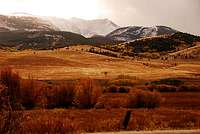
Mt Haggin is a 10,607 foot peak overlooking the little city of Anaconda, Montana, on the west slope of the Great Divide. It was named for a principal in the Anaconda Copper Mining Company, James Ben Ali Haggin. Like most of the peaks in the area, you can bag it by scrambling--no technical climbing required.
Getting There
-To approach from the town of Anaconda take Highway 1 into town to Evergreen st. turn right if coming from West and left if from East. Continue to end of road to Stumptown Rd.
-Park in church parking lot (46.08.09.39N, 112.15.12.95W) on west corner near Fifer Gulch. I did this in winter and this was the logical place to park because the access road is gated. There is a warning sign saying no camping at Hearst Lake. I along with many others have though with no trouble.
-From the church(5,430ft) hike 1.5 miles on road until jct. and tree line. Continue going straight on road.
-Continue on the old forested road 4.1 more miles to Hearst Lake.
-From the west side of the lake follow the faint trail .6 miles to the prominent NE gully(8720ft) that separates Hearst and Haggin Lakes. There is a wire cable that parallels the trail.
-Continue 1 mile on the rounded ridge to the summit.
-Return the way you came
14.4 miles roundtrip with 5,150ft. of elevation gain
-The other approach is made from a subdivision on the east side of the mountain near Mill Creek.
-The road winds high up the ridge to tree line (four wheel drive is needed). Park and follow the trail along the ridge to the summit.
Red Tape
There is a sign stating you are not allowed to camp at Hearst Lakes. Stay on access road and trails because there is private land nearby.
Camping
Long day hike. So I recommend camping at Hearst Lake (there is a sign at the trailhead saying not to camp there) or at tree line near an old cabin(8,800) between Hearst lake and the pass towards Haggin Lake. This is probably the safer choice.
Flora and Fauna
Trees:
-Aspen and Lodgepole make up he lower treeline.
-The upper treeline is dominated by Alpine Larch (Larix lyalli), a graceful, slow-growing, long-lived conifer that loses its soft, feather needles in fall-winter.
-Sadly, the other dominant tree -- Whitebark Pine (Pinus albicaulis) -- are dying out, killed by a blister rust
Whitebarks are being considered for an Endangered Species Act listing. Their cones bear pine nuts and are an important food source for black and grizzly bears.
It's happened before. The subalpine area is dotted with the skeletons of other great trees killed by a human-introduced pathogen c. 1900. How much of our ecosystem can we afford to destroy?
Flowers:
-The hike in traverses a mile or so of parkland, with Blanketflowers (Gaillardia aristata)
-As you enter the lower treeline of aspen and lodgepole (where there it's higher with more moisture than the parks), there are Woods Rose (Rosa woodsii)
-Yellow Columbine (Aquilegia flavescens; some with a pink tinge)
-Along the woodland creeks, Mountain Bluebells (Mertensia ciliata)
-And in the scree, Mountain Gooseberry (Ribes montigenum)
-Alpine Lousewort (Pedicularis sudetica var scopulorum; ugly name, gorgeous flower)
-Cushion Phlox (Phlox pulvinata)
-Mountain Sorrel (Oxyria digyna)