
-
 29396 Hits
-
 81.84% Score
-
 14 Votes
|
|
Mountain/Rock |
|---|---|
|
|
50.33434°N / 125.84061°W |
|
|
Hiking |
|
|
Spring, Summer, Fall |
|
|
5479 ft / 1670 m |
|
|
Overview
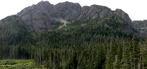
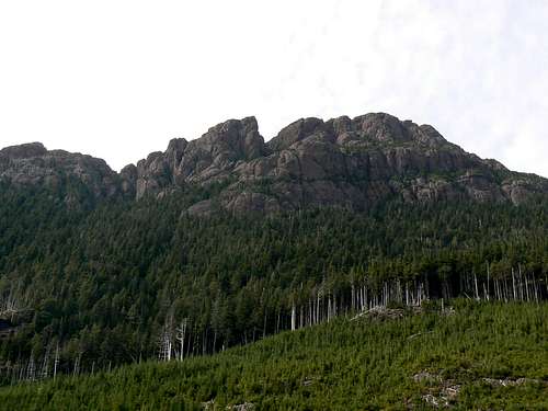 H'kusam Mountain east aspect H'kusam Mountain east aspect |
H’kusam is the scene of the annual 23 km endurance challenge known as the “Kusam Klimb” which is itself a result of the building of “Bill’s Trail”.
Bill West-Sells is a resident of the village of Sayward who, in 1989, needed to bring water to his rural property. So he built a trail up the west side of H’kusam from his property until he found a suitable source, installed the waterline and then – just kept on going. Thirteen years later and with the help of many forward looking local people, Bill’s Trail was finally finished! From Sayward it climbs to a ~1,500 metres col to the north of H’kusam and then descends the north branch of the Stowe Creek watershed to a debuilt system of logging roads which can be used to return to the starting point.
Folks soon began using the astonishingly well built trail and then challenging each other to see who could do it fastest. It didn’t take long before the village got hold of the idea and very soon the idea of the Klimb was born and the inaugural event – with the enticement of its now famous slogan "Are you Tough Enough?" - organised in 2003. As the word spreads more and more come every year to what is now an important fixture in the village’s calendar and that of the whole north Island.
Bill’s Trail doesn’t go to the summit of H’kusam but from either the Sayward or Stowe Creek sides it does provide superb access to what otherwise would be a much longer route.
H’kusam Mountain is named for the Walatsumas First Nation of nearby Kelsey Bay.
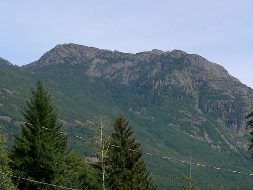
H'kusam Mountain west aspect from Sayward
Getting There
Vancouver Island can be reached directly by air from Toronto, Vancouver, Seattle, Calgary, Edmonton and recently from San Francisco to either Victoria, Nanaimo, Comox or Campbell River and by ferry from Port Angeles to Victoria on The Coho and on BC Ferries from Vancouver to Victoria or Nanaimo. Public transport on the Island is notoriously poor and anyone arriving by air would be advised to rent a car.Approach the mountain from the south on Highway 19 and drive through Campbell River following signs for Port Hardy. Exactly 62 km from the silver bridge over the Campbell River find Timber Road on the right. This gives access to H’kusam from the Stowe Creek side. Carry on past Timber Road for 2.7 km to Sayward Junction and turn right. This leads to the northwest access (and Bill’s house).
For the Stowe Creek trailhead drive onto gravel, up Timber Road 100 metres into the lumber company’s yard and straight out again up the hill on the left. Right after the nice house on the left with the paved driveway is the first water bar. Decide right there and then if your vehicle is up to it because you’ve got 115 on them to cross! Although some sources say that a 2WD vehicle is OK, I personally doubt it. If you want to get all the way to the trailhead I would consider a 4WD vehicle with high clearance as mandatory.
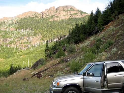 H'kusam Mountain and Stowe Creek TH | 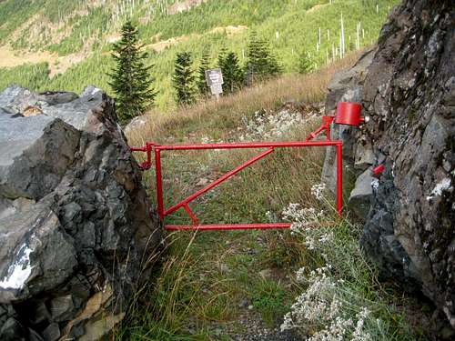 Stowe Creek Trailhead |
For the trailhead for Bill’s Trail in Sayward proceed through Sayward Junction, over the Salmon River and, about 4 km from the highway – just after the Coral Reef pub – turn right and drive up to the well marked car park and trailhead. Elevation here is just about sea level.
Approaches
From Stowe Creek
H'kusam NE aspect from the end of the debuilt roads.
From the parking area walk through the red anti-ATV gate and up the de-built road in a northwesterly direction. Bill et al have made a nice path along the old roadbed as well as a bridge across the north branch of Stowe Creek. Cross the latter and swing SW for 200-300 metres before the track turns north and returns to following Stowe Creek.
Between these legs you reach a marked junction for “Lyle’s Route” which follows a course across the south face of H’kusam before finding a forested gully that leads to the open south ridge and the summit. Bill’s trail, however, sticks to Stowe Creek and the old road as it heads north and then west before petering out in the usual slash pile at about N50 20.392 W125 49.739 and 1,050 metres elevation. Beyond the end of the road the route enters lovely sub-alpine old growth forest on excellent trail.
Almost as soon as you enter the trees you will cross Stowe Creek for the last time – a nice bridge is in place - and find a wood frame tarpaulin covered shelter. I assume that this is a support facility for Klimb participants. It’s equipped with all sorts of emergency supplies and would certainly provide refuge in a storm. Unless you’re in such a storm, please leave everything as you find it.
 Bills/Lyles Trail junction Bills/Lyles Trail junction |  Kusam Klimb shelter Kusam Klimb shelter |  Bills Trail Bills Trail |
From the shelter the trail quality never deteriorates as the route makes its way west and up the valley towards the col that gives access to the Sayward side of H’kusam. For those wishing to summit the mountain, however, the summit route begins before reaching the col.
At the shelter you are already north of the summit and need to get into the narrow north bowl below H’kusam from which a climbable gully leads to the summit ridge. To date I have found two ways to do this.
1. From the shelter proceed west up the valley. The route begins to steepen as it approaches the col and a series of fixed handlines appear on the route. These are to assist the Klimbers who may be running down steep snow at this point.
 Bottom of the Klimb handlines Bottom of the Klimb handlines |  Traverse (green) route to the north bowl Traverse (green) route to the north bowl |  The lower north bowl The lower north bowl |
At the bottom of the first rope is an old, barely readable sign – if you can find it. At this point, don’t go up the rope. Instead angle off to climber’s left and out onto an open scree rib. At about N50 20.427 W125 50.568 (about 1295 m elevation) and the mid-point of the rib look due south and locate a steep gully above. There is some flagging about but don’t count on finding it. Head south and up the gully. You should soon find a boot path and more flagging. If the “path” crosses the creek in the gully before continuing up, you’re in the right place. Once out of the bush and into the alpine the way is obvious and continues south into a lower bowl before one last climb into the upper bowl from which the summit gully can be seen.
2. If the above doesn’t appeal, continue up the ropes to about N50 20.481 W125 50.633 – about 150-200 metres map distance below the col. Turn left (south) and make a gradually rising traverse across the foot of the bluffs above and enter the lower bowl this way – about 400 metres map distance from Bill’s Trail. Continue into the upper bowl as above. Option 2 is nothing like as steep as Option 1 but is quite bushy in places.
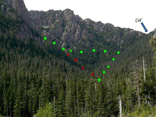
Routes to the north bowl
From Sayward
From the trailhead in Sayward for Bill’s Trail follow the well signed, maintained, obvious and STEEP track up the west face of the mountain. There are viewpoints – particularly at Keta Rock - and even a couple of Bill’s benches to rest on but for the most part – and unless you’re a Klimber, when the leaders make it in under 1.5 hours - it’s a 3-4 hour grunt up to the col.
Once over the col, descend to either of the two options described above and proceed into the upper north bowl.
Summit Route
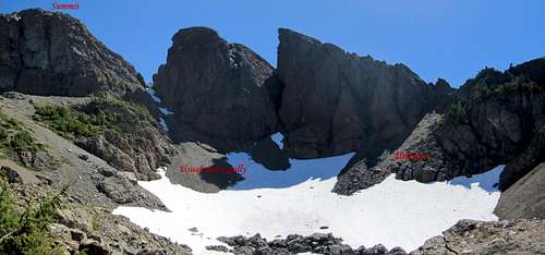
H'kusasam Summit Routes
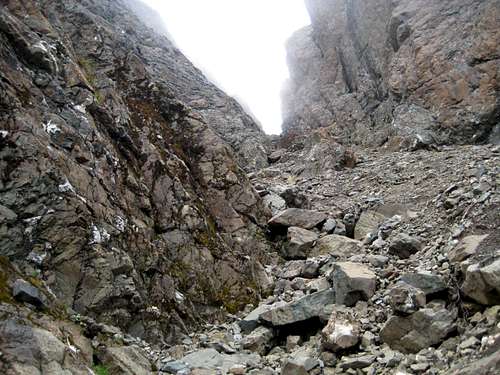
Cross the upper north bowl almost directly below H’kusam’s main summit and head up the leftmost gully. It’s quite loose but not too steep. At about the mid-point a rock step is best climbed on climber’s right. After about 100 vertical metres of climbing you emerge on the open summit ridge, turn left (east) and walk up to the summit in 5 minutes or so.
This gully is often full of rotten, icy snow and is permanently subject to rockfall. If you don't fancy this route, head west up a bit of unpleasant scree and access the summit ridge from there. Hike back southeast across two intervening gullies to the top of the direct gully and to the top from there. Refer to the image above.
The summit is equipped with a summit register, a survey tripod, a Canadian (ie federal) Geodetic Survey Monument (under the tripod) and, very unusually, three witness marks to the north, east and west. Although common in the US, I’ve never seen witness marks in Canada before, never mind 3 of them.
 H'kusam Mountain Summit Ridge Gully | 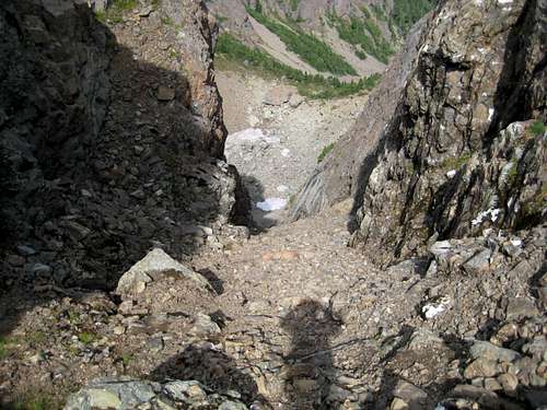 H'kusam Summit Ridge Gully Looking Down | 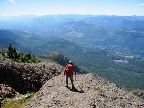 H'kusam Summit Ridge |  H'kusam Summit View W |
A MapSource/Garmin tracklog is available for the asking for the approach and summit routes. Just send me an email or PM.
Approximate route data.
Total distance: up Option 1, down Option 2: ~ 12 km. Add 2 km if you need to take the long way around to avoid the steep gully.
Net elevation: ~ 950 metres
Total elevation: ~1,050 metres
Ascent Time: ~ 3-4 hours
Descent Time: ~ 2-3 hours
  |
Red Tape and Safety Considerations
Absolutely no red tape.There’s nothing resembling an intentions system in this neck of the woods. Make sure, therefore, that you have left a detailed trip plan with someone responsible. The RCMP and the appropriate SAR agency will respond in an emergency but it is up to you to have the mechanism in place that will initiate the call-out process if it becomes necessary.
There is no cellular service anywhere on H’kusam Mountain.
Camping

Fine view if you camp at the TH
Most will tackle H’kusam as a day trip. Nevertheless, you may want to get an early start and a car camp may be called for. If so, the trailhead is a great spot with lovely views down Stowe Creek and west to Victoria Peak. There’s an outhouse and Stowe Creek is not too far away as a source of water. For convenience sake, however, I’d haul a barrel in with you. You could even fire up the old BBQ that someone's left at the trailhead if you’re so inclined.
Useful Links
For more information refer to Island Alpine – A Guide to The Mountains of Strathcona Park and Vancouver Island, Philip Stone, Wild Isle Publications, 2003, ISBN 0-9680766-5-3For general backroad information and directions get hold of a copy of Backroad Mapbook. Volume III: Vancouver Island
Weather
Kusam Klimb
The official Kusam Klimb website
Shane Ruljancich’s site . Shane is a three time winner.