
-
 33609 Hits
-
 83.69% Score
-
 17 Votes
|
|
Mountain/Rock |
|---|---|
|
|
39.75790°N / 105.2082°W |
|
|
Jefferson |
|
|
Hiking |
|
|
Spring, Summer, Fall, Winter |
|
|
6335 ft / 1931 m |
|
|
Overview
Special thanks to SP member
Jeremy Hakes for contributing his photos to this page.
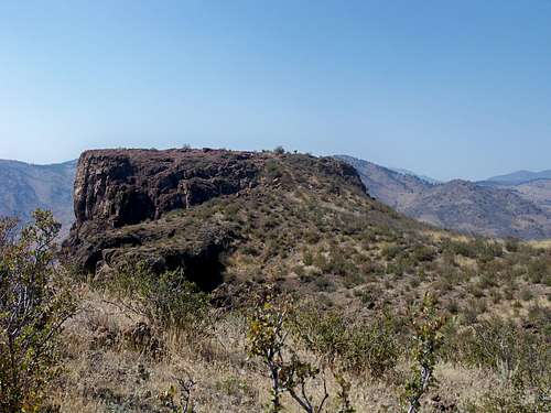
Castle Rock on South Table Mountain
This medium-sized mesa immediately east of Golden, Colorado, rises hundreds of feet above the community and the nearby Coors Brewery. The mesa is capped by basalt is of volcanic origin which forms a cliff-band (dozens of feet high in places) that circles the top of the mountain. South Table Mountain provides a great, close-to-home outing not only for residents of Golden, but for much of the Denver Metropolitan Area, as well.
South Table Mountain and its neighbor, North Table Mountain, are twin landmarks on either side of Hwy 58. They sit in a transition area where the Great Plains rise up to the crumpled land of the Rocky Mountain Foothills. Wildlife you may encounter during a visit includes Mountain Lions, rattle snakes and plains lubber grasshoppers, which virtually shake the ground as they hop by.

Castle Rock, a notable named outcrop jutting westward off of South Table Mountain, provides a commanding view of the Golden Area and the peaks to the west. Castle Rock has an interesting place in Golden history; At one time a funicular swept tourists up to Castle Rock on South Table Mountain’s west side. Click here to visit Golden’s website and learn more about this topic. Ascend the old stairs to Castle Rock and enjoy the fantastic views from this overlook, then backtrack and hit the highpoint northeast of the overlook to claim the summit of South Table Mountain.
Colorado Rank: 4,269th highest peak in Colorado
Prominence: 475 feet
Mountain Range: Front Range
USGS Quad: Golden
Trails Illustrated Map: #100 (Boulder, Golden)
Rank and Prominence Reference: Lists of John
Getting There


The Table Mountains are located in the western foothills of the Denver Metropolitan area, and bounded by the City of Golden and the western communities of Pleasant View, Fairmont, and Applewood. Just ten miles west of the City of Denver, South Table Mountain is easily accessed with Hwy 58 to the north and Interstate 70 to the south.
| Access Point | Special Note | Driving Directions |
|---|---|---|
| Lubahn Trail TH | Limited on-street parking; accesses classic, historic trail built by Prof. Lubahn. | From U.S. 6 in Golden, head east on 19th St. Continue east approximately 10 blocks on 19th Street until it ends at Belvedere St. Park on the road (parking is limited). The trail begins on the south side of Belvedere between 18th and 19th. |
| NREL Visitor Center | Access to less-busy south side of mountain | From Exit 263 on I-70 (Denver West Boulevard) head north toward the Denver West Marriott Hotel. Turn left at the traffic light on to Denver West Parkway. The Visitors Center is the first building on the right past NREL's entrance sign. |
| East Access | Great neighborhood access, but difficult to reach | From I-70, take exit 263 (Denver West Boulevard). Turn right on Denver West Parkway. Head west on W 20th Ave. Turn right/north on Eldridge St. Turn left on Foothill Circle, then left on Old Quarry Road. |
Red Tape
North and South Table Mountain | swm88er

Josh rappelling | Josh Lewwis

Matt leading | Josh Lewis
South Table Mountain has been at the center of a heated effort to protect the mesa as community open space. A checkerboard maze of property ownership exists on top of the mesa, meaning not all of the mountain sits on public land within the Jefferson County South Table Mountain Park. Carry a map that identifies private property on the mesa and respect the owners’ rights.The Jefferson County Open Spaces are fantastic community recreation resources, but visitors are subject to stringent rules. Visit this site (PDF) Jefferson County Open Space Regulations for a comprehensive summary of regulations governing visitor use of these Open Spaces.
And here, for reference, are the standard rules governing use of South Table Mountain Park:
- Follow Alternate Use Schedule
- Dogs must be on a leash; pick up after your pet
- No fires
- No camping
- Motorized vehicles prohibited
- No feeding wildlife
- Adhere to posted Park closures
- Open carrying of firearms is prohibited (which I take to mean concealed carry is fine for those with a permit)
- Park is open one hour before sunrise to one hour after sunset
Camping & Lodging
South Table Mountain is very close to the Denver Metropolitan Area and sits just on the edge of the city of Golden. The vast majority of visitors wishing to summit South Table Mountain will do so as a day outing.


South Table Mountain Open Space
South Table Mountain Open Space is a day-use park only. There is no overnight camping allowed in the park.
Golden
Golden and vicinity provides a decent selection of hotels, even a luxury property or two. Visit this page for more information about hotels, motels and B&Bs in Golden.
Denver
If you can’t find suitable lodging in a city the size of Denver, you must have very peculiar tastes. Visit this page for more information about the variety of lodging options in Denver.
Weather & Seasons
Golden is drenched in sunshine and gets less than 20 inches of rain per year.


Spring: The snow on South Table Mountain will melt out much earlier than the high country to the west. That being said, a fresh spring snowfall on South Table Mountain could render this area a winter wonderland…or a muddy, soggy mess.
Summer: Summer at this relatively low elevation can bring searing heat and blazing sun. Wear a brimmed hat, carry plenty of water and protect yourself from the UV rays. Southern and western exposure on the Lubahn Trail can make an afternoon summer hike feel like a walk through an oven.
Fall: Fall can bring cooler temperatures to South Table Mountain, but the short grasses and desert-like scrub can become drab, brown and prickly this time of year.
Winter: Trails may get packed and icy in the winter. While South Table mountain will hold much less snow than the mountains to the west, a heavy local snowstorm will leave the area covered in snow for a few days. Many days of the winter, however, this area may provide snow-free hiking while the high mountains are buried in powder.