
-
 25467 Hits
-
 88.55% Score
-
 27 Votes
|
|
Mountain/Rock |
|---|---|
|
|
61.31269°N / 149.40443°W |
|
|
Hiking |
|
|
Spring, Summer, Fall, Winter |
|
|
4271 ft / 1302 m |
|
|
Overview
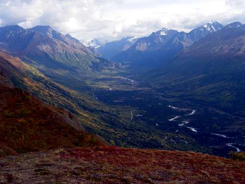
It is tempting to say that the most magnificent thing about Mt. Magnificent is its name. But in truth, this little peak does provide an eye-catching backdrop to the lower Eagle River Valley, especially when decked out in fall colors. From greater distances, it tends to be overshadowed by higher neighbors. The standard hike up provides one of the nicest ridge walks in the Anchorage area.
Views along the ridge walk to Mt. Magnficent
Getting There
Mt. Magnificent is generally climbed from the Mile Hi trailhead in Chugach State Park. To reach it, take Eagle River Road east from the town of Eagle River. Two miles east of the traffic light with Eagle River Loop Road, Eagle River Road, which has been running straight as an arrow to the east, bends southeastward. Instead of following it, continue straight, bearing left onto Mile Hi Avenue. Drive up this and make your way up the switchbacks; there are many street names, but all you need to know is to select the most uphill choice at every intersection. If you prefer a map, there is one in the "Maps" section below.At about the sixth switchback (officially, the end of Lynx Way) there is trailhead on the right, with room for a couple of cars to park by a red gate. Be careful not to block the gate.
Routes
The standard route (west ridge)The trailhead is at 1600 feet elevation. Walk past the gate and continue a few dozen yards to some communication towers. The trail heads uphill to the left of a small fenced enclosure. Seven hundred feet of climbing brings you to delightful Mile High Saddle:
 Mile High Saddle
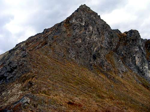 Summit cone
In winter conditions, it often will not be possible to use the steep and avalanche-prone north face; the route to the summit is then up the class 3-4 crest of the west ridge.
Brisk hikers will require a little under two hours for the ascent, but most will prefer a leisurely climb of three hours or so.
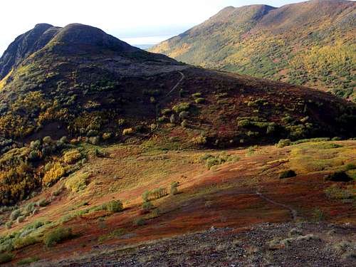
One of the false summits along the west ridge
The net elevation gain from the trailhead to the summit is about 2670 feet, but with the ups and downs of the intermediate summits, most parties will climb about 3400 feet over the course of a round-trip.
Alternative Routes
The east ridge toward Mt. Significant is easily hiked. Judging by the summit register, quite a few people use this ridge as part of a circuit taking in Magnificent and Vista Peak.
Approaching the peak up Meadow Creek is also possible. There is said to be a reasonable trail along the brushy valley floor.
You can access Mile High Saddle via an alternative trail that begins in the turnaround at the end of Eagle River Lane, elev. 1300', and follows the ridge over three summits to the saddle. The ups and downs on this route add about 1000' and one hour to your total ascent, but it is a pleasant walk with lots of views. A few hundred yards above Eagle River Lane, watch for a counterintuitive 90-degree right turn; thereafter the route is pretty obvious.
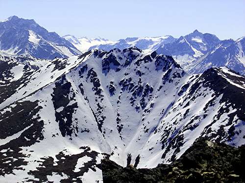
The summit (center) viewed from nearby Blacktail rocks to the northwest in May. The regular route described in the text comes in along the right skyline and then drops onto the north face near the deep, rounded col. But in conditions this snowy, you might be better advised to stay on the crest.
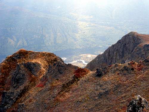
Looking down the south face from the summit
Maps
 Trailhead location--click to enlarge Trailhead location--click to enlarge |
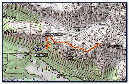 Regular route Regular route |
Red Tape
None.Camping
Backcountry camping is allowed without permits throughout the vicinity of Mt. Magnificent. Gorgeous but waterless tenting sites can be found at Mile High Saddle and along the ridge crest in the first mile beyond the saddle.Magnificence
Mt. Magnificent’s name resulted from a crusade in territorial days by a local woman, Mrs. Ollie A. Trower, who would not settle for a lesser moniker for her favorite mountain. She seems to have made up the name herself. After six years of effort, in which she enlisted the help of the territorial senate, the U.S. Board of Geographic Names gave in to her campaign in 1959.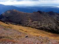
Looking back down the west ridge route from the vicinity of the summit
Magnificence is rare. So far as I can tell, the world has just one other Mt. Magnificent, a much-beloved peak near Adelaide, South Australia. If you stacked these two Mt. Magnificents on top of one another, you still wouldn’t come up with 2000 meters. But, as the Australians would surely agree, size is an overrated attribute.
The other names for Mt. Magnificent are "My Mountain," apparently used locally by some settlers, and the Dena'ina name "K'ulch'ey."
External Links
Metric MapThe other Mt. Magnificent
Which is the most magnificent of all?