

|
|
Mountain/Rock |
|---|---|
|
|
19.49330°N / 97.1483°W |
|
|
Hiking |
|
|
14049 ft / 4282 m |
|
|
Overview
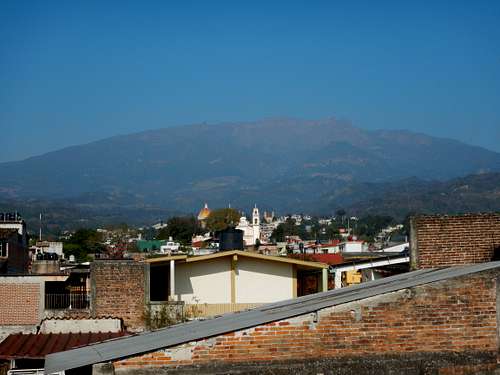
El Cofre de Perote or Nauhcampatépetl is an extinct volcano in the Mexican state of Veracruz and depending on the source is either the seventh or eight highest peak in Mexico. According the latest INEGI survey, it has an altitude of 14,049 ft or 4282 meters, and a prominence of 4435 feet or 1354 meters. It is located where the Cordillera Neovolcanica that strechtes west to east in central Mexico joins the Sierra Madre Oriental that goes all the way up into northeastern Mexico.
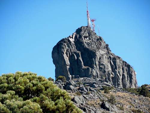
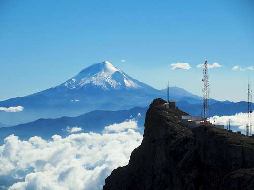
This volcano got its name from the volcanic outcropping that constitutes its peak which resembles a steep four-sided box or "cofre" (cofre is also the name for coffin). Its original, indigenous name in Nahuatl, ‘ Nauhcampatépetl’, means ‘four-sided mountain’, thus also referring to its shape. Unfortunately the summit is nowadays covered with antenna's that do take away some of the 'cofre's' beauty.
El Cofre de Perote lies within the 'Parque Nacional Cofre de Perote', which was established in 1937. It is an extinct shield volcano, which gives it a rather broad profile and therefore doesn’t really match the popular stereotype of a volcano. Because of this and its close proximity to other, more famous Mexican volcanoes such as El Pico de Orizaba, El Cofre de Perote is often overlooked by many. Even so, it the mountain makes for a nice hike and day out.
It still makes for an easy and pleasant day-hike that takes you for the bigger part through a pine forest with great views of the surrounding volcanoes on clear days and could make for an easy acclimatization climb for those planning to climb neigbouring volcanoes. Cofre de Perote has one of the best views of Orizaba that you can find.
Getting There
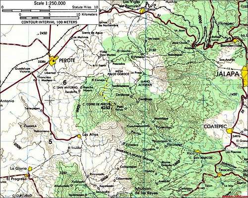
The first desitination is Perote (2400 meters) located in the Mexican state of Vericruz. Perote is about 265km east from Mexico City, and about 130km from Puebla on highway 140 towards Xalapa. Buses run several times a day from Mexico City, Puebla and Xalapa. Perote itself is a rather sleepy town, in contrary to Xalapa, the capital of Veracruz. All buses to Xalapa from places like Mexico City or Puebla pass through Perote.
From Perote, there are several access routes to El Cofre but the one most commonly used is via the village of El Conejo (3250 meters). Buses to El Conejo only run every three hours, the last one at 7pm, so taking a taxi from Perote is often more convenient.
The village of El Conejo has only one entrance road, the bus making a turn at the church before heading back to Perote. There are no hotels in El Conejo so you might choose to stay in Perote and take an early taxi in the morning. If you do end up in El Conejo you can ask in the grocery store ‘Miscalleanea Lizbeth’, right in front of the first bus stop as you enter the village, where they rent out some basic rooms for the night and can prepare you a meal although it is not really advertised. Also ask here about buses going back to Perote as there are no taxi's in the village.
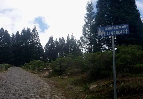
To get to the trailhead turn right as you enter the village (turn left to get to the church) and after a couple of minutes you will see a blue sign indicating the way to the ‘centro recreativo’. From this sign, the rocky paved road takes you all the way to the base of the summit block, in 3 to 4 hours. If the weather allows you could actually drive a high clearance vehicle to the base of the block. You’ll reach the ‘Centro Recreativo’ in 30-40 minutes up from the trailhead.
Routes Overview
Via El Conejo
The most popular way to the base of the summit block is to walk or drive the cobblestone road from El Conejo.
If you are on foot and you don't want to walk the cobblestone road from El Conejo, there is a trail for most of the way. If you are on foot, this is a better route than walking the road up. In some places, there are several paths, but in one long section, the trail stays east of the road and is marked with arrows and a descent sign near the lowest radio tower. It appears that part of the trail was at one time built for mountain bikes, but it doesn't show any signs of recent mountain bike use.
Thankfully, you can't actually drive to the summit of the Cofre. The steep summit block has a steep concrete and handrail route to the summit, which you must climb.
If staying in Perote, plan on on all day hike, including travel time to and from El Conejo.
It is also possible to climb the Cofre all the way from Perote on foot as a trail exist to El Conejo, but this is a very long day for most.
Technical Climbing
There are also several trad and sport rock climbing routes on the summit block.
Other Routes
For a real adventure, you might attempt to climb Cofre de Perote from the east. That side of the mountain is much more rugged and scenic, though more difficult to reach as well. There are several deep gorges and slot canyons to the east of Cofre de Perote. There are also some villages which still don't have roads to them.
Camping
There is no water on the mountain, but there are several possible campsites. Please leave a clean campsite.
A ‘centro recreativo’ is also under construction as of 2017, at about 30-40 minutes from the trailhead, with several cabins to stay at but it might take some time to finish.
The mountain is easy to climb in one day from El Conejo however, so you can stay in Perote.
When to climb
Because of the cobblestone road, El Cofre de Perote can be climbed all year round. During the rainiest season, roughly June through September rains can be heavy and the mountain tends to be very wet.
November through April is the best time to climb. There are occasional snowstorms during this season, but sunny skies predominate, though mist is very common.
Red Tape
There is no red tape here so please take care of the area.
Mountain Conditions
Weather averages for summit of Cofre de Perote are below. Since mist is counted as a rain or snow day, there is more sunshine than the weather record below indicates.
CLICK HERE FOR WEATHER FORECAST
| Month | High (° F ) | High (° C) | Low (° F ) | Low (° C) | in. Rain | mm Rain | Rain or Snow Days |
| Jan | 36 | 2 | 28 | -2 | 1.62 | 41.2 | 22 |
| Feb | 41 | 5 | 33 | 1 | 1.74 | 44.2 | 22 |
| Mar | 43 | 6 | 33 | 1 | 1.76 | 44.7 | 29 |
| Apr | 45 | 7 | 37 | 3 | 2.43 | 61.7 | 27 |
| May | 47 | 8 | 41 | 5 | 3.96 | 100.7 | 28 |
| Jun | 44 | 7 | 38 | 4 | 14.17 | 360.0 | 29 |
| Jul | 43 | 6 | 36 | 2 | 16.62 | 422.2 | 29 |
| Aug | 45 | 7 | 37 | 3 | 15.65 | 397.6 | 30 |
| Sep | 44 | 7 | 38 | 3 | 16.81 | 426.9 | 29 |
| Oct | 43 | 4 | 36 | 2 | 7.87 | 200.0 | 29 |
| Nov | 42 | 3 | 34 | 1 | 2.72 | 69.0 | 20 |
| Dec | 40 | 2 | 31 | 0 | 2.13 | 54.1 | 21 |