
-
 8083 Hits
-
 70.87% Score
-
 3 Votes
|
|
Mountain/Rock |
|---|---|
|
|
42.03906°N / 74.54923°W |
|
|
Ulster |
|
|
Summer |
|
|
3868 ft / 1179 m |
|
|
Overview
(IMPORTANT: PUBLIC ACCESS TO THIS PEAK HAS BEEN LOST TO OVER USE, AND ABUSE OF THE OWNERS GENEROSITY, UNTIL THEIR IS A AGREEMENT WITH THE OWNERS IN THE FUTURE YOU MAY NOT HIKE THIS PEAK, AS IT IS PRIVATE PROPERTY. THE CATSKILL 3500 CLUB HAS SUBSITUTED MILL BROOKE RIDGE AS THE 3500 HIKE FOR THE PATCH)
At 3868 feet Graham is the 7th highest Catskill peak and 59th highest in new york state in front of better known mountains such as Hurricane, Gore, Blue, and Wittenberg mountains. Unlike many Catskill peaks graham actually has a know elevation, as it was a home to a Radio Station (the type for communications) back in the cold war era. Graham is one of 2 Catskill High peaks on Private Property (the other is Doubletop), however by calling the caretaker you get clearance to climb the peak. The western Side of graham Mountain has views to Panther, Doubletop, and such. on the eastern side their is cliffs if your willing to search to catch a view of Balsam Lake mountain. The Trail to Graham is an old abandoned road (in the past used to service the radio station, now used as a state snowmobile trail in the winter)that twist its way to the top at a moderate grade. This trip will take about 3 hours round trip from the Dry Brooke junction. This Road comes off of the Dry Brooke Trail .1 mile past or before the balsam lake Trail depending on which way you come up(in the winter do not try to come up the beaver kill road and hike in that way, you will be sorry). You know you've found the summit when you find the old Station.
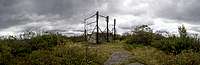 The Radio Station
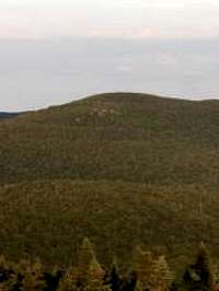 Different view of graham
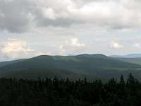 Graham and Doubletop
Getting There
The Northern Trail head is off of the mill Brooke Road near Seager (turn off of 28 onto the dry Brooke road, on your left mill Brooke road will turn off) and the southern Trail head is off of the beaverkill road Out of Livingston manor (just past the covered bridge park on old 17) Booth Approaches will run you about 7.5 miles round trip without balsam lake mountain, with balsam lake mountain plan about 9 miles and probably 8 hours
Red Tape
The Top is on private property, the owners are good about hikers, but Respect them so we can continue climbing this peak BILL FIEDLER 607-221-1277
Call if you wish to climb, large groups each member has to call, bill will be onsite to enforce the rules. If you dont call you may get a ticket or go to jail.....
No camping, no fires, leave no trace... groups must be 10 or under, stay on the old access road/trail to the summit, if headingnto doubletop from graham stay on the main herd path.... sign into the canester with the name of the leader who called bill, or each member who called him (note the group you were with)
No access to the land in big game and bow season.
If the no call tresapassing continues no one will climb graham and doubletop..... its possable the easement to balsam lake mountian from the north could be lost, which would make that a 20 mile plus winter hike.....
Please do the right thing and call for permission..... its easy to do...... the land is private, it always has been private, this has always been the rule
Camping
Camping is exclusively at the balsam lake lean-too, or over in that direction no camping on graham what-so ever
External Links
http://www.catskillhiker.com/peaks/graham.shtml http://www.catskill-3500-club.org/catskill-peaks/graham-mountain.htm