
-
 18846 Hits
-
 81.84% Score
-
 14 Votes
|
|
Mountain/Rock |
|---|---|
|
|
51.69189°S / 58.83397°W |
|
|
Hiking |
|
|
Spring, Summer, Fall, Winter |
|
|
2316 ft / 706 m |
|
|
Introduction
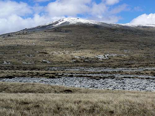 Mt Usborne west aspect from the Usborne/Canterra saddle
 |
Usborne is a rather unprepossessing, flat topped mountain. Rather bland in comparison to some of its lower cousins with their characteristic wind scoured quartzite ridges and corries. Nevertheless, if you’re peak bagging in the Falklands and, even if only because it’s the highest point, you just have to climb it. In fact there are some nice stone runs on just about every side and a glacial cirque and tarn below the summit plateau to the north that offer additional attraction.
The mountain is found at the west end of the Wickham Heights, the west/east arc of high ground between San Carlos Water and the low hills just outside the Island’s capital, Stanley.
If the weather cooperates summit views encompass the whole mountainous north part of East Falkland, the pancake-flat Lafonia Plains in the south and across Falkland Sound to West Falkland Island where Mt Maria, the Islands’ third highest peak, is often visible more that 50 km away.
As with all Falkland Islands hikes be aware that “summer” weather includes sunshine one minute and a snowstorm/white-out the next. The mountainsides are bare and open to the wind with limited possibilities for shelter in an emergency. Carry clothing appropriate to the severe and changeable conditions.
Darwin made two trips to the Falklands and Mt Usborne is named for Alexander Burns Usborne, Master's Assistant on the Beagle.
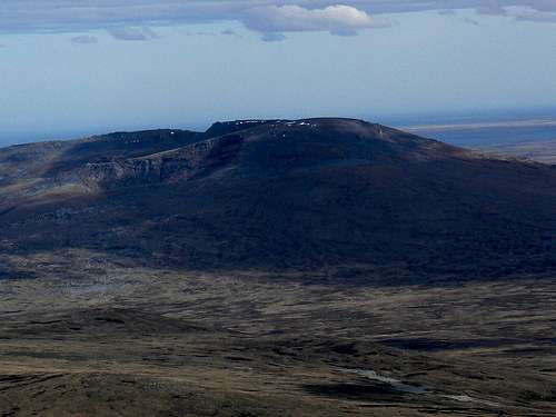
Mt Usborne northwest aspect from the air
Getting There
Reaching the remote and – at least by independent travelers – infrequently visited Falklands is covered in the Falkland Islands parent page.Mt Usborne can be easily visited as a day trip from Stanley. Car hire is readily available in town but be aware that you will be required to agree not to drive across “Camp”. Getting “bogged” will result in a large penalty as well as providing locals with multiple opportunities to dine out on their stories of how and from where they dragged you out! Public roads don’t get too close to Usborne so, unless you have access to a private 4WD vehicle, be prepared for a longish approach hike.
From Stanley drive about 50 km towards the Mt Pleasant airport and turn right at the sign for Goose Green. Drive about 35 km to a signed junction where the roads to San Carlos (don’t confuse this with Port San Carlos) and Goose Green diverge and turn right. Drive towards San Carlos for about 5 km to S51 45.619 W58 56.089 and look for a faint track on the right. This is the limit of driving for a rented vehicle. The mountain is in plain view from here.
If you’re staying at San Carlos it’s 24 km from the settlement to the point at which you leave the road.
The Route
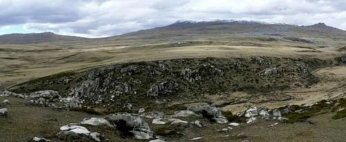
Usborne Canterra Saddle
 Canterra Mountain
 |  Approaching summit plateau
 |  Mt Usborne summit
 |  Mt Usborne summit view west
 |
From the Usborne/Canterra saddle turn right (east) and head up boggy ground at first, then more steeply through loose quartzite boulders and finally onto the broad, featureless summit plateau. Once on flat ground, walk 400-500 metres ENE to the large summit cairn. There is also a register to sign if you can find it. Unfortunately we couldn’t – it was buried in snow.
Descend the same way you went up.
The rather tedious approach hike can be shortened if you have access to an off-road vehicle and have the necessary skills to operate it. Ask your tour operator or, if you’re staying at San Carlos or Darwin ask the folk there for advice. If a few quid saves 10-15 km of unnecessary walking, especially in bad weather, I’d consider this a good investment.
Red Tape
All land in the Falklands is privately owned. Any activities you undertake must be with the permission of the local landowner. Check with whoever you’re staying with in San Carlos, Darwin or Stanley regarding access permission.Close all gates and don’t disturb the sheep.
Accomodation
In Stanley itself you will find the whole range of accommodation options from comfortable hotels to well appointed B & B’s. Use this Falklands Tourist Board link. to start your search.Closer to the start point of the hike you will find excellent lodge-style accommodation at Darwin House. Telephone +(500) 31313, email darwin_house@cwimail.fk or a self catered cottage on the grounds of Kingsford Valley Farm in San Carlos itself. Telephone +(500) 32233, email kvf@horizon.co.fk
I would imagine that camping would be allowed by any cooperating landowner in San Carlos or Darwin but you should check ahead first.