
-
 25616 Hits
-
 85.87% Score
-
 21 Votes
|
|
Mountain/Rock |
|---|---|
|
|
36.06187°N / 79.12156°W |
|
|
Orange |
|
|
Hiking |
|
|
Spring, Summer, Fall, Winter |
|
|
867 ft / 264 m |
|
|
Overview
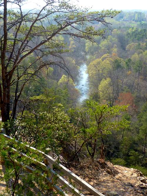
Eno River from Panthers Den overlook
Occoneechee Mountain is the most dramatic summit in North Carolina east of the Uwharries. Ten miles west of Durham, it rises a steep 350 feet directly above one of the piedmont’s prettiest and most pristine rivers, the Eno.
When I was a young boy growing up in Raleigh, the ultimate thrill was a drive to the North Carolina mountains, full of anticipation of the peaks that would be climbed. And as the car sailed westward on I-85 I would always peer out the back window to catch a glimpse of Occoneechee’s hilltop fire tower—the first soul-stirring foretaste of the greater mountains to come.
When I was 14, my family moved to Hillsborough, and my first project was to set out on my bicycle in search of the summit I knew, from those Interstate views, must be somewhere southwest of town. I found Eno Mountain Road, with its promising name, and pedaled upward. Near the top of a rise, a little path led into the bushes, and I followed it. To this day I remember the sudden discovery: Mountain laurel! Cliffs! A real mountain trail, right in my own hometown!
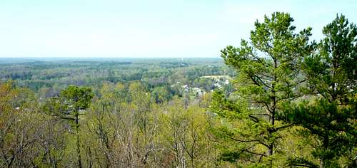
Eastward from the vicinity of the summit
In those days, Occoneechee Mountain was a forgotten corner of the county, largely unappreciated and vulnerable to development. Today, it is a protected natural area with a steadily improving network of nicely-designed trails.
Getting There
The mountain is located by Exit 164 on Interstate 85. To reach the trailheads from the exit, use the map below. If you click on it, then click again, it will expand.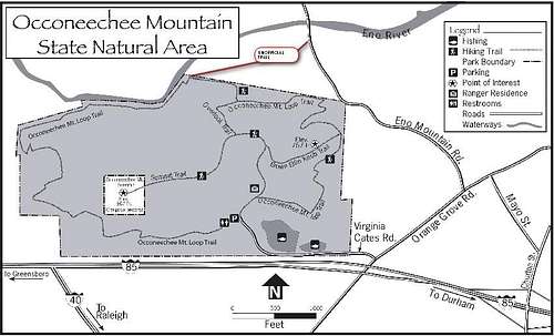
Routes

On the trail shortly after leaving the Eno Mountain Rd trailhead
From Eno Mountain Road: My favorite way to climb this mountain remains similar to the one I first discovered. From Orange Grove Road, follow Eno Mountain Road over a little pass and down toward the Eno River. At the south end of the river bridge, there is gravel parking on either side of the road. A well-traveled unofficial trail leads westward from the end of the guardrail. This path traverses private land, but at this writing it is unposted and hiking is not discouraged. After about three tenths of a mile you will cross onto state park land and reach a junction with the Occoneechee Mountain Loop Trail. Turn left and climb wooden stairs, followed by steep trail, to a rocky overlook above the “Panthers Den,” an old quarry, which affords the best view on the mountain. After enjoying this, follow the trail behind you about 100 yards southward to a gravel road; turn right (west) and ascend gently another 0.4 miles to the summit towers. The total one-way distance covered on this route is about a mile.
Via Loop Trail: From Orange Grove Road, take Virginia Cates Road to the official parking area for Occoneechee Mountain State Natural Area.

Summit towers

The Loop Trail along the Eno River
Via Summit Road: From the official parking area for Occoneechee Mountain State Natural Area, follow signs for the summit which will lead you 0.6 miles up a gently-rising gravel road. Because this route climbs the gentler side of the peak, you will miss some of the mountain feel enjoyed on the other two routes. 2012 update: There's now a variant on this route, using the new "Chestnut Oak Trail." Click on the map to go to the map page for details. This variant still lacks the mountain feel of the other routes.
Flora and Fauna
The cool northern slopes support mountain laurel and rhododendron communities more typical of the mountain west than the piedmont. There is also an ice age remnant population of the brown elfin butterfly, otherwise found only at higher elevations much farther to the west.History

Sauthier's Map. Click to enlarge.
The mountain is named for the Occaneechi Indian tribe, who had a village a short distance below it in the Eno River. It impressed early colonists and figured prominently on Claude Joseph Sauthier’s 1768 map of Hillsborough.
In later years, the northeast peak of the mountain (east of Eno River Road) was sacrificed to a strip mine for pyrophyllite, a talc-like mineral used in ceramics, refractors, joint compounds, paint, and other products.
The North Carolina Division of Parks and Recreation began building a natural area around the mountain in 1997, which has gradually grown to the present 190 acres.
Links
Occoneechee Mountain State Natural AreaEno River Association
Occoneechee Mountain Geology
Historic Hillsborough
Upper Neuse River Basin Info
Dangers

| 
|

| 
|
Some of these dangers may be just a little overstated, but the signs are correct that the rock in the old quarry is extremely rotten and not suitable for climbing. The summit fire tower is fenced off and is likewise no longer safe.
Training Opportunity
A few years ago, while I was training for the Alaska mountain running circuit, I had to spend a few weeks near Hillsborough tending to a parent’s illness. I worried that I would lose all my conditioning for steep climbing. Occonechee proved my salvation. The portion of the trail from the river’s edge to the Panthers Den overlook provides a short, sweet 200-foot rise. Do this five times almost as fast as you can, trotting down in between, and you will have discovered one of the most effective interval workouts available. A dozen of these sessions spread over a month will enable you to bound up the steepest grades on your mountain vacation, I promise!