
-
 20103 Hits
-
 86.37% Score
-
 22 Votes
|
|
Mountain/Rock |
|---|---|
|
|
47.42327°N / 121.49139°W |
|
|
King |
|
|
Scrambling |
|
|
Spring, Summer, Fall |
|
|
5566 ft / 1697 m |
|
|
Overview
West Granite Mountain (also known as "Tusk O'Granite") is the high point on the ridge to the northwest of Granite Mountain in Washington's Alpine Lakes Wilderness. As an objective, it is just as worthy as Granite Mountain itself, being only some sixty-three feet lower than its better known neighbor. West Granite will provide views just as spectacular as Granite, but without the massive crowds that Granite Mountain can attract. Indeed, the ascent can be considered much more aesthetic than an ascent of Granite, which is normally accomplished either by way of a trail or up steep ravines. Instead, to climb West Granite, one hikes past two sub-alpine lakes and begins an off-trail ascent through stands of Douglas Fir into a sub-alpine basin, then to a high ridge which will lead you to the summit. This mountain is especially enjoyable in early season as either a snow-shoe excursion or skiing trip, when you should have this mountain all to yourself. At the summit, enjoy unsurpassed views of Chair and Kaleetan Peaks, as well as mountains all the way to Lemah, Chimney Rock, and Mount Stuart.
A scramble of West Granite is easily combined with one of Granite, making a natural two-fer and a great loop trip. A very easy ridge connects the two mountains, with only a drop of 400 vertical feet when traversing from one to the other.
![Sunrise from West Granite]()
![Climbing above Olallie Lake]()
Climbing above Olallie Lake ![Kaleetan and Chair Peak from West Granite]()
Kaleetan (left) and Chair Peak (right) from West Granite You can approach West Granite from two different trailheads. For a shorter hike and less elevation gain (but a harder drive on your car), take I-90 East from Seattle, exiting at Exit 45. Go under the freeway and take Road 9030 West one mile to a fork. Take the higher right fork and drive another 2.5 miles to the road end. The elevation here is 2600 feet. The last time I visited these roads, they were nearly impassable due to potholes and road damage. If able to reach the road end, hike the trail an easy two miles to Olallie Lake.
Or, for an easier drive, take I-90 East from Seattle, getting off at Exit 47. From the ramp, turn left over the freeway, and at the "T" turn left 1/4 mile to the parking area for the Granite Mountain Trail (Elevation 1875 feet). Hike the Granite Mountain trail, hiking about 3/4 of a mile and gaining 700 feet to a junction at 2600 feet. The right fork heads up Granite Mountain. Instead, take the left fork (the Pratt Lake Trail). Hike a further 2.5 miles to above Olallie Lake. From here, the two routes converge. Leave the Pratt Lake trail here (elevation 3,900 feet) and head Northeast through open forest to a basin. Climb to the head of the basin and reach the South Ridge of West Granite Mountain at just over 5100 feet. Climb the easy ridge to the East to the summit of West Granite Mountain, 5,566 feet. The summit of Granite Mountain can be seen 3/4 mile to the Southeast, and is an easy traverse to the lookout there.
Difficulty: Class 2. Distance: About 7 miles roundtrip. Elevation Gain: 3000 feet from the Talapus/Olallie Lake Trail, or 3700 feet from the Granite Mountain trailhead.
A scramble of West Granite is easily combined with one of Granite, making a natural two-fer and a great loop trip. A very easy ridge connects the two mountains, with only a drop of 400 vertical feet when traversing from one to the other.
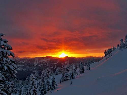
Sunrise from West Granite. February, 2017. Courtesy awilsondc.
- Getting There

Climbing above Olallie Lake

Kaleetan (left) and Chair Peak (right) from West Granite
Or, for an easier drive, take I-90 East from Seattle, getting off at Exit 47. From the ramp, turn left over the freeway, and at the "T" turn left 1/4 mile to the parking area for the Granite Mountain Trail (Elevation 1875 feet). Hike the Granite Mountain trail, hiking about 3/4 of a mile and gaining 700 feet to a junction at 2600 feet. The right fork heads up Granite Mountain. Instead, take the left fork (the Pratt Lake Trail). Hike a further 2.5 miles to above Olallie Lake. From here, the two routes converge. Leave the Pratt Lake trail here (elevation 3,900 feet) and head Northeast through open forest to a basin. Climb to the head of the basin and reach the South Ridge of West Granite Mountain at just over 5100 feet. Climb the easy ridge to the East to the summit of West Granite Mountain, 5,566 feet. The summit of Granite Mountain can be seen 3/4 mile to the Southeast, and is an easy traverse to the lookout there.
Difficulty: Class 2. Distance: About 7 miles roundtrip. Elevation Gain: 3000 feet from the Talapus/Olallie Lake Trail, or 3700 feet from the Granite Mountain trailhead.
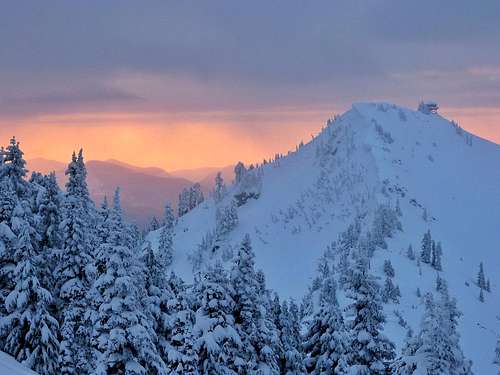
Granite Mountain at Sunrise. February, 2017. Courtesy awilsondc.
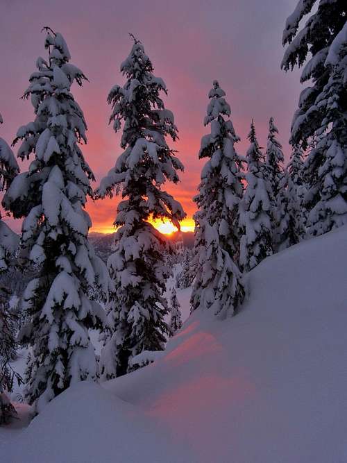
Sunrise Through the Trees. February, 2017. Courtesy awilsondc.
Red Tape & Camping

Traversing to Granite Mountain from West Granite

Reaching summit of Granite Mountain from West Granite Mountain
Camping sites are numerous around both Talapus and Olallie Lakes. These are probably the only practical camping areas on this trip.
External Links

Kaleetan from summit of Granite Mountain

Summit of Granite Mountain
North Bend Office
42404 SE N. Bend Way
North Bend, WA 98045
(425) 888-1421
Snow conditions are available from the Summit at Snoqualmie Ski Areas (of which Alpental is one) at the following website:
Summit at Snoqualmie Snow Conditions
Also, webcams are available from the Washington State Department of Transportation at:
Snoqualmie Pass Web Cam