
-
 26381 Hits
-
 81.18% Score
-
 13 Votes
|
|
Mountain/Rock |
|---|---|
|
|
34.48670°N / 84.34034°W |
|
|
Pickens |
|
|
Hiking |
|
|
Spring, Summer, Fall, Winter |
|
|
3288 ft / 1002 m |
|
|
Overview
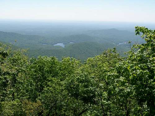
Mount Oglethorpe has major historical significance. It served as the southern terminus of the Appalachian Trail from 1937 - 1958. In 1958, development around the mountain forced the relocation of the trail end 20 miles northeast to its current location, Springer Mountain. The mountain is named for James Oglethorpe, who founded Savannah and the colony of Georgia in 1733. A monument to James Oglethorpe was originally on the peak. It has since been moved to the nearby community of Jasper.You can drive to within about 0.5 miles of the peak before reaching a barrier. From there, it is an easy hike with modest elevation gain up a gravel road to the summit. The summit is covered with a fenced in area containing several communication towers. Just to the south of the summit is a wooden observation deck. This gives tremendous views to the south on a clear day. The Atlanta skyline was visible on the day of our visit, at a distance of at least 60 miles.
I am not very familiar with the area. I will appreciate comments and corrections to incorporate into this page. Thanks.
Getting There
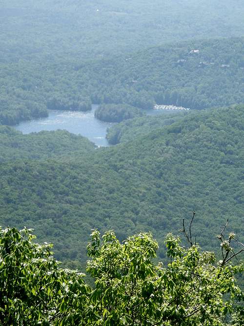
Getting there is much of the challenge and half the fun. See red tape below.From the south: Take GA Route 53 to Steve Tate Road. Drive north until you reach the North (second) entrance of the Big Canoe Resort. Proceed through the gate. Take Wilderness Trail W for about 2 miles. Note the great view of Mt. Oglethorpe near the Lake Petit dam. This photo is taken from near the dam.
After about 2 miles, turn left on Petit Ridge Drive. Continue for about 1.7 miles. Turn left on Sanderlin Mountain Dr. Continue for about 1.1 miles. Continue straight for about 0.3 miles on Deer Run Ridge. Park on the side of the road before you get to the barrier. Note: These are all paved roads until this point. Watch the poison ivy in the woods as you walk around the barrier! Proceed about 100 yards to the road junction. Turn left at the junction and follow the gravel road about 0.5 miles to the summit. You'll pass a second barrier on the gravel road.
From the north (Thanks, Adriana G): Mt Oglethorpe is much more easily accessible via Monument Road which, unlike Big Canoe is not gated. Take Ga 136 from Jasper or 52 to 136 from Dawsonville to Monument Rd. go south for about 2+ miles and then it becomes a gravel road. At the end of the gravel road is a gate stating it is private and as of November 2011, specifically says "No hikers". ( Adriana recently bought a house off of Monument Rd. and plan to send the owner a note requesting permission to go to the summit). Park on the side of the road. Follow the gravel road about 0.5 miles beyond the barrier to the summit. Update 4/30/14 - summit is now public land and open!
There are some very nice hiking trails in the Dawson Wildlife Management area accessed from Monument Rd. with 4 waterfalls on Falls Creek. As of January 2012 access requires a GORP pass which must be purchased in advance. They can be bought online or at retailers http://www.georgiawildlife.com/Georgia-Outdoor-Recreational-Pass.
(Note-Google Maps show the summit to be on Sourwood Circle. From looking at county property tax records it appears that is incorrect. It is at the end of Monument Road.)
Red Tape
Update (4/30/14): Just a quick status update. Eagle's Rest at the end of Monument road is now open. Mountain Stewards have made two very nice walking paths. The shortest one is a 1/2 mile easy walk around the summit. The second path, which is partially completed, will be 2 miles long and more challenging. It is truly a place of rest and meditation. There is currently a deck on the property that faces east. With financial support from the community they plan to add 3 more observation platforms, toilets and an outdoor pavilion/classroom. There are tentative plans for a Summer Solstice celebration on June 21, 2014
http://www.mtoglethorpe.org for details.
This was filmed on Easter Sunday 2014.
http://youtu.be/2eTXf9-5vsg
Well, the red tape is rather substantial from the south. You either have to be a resident or know one. An option exists where you could park at the shopping center on Steve Tate Road (just south of the North Gate), and then either head in via foot or bike. The Big Canoe Resort is an extensive development of vacation homes. For being heavily developed I thought it is very tastefully done with a lot of natural screen hiding the homes and natural areas preserved.
External Links
Wikipedia Entry: HereOther attractions
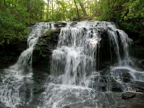
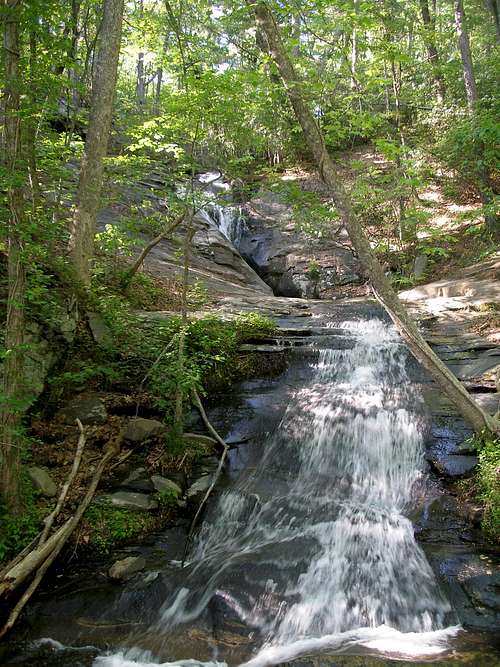
If you gain access to Big Canoe, there is a delightful trail up Disharoon Creek near the base of the mountain. This contains some fine waterfalls.These images are of Lower and Upper Disharoon Falls.
AdrianaG - Mar 12, 2012 5:21 am - Hasn't voted
Better route to Mt. OglethorpeMt Oglethorpe is much more easily accessible via Monument Road whiich, unlike Big Canoe is not gated. Take Ga 136 from Jasper or 52 to 136 from Dawsonville to Mounument Rd. go south for about 2+ miles and then it becomes a gravel road. At the end of the gravel road is a gate stating it is private and as of November 2011, specifically says "No hikers". ( I have recently bought a house off of Monument Rd. and plan to send the owner a note requesting permission to go to the summit). There are some very nice hiking trails in the Dawson Wildlife Management area accessed from Monument Rd. with 4 waterfalls on Falls Creek. As of January 2012 access requires a GORP pass which must be purchased in advance. They can be bought online or at retailers http://www.georgiawildlife.com/Georgia-Outdoor-Recreational-Pass. (Note-Google Maps show the summit to be on Sourwood Circle. From looking at county property tax records it appears that is incorrect. It is at the end of Monument Road.)
Bark Eater - Mar 20, 2012 12:44 pm - Hasn't voted
Re: Better route to Mt. OglethorpeAdriana, thanks. I have posted this information on the main page. Enjoy the GA mtns!
AdrianaG - Aug 21, 2012 5:28 pm - Hasn't voted
Finally made it to Mt. OglethorpeI finally got around to sending Mr. James Powell a note asking for permission to go to the summit. He graciously called me a few weeks later and gave me permission. We drove to the gate about 2.2 miles from the end of the asphalt part of Monument Road and through one open gate to a second gate that was locked. We then walked maybe .2 mile gradual uphill slope to the top. At the summit, as was reported before were a cluster of ugly transmission towers surrounded by equally ugly chain link fences. Off to the right in the woods was a south facing wooden observation deck. The view was as shown in these pictures, but on the hazy day we were there Atlanta was not visible. There were no signs indicating the presence of the AT Terminus at this location. All in all, kind of sad. The property owner of record at this time, per the Pickens County property tax records is Mr. James R. Powell 248 Beason Road Calhoun, GA 30701 He indicated that they had been experiencing increasing problems with vandalism which is why they revised the No Trespassing signs to include No Hikers.
Bark Eater - Aug 22, 2012 6:53 am - Hasn't voted
Re: Finally made it to Mt. OglethorpeGlad you obtained permission and made it to the summit. I will update the main page with the contact info. Thank you.
AdrianaG - Jan 13, 2014 3:31 pm - Hasn't voted
Mt Oglethorpe may be open to the public in 2014We have great news about Mt. Oglethorpe. The owner of >100 acres around the summit has initiated plans for a park at Mt. Oglethorpe which will allow the public access. A groundbreaking/dedication was held in December 2013 but it will not be open to the public until sometime in 2014. http://www.knowpickens.com/photos/eaglesrest.asp
Bark Eater - Jan 27, 2014 1:52 pm - Hasn't voted
Re: Mt Oglethorpe may be open to the public in 2014That is great news, thanks. I will post an update on the SP page.
AdrianaG - Apr 30, 2014 9:30 pm - Hasn't voted
Eagles Rest park is open on Mt OglethorpeJust a quick status update. Eagle's Rest at the end of Monument road is now open. Mountain Stewards have made two very nice walking paths. The shortest one is a 1/2 mile easy walk around the summit. The second path, which is partially completed, will be 2 miles long and more challenging. It is truly a place of rest and meditation. There is currently a deck on the property that faces east. With financial support from the community they plan to add 3 more observation platforms, toilets and an outdoor pavilion/classroom. There are tentative plans for a Summer Solstice celebration on June 21, 2014 Www.mtoglethorpe.org. This was filmed on Easter Sunday 2014. http://youtu.be/2eTXf9-5vsg
Bark Eater - May 14, 2014 11:06 am - Hasn't voted
Re: Eagles Rest park is open on Mt OglethorpeThank you, Adriana. I will update the page accordingly.