
-
 36612 Hits
-
 83.69% Score
-
 17 Votes
|
|
Mountain/Rock |
|---|---|
|
|
35.66750°N / 105.8761°W |
|
|
Santa Fe |
|
|
Hiking |
|
|
Spring, Summer, Fall, Winter |
|
|
9117 ft / 2779 m |
|
|
Introduction
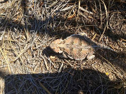
Horny Toad
Atalaya Mountain is a popular hike on the outskirts of Santa Fe.
The mountain is 9,121 feet high (=2,779 meters), and there are several hiking trails. The most popular starts at St. John's college and it is easy to find (just follow the signs for St. John's college from the Old Town).
Atalaya is a Spanish term meaning "watchtower". They used to watch out for fires here.
The trail is mostly shaded and uphill through a forest which changes from pinon-juniper to ponderosa and Douglas fir and some white fir as you climb. At the top you'll have a full view of Santa Fe and the surrounding valley.
Rating: moderate (steep at some sections)
Distance: 7 miles from St. John's College
Highest point: 9,212 feet; lowest point 7,340 feet (St. John's College)
Elevation Gain: 1,800 feet
There are old trails and if you seek an adventure you can hike off the trail higher up. The parking is limited at the trailhead, start early to get a closer parking lot.
![Santa Fe]()
Santa Fe Architecture
![St. John s college]()
St. Jon's College
Santa Fe is the capital of New Mexico. Atalaya Mountain trail is located just outside the town.
Getting There

Santa Fe Architecture

St. Jon's College
To reach the trailhead: from the intersection of Cerrilos Road and St. Francis Drive, go south on St. Francis 0.2 miles and turn onto Cordova road. Continue 1.5 miles , passing Old Pecos Trail where the name of Cordova road changes to Armenta Street. At T intersection, turn left onto Camino Corrales. Cross Old Santa Fe Trail, then bear right onto Garcia Street. At another T-intersection, turn right onto Camino del Monte Sol. Almost immediately, turn left onto Camino de Cruz Blanca, which is signed for St. John's College. Turn right (south) at the entrance to St. John's in 0.6 mile and park in the lot near the entrance at the signs marking the Atalaya Mountain Trailhead.
The description may sound confusing, but Santa Fe is relatively small, and there are signs for St. John's college.
Route Description

Happy Duchess

Well marked trail
After reaching the nose of a spur bridge, the trail swings left and begins to climb. Grades are steep from here to the summit of Atalaya Mountain, which is visible to the right. Where an old, deeply eroded route continues steeply straight ahead, you can turn right onto a more gentle, but still steep, trail. Climb across a steep slope to reach the ridge line at mile 2.5. Turn left and continue 0.4 miles to the summit where a reward of fine views of the city of Santa Fe and the Jemez Mountains awaits. Descend the same way.
Red Tape
There are no fees to hike or park. The hike is well marked with signs, and the trail is easy to follow.Dogs are allowed.