
-
 24021 Hits
-
 91.22% Score
-
 35 Votes
|
|
Mountain/Rock |
|---|---|
|
|
36.12066°N / 74.66127°E |
|
|
Mountaineering |
|
|
Summer |
|
|
23809 ft / 7257 m |
|
|
Overview
Diran is located in the Rakaposhi-Haramosh Range in the western Karakoram. Viewed from the Hunza Valley, Diran is a gentle pyramid and is considered to be the second easiest 7000m peak in the Karakoram after Spantik, although it has a reputation for avalanches. The Karakoram Highway runs up the Hunza Valley and gives easy access to the mountain.
The first attempt on Diran was from Hunza, up the north face and west ridge. Two climbers disappeared high on the mountain. Two more expeditions failed before the mountain was first climbed by Austrians Rainer Goschl, Rudolf Pischinger and Hanns Schell in 1968 by the north face route. This route has since been climbed by a number of expeditions, more expeditions have failed and a fair number of climbers have died.
Doug Scott’s team made the first alpine-style ascent of Diran in 1985. Another alpine-style ascent was made in 1989, without using porters to base camp.
Diran got a second route in 1993 when the northeast ridge was climbed and in 1996 the mountain was climbed from the south.
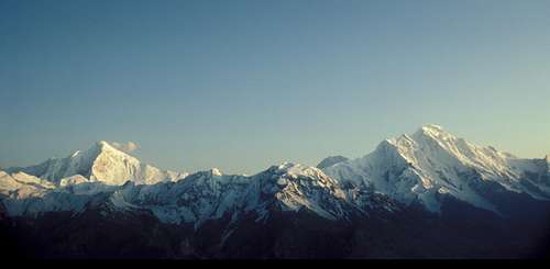
Diran (left) and Rakaposhi
Getting There

Porter and Donkey
The nearest international airport is Islamabad. PIA flies daily from Islamabad to Gilgit, the biggest town in the Northern Areas. The flights are sometimes cancelled at short notice due to bad weather.
Gilgit can also be reached by bus along the Karakoram Highway from Pir Wadhai bus station in Rawalpindi. Buses leave in the afternoon and arrive around mid morning the next day, but can be delayed if the road is washed out or blocked by landslides. See www.lonelyplanet.com/thorntree for a travel forum and the latest on travel on the Karakoram Highway.
From Gilgit get a Hiace van into the Hunza Valley and get off at the Minapin turn off (3 hours drive from Gilgit). Minapin village is the start of the trek to Diran Base Camp. The village is some way up a hill from the turn off. Otherwise get a van to Karimabad (3 hours drive) which is a pleasant place to stay. From here a jeep can be arranged to take you directly to Minapin. Easier still, hire a jeep in Gilgit to go directly to Minapin.
The Karakoram Highway continues north of Karimabad up the Hunza Valley to Passu and over the Kunjerab Pass to Kashgar in the Xingjiang Province of China.
Trekking to Base Camp
Porters can be hired in Minapin or Chirah. Pay will be per stage. On trekking routes there are established stages representing a day's walk, although sometimes more than one stage is walked in a day. Stages tend to be based on the best places to camp. Rates per stage are governed by the Ministry of Tourism, but will vary according to local conditions. If you have a guide he should be useful in negotiations.
North: One day from Minapin village to Tagphari. Day two, cross the Minapin Glacier and walk up to Diran base camp. An advance base camp can be made at 4000m on the glacier below the north face.
South: Two hours from Chirah to a grassy camp site at Biyabari. Day two, follow the eastern side of the Hinarche Glacier to Hinarche Harai, a camp site below the southwest side of the mountain.
Camping

Minapin Glacier
Campsites
There are good camp sites at Tagphari, Diran Base Camp and Hinarche Harai.
Camping Fuel
Kerosene is available in Gilgit and other towns but it burns very sooty so be prepared to clean your stove. White gas is not available. Gas canisters left by previous expeditions are available in Gilgit. Canisters are said to be refilled, but they have always worked for me. Otherwise canisters will need to be freighted from abroad or bought from your agent.
Expedition Food
A good selection of food is available in Islamabad, Gilgit or Karimabad. The only food you might consider bringing with you is special mountain food.
Accomodation
This can be cheap in Pakistan. In Gilgit the New Madina Guesthouse is recommended. Karimabad is a good place to relax before or after climbing. The cheap guesthouses around Zero Point are a good place to stay. I like the Haider Inn. The Diran Guest House is a peaceful place to stay in Minapin. The Bagrot Sarai in Chirah is recommended.
Red Tape
A visa is required and must be obtained prior to arrival. A single entry tourist visa is valid for three months from arrival. It is possible to extend visas in Islamabad.
Now is a very good time to climb in Pakistan in terms of peak fees which have been considerably reduced in recent years. Peaks up to 6500m require no permit (previously 6000m). Peak fees in the Baltoro region have been reduced to 50%. In an effort to encourage people to climb outside the Baltoro region, peak fees in the Gigit region (i.e. Diran) have been reduced to 10%.
The previous fee for peaks between 7001m and 7500m (i.e. Diran) was $2500 for a party of up to seven and $400 for each person above seven.
Now, in 2016, the fee for Diran is a very reasonable $250 for up to seven people, and $40 for each additional person.
Also in the Gilgit region a liaison officer is no longer required. An agent is still required (for expeditions requiring a permit) and the guide they provide can fulfill the role of the liaison officer.
Procedures as organized by your agent will involve a briefing at the Ministry of Tourism in Islamabad before and after the expedition. Not all expedition members are required to attend the briefings, so it is possible to remain in the mountains after the expedition has ended. Usually a returnable helicopter bond must be deposited before the expedition.
For expeditions to peaks below 6500m you can do it all yourself. Just turn up at the last village and start haggling over porters!
Good agents I have used are:
Adventure Tours Pakistan
Himalaya Trek and Tours
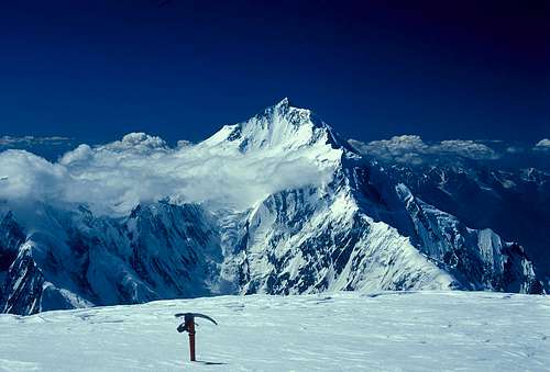
Rakaposhi from Diran
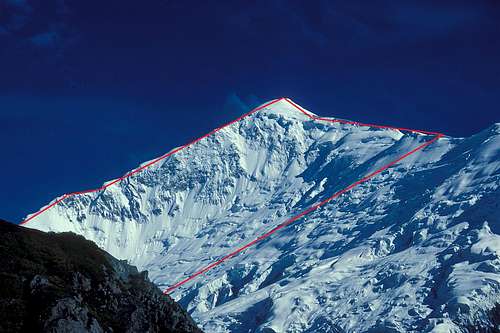
The Route
From the glacier climb the north face, picking a route between crevasses and seracs which will vary from year to year. Deep snow could be encountered and the slope is prone to avalanches. Join the west ridge at 6300m and climb this to the top, which is a large plateau.
When to Climb
The climbing season is from June to mid September. The monsoon from the Bay of Bengal moves westward and reaches Pakistan in late June through to September. The Karakoram is in the Himalayan rain shadow which limits the effect of the monsoon. However when the monsoon breaks down country it’s usually stormy in the mountains. The weather can change very quickly with snow fall higher up or heavy rain at lower altitudes. Climbing in the Karakoram requires considerable patience. There can be extended spells of good weather; the difficulty thing is predicting when they will happen.
The Karakoram summer is hot. Mid summer temperatures in Gilgit at 1494m are around 40 degrees C dropping 6.2 degrees for each 1000 metres. It can be hot even at altitude in the full glare of the sun. At lower altitudes around 5000m there is often not a good freeze and alpine starts are necessary. Avalanches and rockfall are common particularly in gullies and on faces.
Diran Routes
Research
MapsSwiss Foundation for Alpine Research Karakoram 1:250,000 Orographical Sketch Map. Sheet 1 shows Diran.
Popular and useful maps which are generally accurate.
Books
Himalaya Alpine-Style by Andy Fanshawe and Stephen Venables (1996) ISBN: 0898864569 An inspirational book with a section on Diran.
Karakoram: Mountains of Pakistan by Shiro Shirahata (1998) ISBN: 093856725X
Stunning photos including Batura.
High Asia: An Illustrated History of the 7,000m Peaks by Jill Neate (1989) ISBN: 0898862388
Useful reference book.
Websites
www.climbmagazine.com for Mountain Info, a record of world mountaineering.
www.americanalpineclub.org for easily searchable online American Alpine Journal expedition reports.
www.alpine-club.org.uk for the Himalayan Index, a useful starting point to determine what has been climbed on peaks 6000m and above.
http://blankonthemap.free.fr/default.htm is a website in French and English devoted to the mountains of Northern Kashmir i.e. the Karakoram, Nanga Parbat, Hindu Kush and Hindu Raj.