
|
|
Mountain/Rock |
|---|---|
|
|
39.66070°N / 115.626°W |
|
|
White Pine |
|
|
Hiking |
|
|
Spring, Summer, Fall |
|
|
9150 ft / 2789 m |
|
|
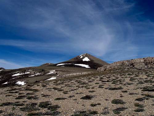
Buck Mountain's summit ahead
Overview
Buck Mountain is another of those Nevada mountains that few people have visited although it is very visible from highway 50. It is easily overlooked however, since it has a much more dominant neighbor, Diamond Peak, just to the west of it but for aprominence peakbagger, it is worthy of a visit.
Buck Mountain is located near Eureka Nevada and is about 20 miles north of Nevada's loneliest highway, highway 50. It is one of Nevada's peaks that has that interesting quality called prominence and comes in at #140 on the Nevada list.
Buck Mountain is really one that I enjoyed and the views from the summit were exceptional in all directions.
Getting There
Most Nevada mountains are off the beaten track and this one was no exception. You have to be willing to drive many miles on dirt roads and be prepared on your mapwork prior to making a visit. Hopefully, the directions and maps I've added here will help you to get to the same trailhead spot we used but ultimately, you are on your own on these roads and you may not see another person for days. We spent four days chasing Nevada peaks over Memorial day and during those four days, we didn't see one other vehicle once we were off the pavement and on the dirt roads.From Eureka, take highway 50 east and after going over Pancake summit, look for a dirt road that heads north (see map). The dirt road is noted on Benchmark's fine book atlas on page 59 as county road one that heads north to Barrel Springs and the Newark Valley. However, there was no sign indicating this so the Benchmark map book is helpful for you to have. I have also included a map of this key junction and would direct you as follows:
Highway 50 to Barrel Springs: 10.5 miles (straight road) On my map, you will find a waypoint included for both the highway 50 junction and Barrel Springs.
At Barrel Springs, the road forks, go right for close to four miles to a signed junction (waypoint 3 on map two) and take the road that leads north from that junction. The road will lead past Beck springs and continue heading north, at one point reaching a narrow section of shelf road that is about 3/4 of a mile long (not a place to meet another vehicle). After this section of road is past, the road improves and another junction (Rock Springs) is reached. Stay to the right and in about a mile, look for a 4WD road that heads west. (waypoint 4 on map 3) Follow this road to its end and you will have arrived at what we used for a trailhead. At this point, you will be twenty miles from highway 50.
A high clearance vehicle is recommended. 4WD was not necessary during our visit but I would not want to be on the Newark Valley road when wet, it would be impassable.
 Looking north Looking north |  Map one Map one |  Map two Map two |
 The sign The sign |  Map three Map three |  North North |
Route
Being able to drive to 7800' was helpful and from where we parked, it was less than two miles to the summit with around 1400' feet of elevation gain. This was a nice and easy hike thanks to the conditions but we did encounter our first mosquitoes of the season near where we parked and some ticks in the sagebrush. The wind came up after we had been on the summit for a good half hour and we took that as an omen to head back down.
 Our trailhead Our trailhead
|  Typical terrain heading up Typical terrain heading up
|  Buck Mountain dead ahead Buck Mountain dead ahead
|
Red Tape
None that I am aware of. This area seems to be mainly BLM land and no negative signage was encountered. We did see a lot of sign of wild horses andmore than likely, range cattle might be encountered on the roads you will be traveling.
Camping
There are no campgrounds in this area but we saw several places where you could camp, using the leave no trace ethics. Eureka has a couple places to stay at (motels). A campground for RV's is on the south end of town. Also a good grocery is located in the middle of town and a good place to have breakfast/lunch at on the south end of town. Its a deli just off the main road.Weather

The summit
There are two highpoints that are within 20 feet of height on this one and our feeling was that the southern one, the one with the benchmarks and register was the higher of the two. However, for some, it might be prudent to bag both of them if you aren't sure that the southern summit is higher. Ken Jones used a surveyors instrument to check out the northern summit (Pk 9141) and one other peakbagger, John Vitz went to both summits and felt the southern one was the higher of the two. Regardless, the views are excellent and look well to the north, east and south while the western views are pretty much blocked by the bulk of Diamond Peak.Not many people have visited this summit over the years and a register was placed in 2003 by Gordon MacLeod and Barbara Lilley.
The next visitor was John Vitz in 2006 followed by some geology students and then Ken and I in 2010. Since Ken and I have been there, at least another 8 have visited this one. Most can be found on peakbagger.com but not all. I have included pictures of the register pages that were present at the time of our visit.

Register placed in 2003
 |  |  |
Summit views
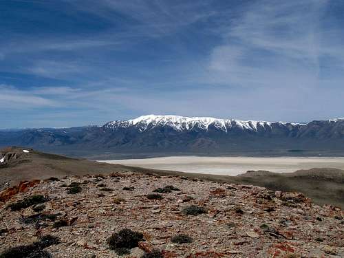
Diamond Peak to the west from the summit
On a clear day in Nevada, views from just about any summit can be amazing but on the blue bird day we had, we really did have wonderful views in all directions. One of the nice things about a prominence peak is that you are generally center stage and here are a few pics to illustrate what I mean.
More - from north, east and south
 |  |  |
Nearby bonus
If you are interested in prominence peaks, then have I got a deal for you. You can easily add a second peak on the same day if you are willing to check out Prospect Peak near Eureka. Prospect Peak can be a drive up (we hit snow and had to hike to the top which is OK). You will find more info on this one underthe trip report section at the left of this page. (See Prospect Peak, 2nd one of the day)