Page Type Page Type: Mountain/Rock
Location Lat/Lon: 38.14630°N / 122.59159°W
Additional Information County: Marin
Activities Activities: Hiking
Seasons Season: Spring, Summer, Fall, Winter
Additional Information Elevation: 1558 ft / 475 m
Sign the Climber's Log

Overview

 
Burdell Mtn. summit view northeast
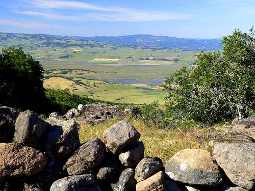
View northeast from the old summit wall
Burdell Mountain is the principle feature of the Mount Burdell (go figure) Open Space Preserve. This is a big hill just north of the town of Novato in northern Marin County. The mountain provides a recreational playground for hiking and mountain biking. It also includes Olompali Historic State Park on it's northeast side.
This was once the home of the Coast Miwok Indians. The park is the site of the oldest house north of San Franscisco built by Chief of the Olompali Tribe Camillo Ynitia in 1776.
There is an abandoned rock quarry near the southeast summit. The south side has big open grassy slopes and the summit is the high point on a ridge line interspersed with oaks that is defined by an old primitive rock wall a few feet high.

Getting There

 
Burdell Mtn. view south
South from Burdell Mtn. over Big Rock Ridge to Mt. Tamalpais
From the north: From Olompali State Park. The park is located 3 miles north of Novato on Hwy. 101. It is only accessible from the south. If you're northbound go a ways until you can make a U- turn to go south and enter the park. A trail goes south and then climbs 1.5 miles up the northeast side of the mountain through forested terrain to a fork a few hundred feet from the top. You can continue straight on up to the road along the top of the mountain and go around to the right by the rock quarry or go right at the fork which is a short cut leading to the same road. Continue northwest on the road a few 10ths mile and cut up to the right through an open slope interspersed with rocks to the high point with the rock wall that runs along the top. The actual summit point is anybodys guess!

From the south: From the last Novato exit going north (Atherton) go west on San Marin Drive. A fire road running along the base of Burdell Mtn. that leads to several trails can be accessed from a few cul de sacs:

San Carlos Way: From 101 take San Marin Dr. 1.6 miles, turn right on San Carlos Way and go 2 1/2 blocks to the trailhead.
San Mateo Way: From Hwy. 101 take San Marin Dr. 2.1 miles, turn right on San Mateo Way and go 1 block to the trailhead.

For more entance locations and detailed descriptions of the trails on and around the mountain visit Bay Area Hiker, Mount Burdell Open Space Preserve.

Red Tape

 
Pond on Burdell Mtn.
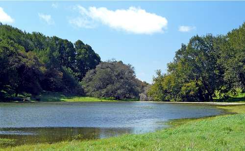
Hidden Pond on Burdell Mtn. south side
There are no entrance or parking fees. Hikers and cyclist share most trails.

Dogs on leash on trails. They are allowed off leash on fire roads if they heed commands. Dog are not allowed in the parks sensitive wildlife area.

Camping

Burdell Mtn. summit northwest view
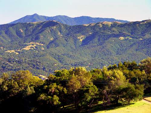
Northwest from summit
There is no camping in Mount Burdell Open Space Preserve.

Current weather and 5 day forecast

For the current Novato weather and 5 day forecast click here.

Children

Children

Children refers to the set of objects that logically fall under a given object. For example, the Aconcagua mountain page is a child of the 'Aconcagua Group' and the 'Seven Summits.' The Aconcagua mountain itself has many routes, photos, and trip reports as children.