-
 18374 Hits
-
 79.78% Score
-
 11 Votes
|
|
Mountain/Rock |
|---|---|
|
|
45.07322°N / 109.54842°W |
|
|
Hiking, Scrambling |
|
|
Summer |
|
|
11441 ft / 3487 m |
|
|
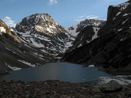
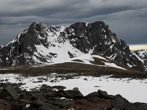
Spirit Mountain and Thunder Mountain from Black Canyon Lake
Overview
The majority of mountaineering activity in the Beartooths focuses on the big 12,000' peaks, including Granite Peak, which is at once the range highpoint, Montana's highpoint, and one of the five most difficult state highpoints to climb (it is third or fourth, trailing Denali and Rainier and vying with Gannett and Hood for #3).
But there are other mountains in the Beartooths, and as is often the case, the ones that don't make the popular lists can be the gems that seekers of wilderness and solitude hope to find.
Thunder Mountain is such a peak. Although it is not technically difficult to climb-- the hardest part is a boulder field along the approach to the peak-- mountains do not come in better settings than this one does. Below it is beautiful Black Canyon Lake. And from it are views of some of the Beartooths' (and Montana's) biggest, highest mountains-- Rearguard, Beartooth, Sky Pilot, Whitetail-- and two glaciers, Beartooth and Grasshopper (the latter is one of two in the range named for the millions of frozen grasshoppers, some thousands of years old and/or extinct, found in the ice, though recent melting has been "freeing" the grasshoppers' bodies, decomposing them and diminishing their numbers).
Something you won't find here is a lot of people. The difficult approach to Black Canyon Lake deters all but a relative few, and most who do visit the lake seem to be anglers and hikers. And since the peak is fairly obscure and not one of the aesthetic wonders of the range, still fewer seem to bother going up from the lake. In fact, most mountaineers who reach the lake are actually headed to Beartooth Mountain.
Weather-- if Thunder Mountain should live up to its name, and Beartooth weather is infamously capricious, it is a bad place to be. The summit plateau is long and relatively flat, and there is no shelter. Watch the weather closely as you ascend.
Getting There
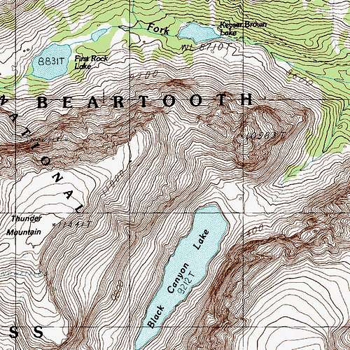
About 9.5 miles southwest of Red Lodge along the Beartooth Highway (U.S. 212), turn onto signed FR 2346 (Lake Fork Road) and follow this good road almost two miles to a large parking area where there are pit toilets and a board with maps and regulations for the Absaroka-Beartooth Wilderness.
Route
There are three legs to this climb: the trail hike, the "hike" to Black Canyon Lake, and then the mountain itself.
This route is about 17 miles RT, with about 4300' of elevation gain. Most people will probably prefer to camp somewhere along the approach or make a base camp somewhere along the trail so that Thunder Mountain and Black Canyon Lake can be two of several destinations on a multi-day trip.
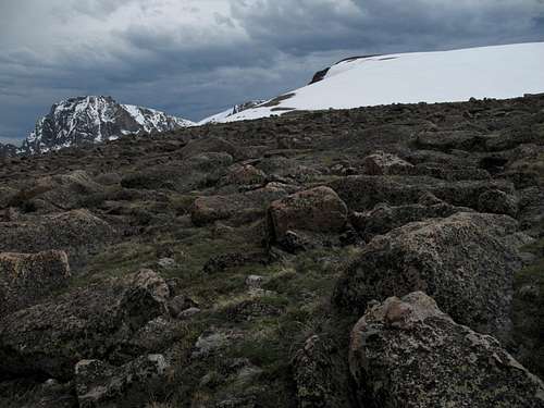
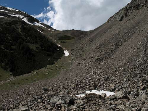
Tundra and the summit
Trail
Enjoy this part, for it is easy. Hike on Lake Fork Trail for 5 miles until you reach a bridge across the stream. This is about half a mile past the signed turnoff for Lost Lake. Elevation gain over these 5 miles is only about 1000'. Much of the time, trees block views of the high country, but the rushing stream and occasional openings will whet your appetite.
To Black Canyon Lake
Do not cross the bridge. Just before the bridge, look to the left and find several use trails. There is no sign, but these trails take off in the direction of Black Canyon Lake. The widest, most heavily worn trail is the best one to take.
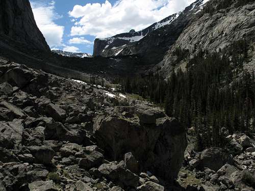
Good luck staying on the trail. I have hiked to or from Black Canyon Lake four times now, and only once did I manage to stay on the trail most of the way. The trail climbs steeply through the forest, is often faint, and frequently disappears. But don't worry too much; bushwhack to follow the path of least resistance, keeping a drainage to your right, until you break out of the trees at the base of the boulder field mentioned in the Overview section.
Boulder field
When you reach the boulders, drift right along the base and look for a cairned use trail. This trail does not entirely avoid the boulders, but it cuts a lot of the rock hopping, and the worn path makes the going easier. This trail leads all the way to a rise right above Black Canyon Lake and then leads down to it. If Thunder Mountain is your goal, you do not want to go down to the lake but rather want to stay high and begin the next leg of the climb.
If you do not find the trail, just expect a lot of Class 2+ and 3 conditions. For the most part, the boulders are pretty stable, but the field has its share of loose ones.
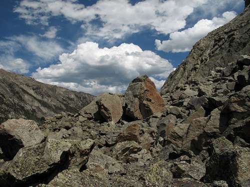
Boulder field
From Lake Fork Trail to Black Canyon Lake, it is about 2 miles with about 1200' of elevation gain (the lake is at 9200', but the rise above it is closer to 9400'). The part through the trees is steeper, but it is also shorter.
It's my understanding from locals that Black Canyon Lake has excellent fishing, but I don't fish and therefore don't really know.
The trip to the lake is not much fun, but the scenery and solitude are worth it. Because the approach is so tedious, the lake receives only a small fraction of the visitation it would if there were a maintained trail to it.
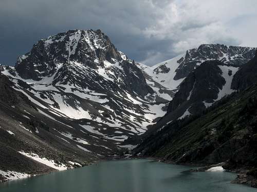
Black Canyon Lake-- click for caption
To the Summit
From the rise, notice the obvious saddle to the north-northwest. That saddle is your next destination, and you'll climb almost 1000' in a little over half a mile to reach it. Yes, it's steep, but the footing isn't too bad for Class 2 terrain. The saddle is at about 10,300', but you can cheat left a bit as I did in order to shave a little distance and gain Thunder Mountain's eastern flanks a little higher.
Saddle
The eastern/northeastern flanks are too broad to be a true ridge, in my opinion, but in any event, follow these slopes across tundra and rocks to the summit. It's very steep at first, but the grade abates around 10,800' after a quarter-mile or so. The rest is a pretty easy walk to the summit. I did encounter a sizable snow slope, but it was gentle going, not even steep enough for a glissade on the descent.
Easy, scenic walking the rest of the way
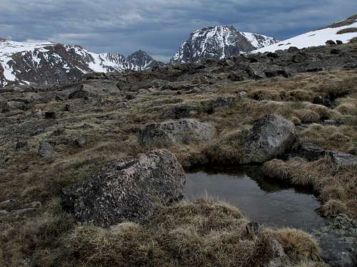
Up at the summit, there are two rock outcrops a little distance apart; I am not sure which is the higher, and as a storm was moving in, I did not stick around long to play the GPS game and find out. So if it's that important to you, get atop both. If I had to guess, I'd say the outcrop to the north is the higher one because there is an enclosure there obviously constructed by other people. However, there was no obvious summit cairn or register, and I believe it would be better to leave the mountain that way.
The money view...click for details. There are several more summit views in the image gallery. I decided not to display them on the page in case some readers want the information but prefer to save the views for seeing them in person.
From the rise above Black Canyon Lake to the summit, the distance is about 1.6 miles with an elevation gain of about 2100'. You have to really try hard to make this any harder than Class 2.
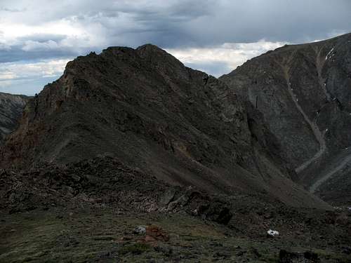
Peak 10,583T

"Welcome to Montana."
As I stand on the sturdy wooden bridge spanning Lake Fork and gaze at the craggy mountain rising directly over the clear, rushing trout stream, that is what I think. It could be the title, and the scene could be the picture, of a Montana travel brochure. (See the primary image.)
The setting is like something out of A River Runs Through It, the story or the movie-- you take your pick; I love both.
No great monarch of the West this mountain is, though; it is instead the unheralded Peak 10,583T, or, as I like to think of it, "Little Thunder Mountain." Wedded to Thunder Mountain by a ridge and rising slightly more than 300' from the saddle between them, the peak has the prominence and, I would argue, the character, to deserve its own official name, but for some reason it doesn't have one and is technically a lesser summit of Thunder Mountain.
It doesn't really matter; prominence, rank, and the like are really just arbitrary human ways of corralling the mountains into our terms and ought to mean little to you unless you are into lists. Plus, "Little Thunder Mountain" is anything but "little"; although it is almost 1000' lower than Thunder Mountain, it is a harder climb than its neighbor is. Thunder Mountain is just a Class 2 walk-up; Little Thunder Mountain, after the approach, is a sustained scramble with Class 3/4 terrain and exposure. The views are better from Thunder Mountain, but the climb up Little Thunder is better, and the views are still very nice; I recommend climbing both since they are so close to each other.
In the image gallery there are some views from the peak, but the pictures displayed on this page focus on route details.
Route
There are three legs to this climb: the trail hike, the "hike" to Black Canyon Lake, and then the mountain itself. The first two are already covered above, so let's go to the climbing part.
(This route alone will be about 16 miles RT, with about 3400' of elevation gain.)
From the rise above Black Canyon Lake, notice the obvious saddle to the north-northwest. That's not where you're going, even though maps and intuition will say it is.
The saddle-- don't go here.
Now look right from the saddle and notice a notch. That, too, is not your destination. There, you will find sheer cliffs impeding progress.
The notch-- don't go here, either.
Now, this is not to say that you can't climb the peak from the saddle or from the notch. However, my observations from the approach, the climb, the summit, and the climb of Thunder Mountain all suggest that a route along the west ridge will involve at least two deep notches with cliffs that likely are "unclimbable." It may be possible to bypass the notches, but that will almost certainly involve traversing loose terrain and losing elevation.
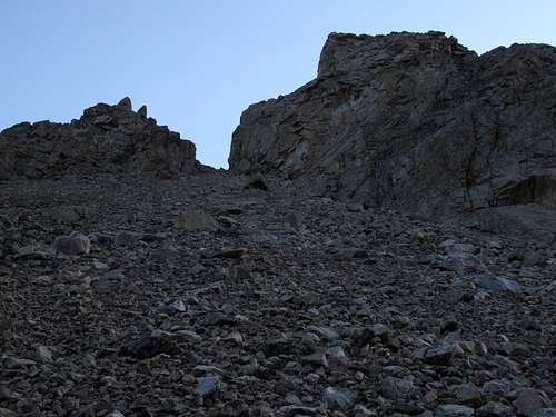
So instead, start hiking toward the notch but notice a pillar (right of and below it) that soon comes into view and stands out more and more as you get higher.
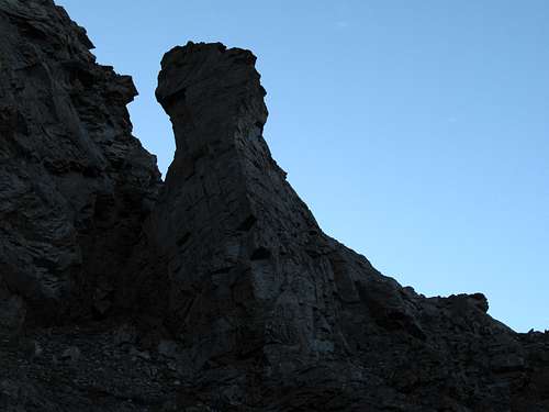
The pillar-- yes, go here.
Make for the base of this pillar and then notice and follow some ramps to the right of it. Negotiating these ramps involves some Class 2+/3 maneuvering and some exposure, but it is nothing for an experienced scrambler to worry about.
As you get off the ramps, you enter a broader area in which more options appear. Two main ones exist-- the first stays close to the pillar as it climbs above it, and the second moves off to the right amid some grassy slopes, ribs, and small buttresses. The advantage of the first option is that it climbs more directly to the summit; the disadvantage (arguably) is that there is some Class 4 terrain. The advantage of the second option is that it is easier-- lots of sustained scrambling, but nothing harder than Class 3-- but the disadvantage is that it is less direct.
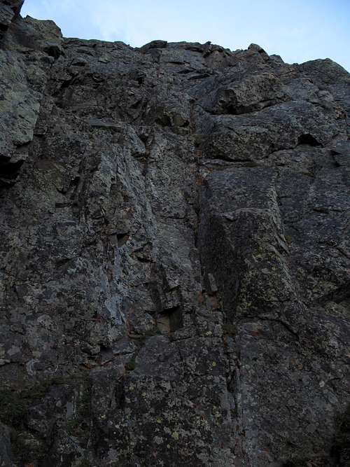
Class 4 Section
Either way leads to the summit, though; there are no route-finding mysteries involved.
Mistakenly believing that the second option was the more direct one, I used it on the ascent. Descending, I decided to explore the first option, and I went both up and down the Class 4 section to get a good feel for it.
From the rise above Black Canyon Lake, the climb to the summit covers only about a mile and 1100-1200' of elevation gain. Once you leave the talus slopes that approach the peak, expect a good amount of (fun) scrambling.
Climbing the Pillar?
If you are interested in climbing the pillar, I can tell you that I got to within arm's reach of a narrow ledge just below the summit through some awkward and exposed Class 4 and low 5 climbing. The move to reach the ledge was, I estimated, in the 5.3-5.4 range, but I felt the exposure created too much risk on an unroped climb of such a minor objective, and just below that ledge was as far as I went. But a more daring free soloist or a trad climber skilled in placing protection (it's a very short pitch, so little gear would be needed) should have no trouble with it. In my pre-fatherhood days, I probably would have gotten up there myself, but now I'm a little more conservative about such situations.
Camping
There is not a campground at the trailhead.
If you are going to backpack in, there are really three camping options:
1. Camp along Lake Fork where the route to Black Canyon Lake leaves the main trail. This is where the sites are best and most numerous, but it leaves all the tough stuff for summit day.
2. There are some suitable sites at the base of the boulder field, especially near the use trail through it. The only problem is that most are in sandy depressions, which makes them comfy but prone to flooding if there is a storm, and storms in the Beartooths are common.
3. Up at the rise above Black Canyon Lake, I found what seemed to be the only decent campsite. It was a small, pretty flat, and not terribly rocky area that had enough room for a two-person tent. But other than that site, pickings were incredibly sparse up there; all around the lake, the land is steep and rocky.
Red Tape
Nothing special as in fees or permits. Read the posted regulations at the trailhead.
This is bear country, and proper food storage is required. Grizzlies are not that common in this area of the Beartooths, but pepper spray is still not a bad thing to have anywhere in Yellowstone country.
Topo Map