
-
 14773 Hits
-
 88.19% Score
-
 26 Votes
|
|
Mountain/Rock |
|---|---|
|
|
45.13062°N / 109.88744°W |
|
|
Hiking, Mountaineering, Skiing |
|
|
Summer, Winter |
|
|
11552 ft / 3521 m |
|
|
Overview and Route Information

Do not confuse this with the Iceberg Peak in Glacier National Park, also in Montana.
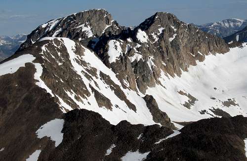
Making up part of the cirque that holds the Grasshopper Glacier, Iceberg Peak, though not a visually spectacular mountain itself, resides among some of the best scenery and most impressive peaks in the Beartooth Mountains. The view from the summit is one of an "ocean of peaks"; in every direction there are high mountains. The rugged, seldom-climbed peaks of northeastern Yellowstone National Park are visible, as is Pilot Peak, a mountain in the Northern Absarokas that is arguably the most striking peak in Greater Yellowstone.
I am assuming the mountain gets its name either from small icebergs in the lake below Grasshopper Glacier after being calved by the glacier or from the floating bergs resulting from the summer breakup of winter's ice. When I was out here, the lake was still completely frozen over, so I cannot say which it is based on personal observation.
With the right vehicle and essentially snow-free conditions, climbing this peak involves no more than a moderate, fairly short trail hike and a shorter hike up a ridge. When deep snow still covers the area, though, as it did when I climbed the peak on July 2, 2010, it can be much more of an adventure (and more fun). If you don't care for snow travel or have no experience with it, play it safe and wait until August for this one.
This area of the Beartooths is also popular in winter with skiers because of snowmobile access to the forest roads. However, I am not the right person to write about avalanche danger, the best lines, etc.
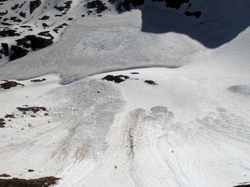
Clinging to the northeastern side of Iceberg Peak and the northwestern side of Mount Wilse, Grasshopper Glacier is a highlight as well. There are several glaciers, small and getting smaller, in the Beartooths, but Grasshopper Glacier is one of three (the other two are Hopper Glacier and another Grasshopper Glacier) that stand out due to a special feature: millions of grasshoppers encased in the ice. Some of the grasshoppers (technically locusts) are hundreds of years old, and some of the species have been extinct for over 200 years. No one is certain of how the grasshoppers wound up trapped there, but scientists who have studied the glacier believe the insects were caught in a storm while migrating over the mountains, and then years of accumulating ice and snow encased and preserved them. As the glacier has receded, the grasshoppers have come into view and people sometimes dig out ice-bound specimens. Now, though, the glacier is receding so much that bodies are being exposed and thus subjected to decomposition. No one knows how many grasshoppers are left or how long it will take for all of them to be "freed" and then decompose, but if you want to see the grasshoppers yourself, it is advisable to go sooner rather than later with the way the glaciers of the Northern Rockies are melting out these days (this glacier, once over five miles long, is now no more than a mile long and half a mile wide). There is a trail to a saddle overlooking the glacier, and from there you can head down according to your interest and ability. Don't venture far onto the glacier unless you know what you are doing; late summer will feature a surface that is more ice than snow, and there are crevasses on the glacier, small but still enough to injure or kill you if you fall into one.
Here is some more information about the glacier.
Grasshopper Glacier
Route Information
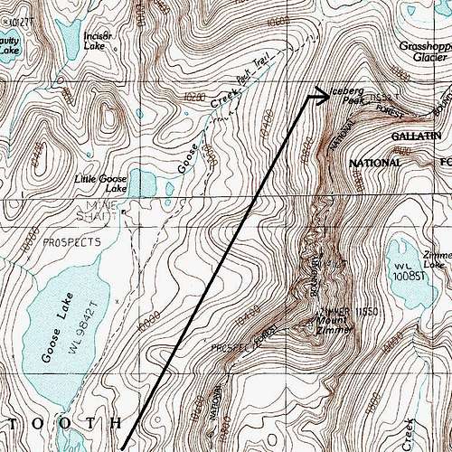
The Basics: Approximately 5 miles to the peak and about 1800' of elevation gain; first four miles Class 1 on a trail, last mile Class 2.
Trail and my route
From the end of the road to Goose Lake (see Getting There), there is a trail leading to an overlook of Grasshopper Glacier at the saddle between Sawtooth Mountain and Iceberg Peak (the glacier is not visible from the saddle; you have to hike east a little to see it, and you can of course see it from Iceberg's north ridge and the summit area, though not from the highpoint itself). The Forest Service indicates this hike is four miles. Because the trail was buried under deep, rotten snow when I was there, I used an alternate route and cannot verify or contradict that measurement, but it should be fairly accurate since a measure on a map suggests three miles and there are some switchbacks even though the rest of the trail is pretty straight.
In any event, the trail starts at about 9800' and climbs to about 10,650' at the saddle. You hike through a beautiful alpine basin with great views of lakes and peaks. There are, though, three stream crossings that might pose trouble. Near the beginning, the trail crosses the outlet stream from Goose Lake (because of the snow cover, I could not tell if there was a bridge). It crosses the outlet again at the south end of the lake, and again I cannot say if there is a bridge. There is a third stream crossing later on at about 10,200', and once again I am unable to say if there is a bridge there, but I doubt there would be at that point. If there are no bridges and the water levels are high or you just do not like fords, it should be easy to avoid the first two crossings by staying on the right (east) side of the stream, but please be careful not to wear a use trail into the tundra and be aware that to avoid the first crossing, you will have to go out of your way to pass a small lake to the south of Goose Lake. The third crossing should be easy to avoid by continuing ahead and rejoining the trail when the stream is low enough or gone entirely.
From the saddle, hike up the north ridge (Class 2) to the summit. It is only about a mile, with a climb of about 900'.
I can't remember if it was at this summit or on Sawtooth Mountain, but I found a dilapidated register that looked so ready to fall apart that I didn't even touch it. Now, I am no fan of summit registers, especially of placing them on peaks that don't have them, but if you are into registers, you might consider carrying a new one up to replace the decrepit one.
 Summit
 |  Summit view
 |  View
View |
If the trail is buried...
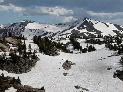
The Beartooths typically get a lot of snow, and it is entirely possible, perhaps even likely, that the trail and basin will be covered in deep snow in early summer as it was in 2010 when I climbed there.
If that is the case, you can always still try to follow the course of the trail; it would not be hard as a matter of navigation. However, when I was there, I found the snow deep and soft, especially in low-lying areas such as those the trail goes through. Since the going was so tedious, even in early morning before the sun had hit the snow, I wanted no part of dealing with that trail and the potential hazards of the hidden stream crossings.
Instead, I found a pretty good route by gaining the ridge just east of the trail's beginning and traversing from there in the direction of the saddle. Doing this, I managed to stay high as well by contouring around the heads of some smaller basins rather than dropping into them. This also made for a more direct approach to the peak, and I did not go to the saddle. When I was high enough, almost on eye level with the saddle, I went directly up talus slopes to the summit. This was mostly Class 2 with a little easy scrambling that probably wasn't necessary but struck me as the path of least resistance.
 Winter wonderland in July...
 | 
| 
|
Until I headed directly up the slopes to the summit, almost all of the route was on snow. Most of the time, it was soft enough, and the grades gentle enough, to leave my axe strapped to my pack, but I did use the axe when contouring across the steep slopes at the heads of the smaller basins I avoided dropping into. The closer I got to open areas, the more postholing I did.
My GPS device went crazy that day and left me without a track for the route, but I estimate it at four to five miles.
Descending, I did use the north ridge, so it is not speculation that the ridge is a Class 2 hike.
Sawtooth Mountain, Wolf Mountain, and Sawtooth Peak #3
Getting There
When the trail is clear of snow, the hardest part of this climb is probably the drive in.Two or three miles east of Cooke City, between the Soda Butte and Colter campgrounds, turn north onto an unpaved road signed for Lulu Pass. Drive approximately two miles to a signed junction with the Goose Lake Jeep Trail and turn onto it. In Select Peaks of Greater Yellowstone, author Thomas Turiano mentions a high-clearance creek crossing just before this junction, but for some reason I don't recall any crossing there at all. The stream may have been dry, or there might have been a bridge I didn't pay attention to; maps do show the crossing.
The rest of the way, however, you will need not only high clearance but also four-wheel drive. The road immediately becomes extremely rocky, with many spots that are so narrow and with such large rocks that you will want to have a spotter. If you think you or your vehicle is not up to this road, there is plenty of room to park around the junction.
I wish I could give details about the whole road, but one mile in, a deep, soft snowbank blocked the road, and I decided not to chance it and to hike the rest of the way in. The road is very popular with ATV users, and a large group came by, but they could only make it about half a mile past where I stopped. This was on July 1, 2010, and the snow was blocking the road at about 9300'. And after I had hiked about a mile, I rarely saw much of the road the rest of the way.
What I can say:
1. The Forest Service says the road is four miles, but it is closer to six; I hiked 4.5 miles from my parking spot to a ridge just east of the road's end.
2. There were stream crossing at the outlets of Round Lake, Long Lake (marked as Lone Lake on the USGS quad, but that is a mix-up with a smaller lake in the vicinity that is the actual Lone Lake), and Star Lake. These stream crossings were not trouble for me on foot, knee-deep at worst, but conditions can always vary widely. In many places, the road had become a de facto streambed for the melting snow.
3. It was hard to tell because of the snow cover if a stock SUV or pickup could make it all the way, but there were sections that told me it would not be easy. That said, I would be far from shocked to learn that stock vehicles have made it all the way, especially in the hands of skilled, determined drivers.
4. The scenery is beautiful, especially by the three major lakes. The conditions were a mixed blessing; I didn't like the extra hiking and found it exhausting because the snow was both deep and soft, but I was the only one out there. Turiano describes the area around the road as a veritable wasteland marked by "roads, tracks, erosion, stumps, and trash," and I saw some signs of that, but the heavy snow cover made the place look almost pristine. An area that is an ATV playground was blessedly silent, and out beyond the wilderness boundary, there were no signs that anyone else had been there recently.
Sheep Mountain, the best sight and a major landmark along the access road
Red Tape
There are no fees or permits involved.The alpine area around Goose Lake and the peaks is not prime grizzly territory, but all of Greater Yellowstone is bear country and most of it is grizzly country, so take the precautions that grizzly country dictates. Plus, the terrain around the access roads is prime grizzly habitat, and a fatal attack occurred at Soda Butte Campground in July 2010.