
|
|
Mountain/Rock |
|---|---|
|
|
36.59682°N / 118.44465°W |
|
|
Tulare |
|
|
Hiking |
|
|
Spring, Summer, Fall, Winter |
|
|
12766 ft / 3891 m |
|
|
Overview
Kern Point towers over upper section of the Kern River canyon although it is at the relative low end of a ridge that starts at Milestone Mountain, become Milestone Mesa, and eventually turns into the Kern Ridge. Kern Point is one of the 248 list peaks designated by the Sierra Peaks Section of the Sierra Club Angeles Chapter. One of the more remote peaks in the High Sierra, the mountain is relatively easy to climb, albeit after a long approach from any direction. But the views over the canyon to the Sierra Crest are well worth it. The peak is difficult to spot from peaks along the Sierra crest as it blends into the higher profile Great Western Divide mountains.Kern Point is named after the river that it rises over. According to Place Names of the High Sierra (1926) by Francis P. Farquhar, explorer-soldier John C. Fremont named the river “for Edward M. Kern, topographer and artist of Fremont’s third expedition.” A Climber’s Guide to the High Sierra (1954), edited by Hervey H. Voge, credits the first ascent to William Horsfall and C. Laughlin in 1924.
 Kern Point as viewed from Milestone Mountain (Jul 10)
Getting There
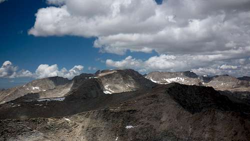
Due to its remote location, Kern Point can be approached from a number of different directions depending on the itinerary. The closest trail head approach is via the Shepherd Pass trail but easiest route is available to those hiking the Colby Pass Trail or the High Sierra Trail. Entry into this region is also available from the west, though a lot longer. Kern Point has been day hiked (20+ hours) from Shepherd Pass Trailhead. Kern Point from the north (Sep 10)
Routes
There are a number of easy (but tedious) scrambling routes up Kern Point and probably some other undocumented routes that are possible.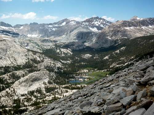 |
The easiest route to the summit is from the vicinity of Gallats Lake at roughly the 10,000 feet elevation mark on the (east side of the) Colby Pass Trail, using an easterly traversing scramble through vegetation, scree, and talus. But any part of the southern face is climbable. Class 2. |
| Gallats Lake during the traverse to the summit (Jul 10) | |
 |
Kern Ridge proper can be easily gained from Colby Pass and then followed all of the way to the summit. This is a long and circuitous route involving several miles of ridge traversing. Class 2. |
| The long Kern ridge back to Milestone Mesa (Jul 10) | |
 |
The north and east faces have ample routes that climb steep slopes directly to the summit. There may be cliffs in areas that need to be negotiated. Class 2&3 |
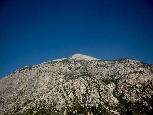
| East face in the vicinity of Junction Meadow(Jul 10) |
Red Tape , Camping, and Conditions
Everything you need to know about permits, regulations, and driving directions can be found on the Eastern Sierra - Logistical Center page. While overnight hikes require a wilderness permit, day hikes can be done without red tape with the exception of entry from the Whitney Portal.Climbing can be done in almost any season but May through October are the most popular times. In heavy snow years, the chutes and slopes may hold residual snow. This is also true for any of the routes over the Sierra Crest. Check for current weather.
 On the traverse back to Gallats Lake
External Links
Trip Reports:Climber.org reports
Bob Burd's trip report
Pictures:
My pics & summary
Langenbacher - Sep 18, 2012 4:56 pm - Hasn't voted
Location LocationVery interesting page, but I think you have the wrong location for the summit. Try 36.596822 -118.444646
bechtt - Sep 18, 2012 11:56 pm - Hasn't voted
Re: Location LocationHey, how did that happen? Thanks for catching it, Harry. Tom