
-
 20954 Hits
-
 84.27% Score
-
 18 Votes
|
|
Mountain/Rock |
|---|---|
|
|
47.56022°N / 121.60848°W |
|
|
Download GPX » View Route on Map |
|
|
King |
|
|
5166 ft / 1575 m |
|
|
Overview
Just getting near the Bessemer summit (the northern-most high point) constitutes most of the challenge in climbing this prominent Middle Fork peak. The CAG (through the 3rd edition) recommends approaches from the North Fork via Hancock Lake (now on gated roads), or up Quartz Creek road to Blethen Lakes (now overgrown). Most recent ascents are via the SE ridge or traversing from South Bessemer after a 5-mile walk up the Bessemer road. The south peak of Bessemer only has ~250 feet of prominence, but is more accessible via logging roads that wind all the way to the top. Good access, terrain with moderate avalanche potential and great views make South Bessemer a popular winter ski or snowshoe destination. See the separate page for South Bessemer.  Bessemer from Middle Mtn Bessemer from Middle Mtn | 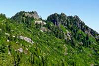 Bessemer from spur road at 4600' Bessemer from spur road at 4600' | 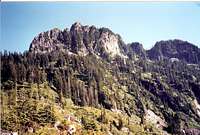 Bessemer from Upper Blethen Lake Bessemer from Upper Blethen Lake | 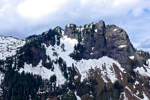 Bessemer from Bessequartz ridge Bessemer from Bessequartz ridge | 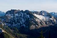 Bessemer from Hancocks Comb Bessemer from Hancocks Comb |
Getting There
From Interstate 90 take Exit 34, turn north under the freeway and in .45 miles turn right on the Middle Fork Road. You'll cross the Middle Fork River on a large concrete bridge at 5 miles. The Bessemer road is at 7.1 miles. There is a pull off on the north (left) side with room for several vehicles, but do not block the gate. There is a additional small paved pullout just ahead on the right and beyond the curve a larger paved pullout. The Bessemer road is on state DNR land and is open to non-motorized access.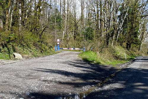
Bessemer road and gate
The SE ridge route starts from the intersection of the CCC trail with the Middle Fork road at 9.5 miles. There is a chip-sealed pullout with room for about 10 cars here.
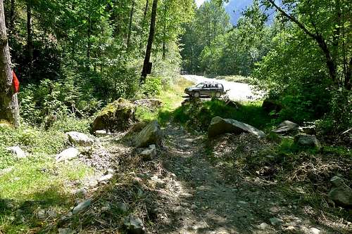
Intersection of CCC trail with the Middle Fork road at 9.5 miles.
The Bessemer Road
A bike is highly recommended for the first 1.5 miles across the valley floor to the Wisdom Earthworks site. The road surface is good and the grade is not steep. The bike makes for a fun and fast trip out. In 2011, the road surface up to the intersection at 3200' that leads to the ridge was in excellent shape for mountain bikes. In 2012 the daylighting logging operation churned up the surface, but it's still bike-able. The grade is steep enough that most people will need to push a bike most of the way up, but coming down is a blast as long as you have good brakes.Karen Sykes wrote about hiking the Bessemer road at Hike Of The Week: Scenery and conditioning all in one
Wisdom Earthworks has an easement on the Bessemer road for talus mining on private land high on the mountain and their 25 year lease still has many years left on it. In 2012 the Bessemer road was "daylighted" meaning that 20' of timber on either side of the road was cleared. It opened up some views, but made the road trip even bleaker than it was before. Watch out for and stay clear of any heavy trucks hauling out on this road.
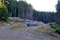 Wisdom Earthworks Wisdom Earthworks | 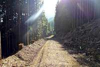 Bessemer Daylighting Bessemer Daylighting |
Red Tape
A Discover Pass is required to park at the Bessemer road gate because this section of the Middle Fork road is on DNR land.Trip Reports
09/24/2011 - Martin Shetter & Monty VanderBilt via Bessemer road2008 - Mike Collins via SE ridge
This report is posted here with permission from the author
You have to admire a mountain which does not give up its secrets easily. This was my fifth outing to reach the top of this peak which lies at the western edge of the Alpine Lakes area. Three of the trips were in the winter so falling short of the summit is more excusable. Having now summited I can definitely advise against a winter climb. It is best in the late summer or early fall. Exactly 7 miles past the ending of the asphalt surface on the Middle Fork of the Snoqualmie road a spur road will appear on the left. It is the end of the historic CCC road built in the early 30's. At 960' elevation here it is the beginning of the shortest and least brushy route up this peak. As soon as you close the car door look up at the rocky ridge in front of you. It is this ridge which will take you most of the way up to the summit. One reconnects with this ridge at 1,600' by walking up the CCC road for about 1/2 mile and then following a logging road to the right. It is easy to follow as it is the only rocky road among the several encountered. It eventually becomes narrow and trail like. At 1,600' it reaches a flattened area and it is here where one leaves to gain the ridge off on the left. Stay on the ridge until bumping into a cliff wall at about 3,200'. Here one must descend slightly to the left and traverse to a gully filled with brush and grass on the right about 200' away. Ascend this gully until regaining the ridge at about 3,400'. Stay on the ridge now until 4,500'. The few exceptions where one must deviate off this ridge are brief and always to the left. At 4,500' one must down climb to the right about 80' and traverse several hundred feet to a wide gully on the left. It is the only gully which angles itself to the north. Ascend this gully until reaching the ridge of Bessemer itself. At the ridge there one must go to the right and stay on the ridge itself pushing the cedar branches away. The true summit is the one furthest north. When you look at it up close it will look impossible without rope. But to the left of the ridge is a route that connects with the summit pyramid. It involves a short 8 foot section that has considerable exposure but excellent handholds and adequate footholds. Nerves of steel are an added advantage. After this short section the route is an 80 foot waltz. This peak offers commanding views of the Blethen Lakes area and one can look up the Middle Fork valley all the way from North Bend to Dutch Miller Gap. It is close in and one could be home by 4:00PM if they got an early start.
08/13/2005 - Gabriel Deal & Ian Dickson via SE ridge
11/06/2004 - Eric Willhite and Michael via Bessemer road
We drove our selves to 4000 feet high on the ridge, thanks to a gate key. This put us only minutes below the southern Bessemer peak. From a forest road on South Bessemer's shoulder we dropped 300 feet in a long traverse to the North Summit's SE Ridge. From here we dropped North down steep slopes (hint: the closer you are to the North Summit massif the less steep it is) to the base of a gully heading towards the summit. This gully was probably 400 feet long and dripping with water in places. Soon it lead to the summit ridge.
Travel North from here to where the ridge narrows drastically and the final summit block comes into view. We roped up here. Eric belayed me across the narrow bit to a clump of trees and a narrow gap where sat a excellent belay block. He followed across and belayed me as I lead the final 40'. There is a ledge about 10' below the summit from where you can climb right, as we did (5.5), or left(unknown?).
We signed the log, rap off the summit block, belayed back across the traverse, and started down. We rappelled once more near the bottom of the gulley over particularly wet terrain. On the way out we bagged S. Bessemer, even though it doesn't have 400' of prominence.
06/26/2004 - Randy Busch via SE Ridge
06/19/2002 - Fay Pullen via Bessemer road
This report is posted here with permission from the author
The third time is the charm. I had attempted this peak twice before. The first attempt was on February 15 when I tried to climb the direct looking SE ridge that avoids the dreary S Bessemer logging roads. I only made it to about 3250 ft., just past a tricky notch, before being stopped by impassable cornices on the narrow rocky ridge. I tried again on February 26 via the logging roads from S Bessemer, carrying skis all the way to the end of the roads. I did get to the summit ridge before being stopped again by scary cornices just before the final rock tower (see March 2001 P&P for Stefan Feller's description of this route). Not only did I not make my summit that day, but my ski binding broke almost immediately on the much anticipated downhill run and I ended up walking the whole way out.
My third try I was determined not to go until I was sure the summit ridge would be melted out. So June 19 found me riding my mountain bike up those boring logging roads once again. I gave up on the bike after 1800 ft of gain (2700 ft) at a large downed tree and continued on foot. The first snow was encountered about 4000 ft. I followed the road and a lower spur to its end at 4600 in the broad snow basin between S Bessemer and Bessemer. Terrain required a descent of about 300 ft before climbing again to a notch at 4600 ft in the SE spur ridge.
The steep descent off this ridge was a bit tricky, as the snow was partially melted out around rock slabs. But once in the basin below Bessemer itself travel improved until I started up the far right gully to the main summit ridge. The lower gully was fine, but half way up had melted out at a small waterfall. The hardest part of the whole climb was bypassing this waterfall on wet, slippery, mossy slabs. Above the waterfall continuous snow led to the ridge. A step up to the right and the rest of the ridge could be easily followed to the notch below the summit tower. As I had hoped, the corniced section that had stopped me on the previous trip was melted out and an easy, though somewhat exposed, scramble. At the notch I roped up, but in fact the climbing was much easier than it looked. After a short step, a ledge led left around a small pinnacle past a flake to a last bit of easy scrambling and the summit.
The descent off the summit tower was easy enough to downclimb, but I did rappel the wet slabs past the waterfall in the gully. The climb back up to the spur ridge notch was easier than the descent. Then all that remained was to retrace my route back to my bike and the kamikaze ride down the rest of the road to the car. 16 miles, 5300 ft. 11 hours.
02/12/2001 Stefan Feller, Don Beavon, Ian M. and Alton W via Bessemer road
This report was originally published on midforc.org and is posted here with permission from the authors
Stefan's report
We had unusually good weather for this winter summit success. Ian M., Don B., Alton W., and myself all went to this peak up the Middle Fork of the Snoqualmie River. James was to join us, but for some reason he never showed up at our scheduled meeting time and place. Anyway, we left the gated Middle Fork road at 7:10 and wound our way up the roads for 3.5 hours. Yes, it was 3.5 hours of walking on the roads. Boring. Snow started at about 2000 feet on the road and people had been on the road the previous day so the steps were pretty much pounded in until about 3800 feet where the people turned around. We continued on the roads to 4500 and then began the traverse. Please note, stay on the road after you first see the Bessemer massif and then take the first road which is indicated on the USGS map after you see the mountain which will take you to 4600 feet--the traverse will be easier. We traversed the SE trending buttress between 4,480 and 4,520 feet. This ridge crossing occurs where there appears to be a flat section of ridge with trees on the ridge as well on the south side—do not cross the ridge at the 4700 foot notch. After you cross the ridge traverse over the farthest right hand gully within the east facing basin. This gully is not obviously seen because there are trees hiding the beginning. Ascend this left facing gully until about 100 feet from the top of the ridge. From here head up steep slopes generally to the right. When you reach the top, you will see the final summit block just to the north. Most of the time Alton and Don lead the way because I was tired from my previous day’s summit success on East Higgins, and Ian was strategically placing himself behind us all day.
I lead the first section to the base of the rock climb. This traverse was mainly on snow and we supported it with pickets to a large horn at the notch. We then made this fixed line #1 for us. Don Beavon came next and across fixed line #1 to me. He then lead his way very carefully up the rock/snow/ice section to the summit while I belayed him from this notch. This took quite some time as he had to be very careful due to the exposure and lack of obvious places to put in protection. The last move is the harriest as he had to move around a large block to the right. From the looks of it, this would be a 5.3-5.4 rock climb without snow. When Don made it to the top, it had been about 1.5 hours since I had my last drink and food. We now had fixed line #2 set up. I was very cold and started having uncontrollable fits of shivering—this was not good. Next came Ian and Alton along fixed line #1. When Ian started up fixed line #2 to Don, I decided to go back along fixed line #1 and get some food and drink due to my condition. I untied fixed line line #1 so they could use it for their rappeling off of the summit, ate two bagels, a candy bar, pretzels, and lots of juice. Alton coiled up fixed line #1 and then was belayed up to the summit of fixed line #2. About the time Alton summitted, I started to warm up and my shivering stopped. About 45 minutes later they were all down from the summit and we headed out just after 4:30. Our traverse back to the road was scenic with wonderful alpenglow. We reached to road at 6:00 and glissaded down to avoid multiple switchbacks. Headlamps came on soon thereafter and we reached the cars around 7:45.
In retrospect I am very happy those three guys made the summit. I could not have lead that section with the snow and ice as Don had done, but I knew I could have made the summit following his lead. The summit block of rocks also showed that it was not too difficult of a rock climb without snow on them. For that, I will consider this a summit to me even though this would be my first minus.
Don Beavon's report on the same trip
Stefan definitely gets credit! Without him putting up the first fixed line and then spending a good amount of time belaying me from an exposed uncomfortably windblown spot none of us would have gotten up the blocky summit pinnacle. I had given Ian a break in his belaying of Stefan's traverse and had to yell to Ian to come back from his protected spot so I could put my wind pants on. Also, most of the pro I used came off of Stefan's rack including a good line of rope that we used for an anchor on our rappel. Stefan sat there patiently without complaint as I swept off the all the unconsolidated snow en route and then used my ice axe to hack off the ice underneath so that I would have better access to my hand holds and footholds. I remember three specific points of difficulty with the move around the upper block being the "worst". At each point I thought about retreating but each time I concluded that a rappel from above would be more attractive than downclimbing or being lowered on pro. Vital to the success was that the route allowed me to take rest breaks before each difficult more and I was able to get good protection in at the vital spots. In fact, I was able to climb with my ski gloves on up until the final upper block traverse. The small holes I already had in the glove's fingertips however, are now large holes! To get up and over a slightly bulging area before the upper traverse required that I hook a small icy knob with the adze of my ice axe and pull myself up via the axe's shaft. Moving right around the large upper block was indeed the crux. Here I had to take my gloves completely off, as a slip of the hands would have been most unpleasant. With the snow and the ice cleared off of two decent holds, I gingerly lowered first my legs and then the rest of my body down over an abyss. I Tried not to look at the void beyond the rough spots on the downsloping block below, which I hoped would hold the edge of my plastic boots. Once I weighted myself in this precarious spot, I was able to wedge my whole right arm in a large crack and haul myself up to the easier terrain near the summit. In such a spot, it helps greatly to have a belayer one respects and can depend on. Thank You Stefan! Once above the major difficulties I was greatly relieved. Getting my hands warmed back up was almost an afterthought. The route is intimidating looking and has a good deal of exposure. Without snow and ice it is easy 5th class. Some of the rock is loose but, with care, one can find good holds. I used a couple of small 4 cam units, a mid sized stopper and a couple of slings.