
-
 36828 Hits
-
 84.82% Score
-
 19 Votes
|
|
Mountain/Rock |
|---|---|
|
|
49.25389°N / 125.23139°W |
|
|
Hiking, Mountaineering |
|
|
5377 ft / 1639 m |
|
|
Overview
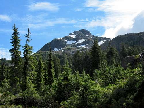 Klitsa Mountain west aspect Klitsa Mountain west aspect |
Year round thousands of cars stream along Sproat Lake on Highway 4 bound for Long Beach and the ever-popular resort towns of Tofino and Uclulet. Klitsa Mountain makes an impressive sight towering above the west end of the lake and few who make the drive could fail to notice the mountain. Ask 99% of them, however, and they probably couldn’t even tell you its name.
Klitsa and neighbouring Mt Gibson form the limits of a wonderful high alpine plateau well known amongst local outdoor enthusiasts as an empty, pristine and expansive alpine area that offers unparalleled hiking, climbing and especially skiing opportunities.
The summit of Klitsa has a well established cairn and a summit register in a brass canister administered by the Alberni Valley Outdoor Club. In spite of the relatively easy access, the register records show an average of only 4 or 5 parties per year visit the summit.
For many years the traditional route to the summit of Klitsa was via the northwest ridge accessed from the Taylor Main logging road off Highway 4 at the west end of Sproat Lake. Current summit log entries record, however, that almost all visitors now climb the mountain from the southeast via the “Brooke George Memorial Trail” which is itself accessed from that direction via the Nahmint Valley. This page will, therefore, describe what has become the de facto normal route.
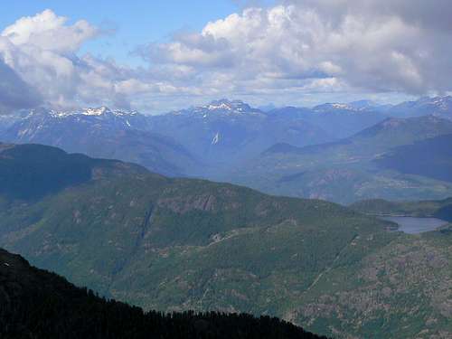
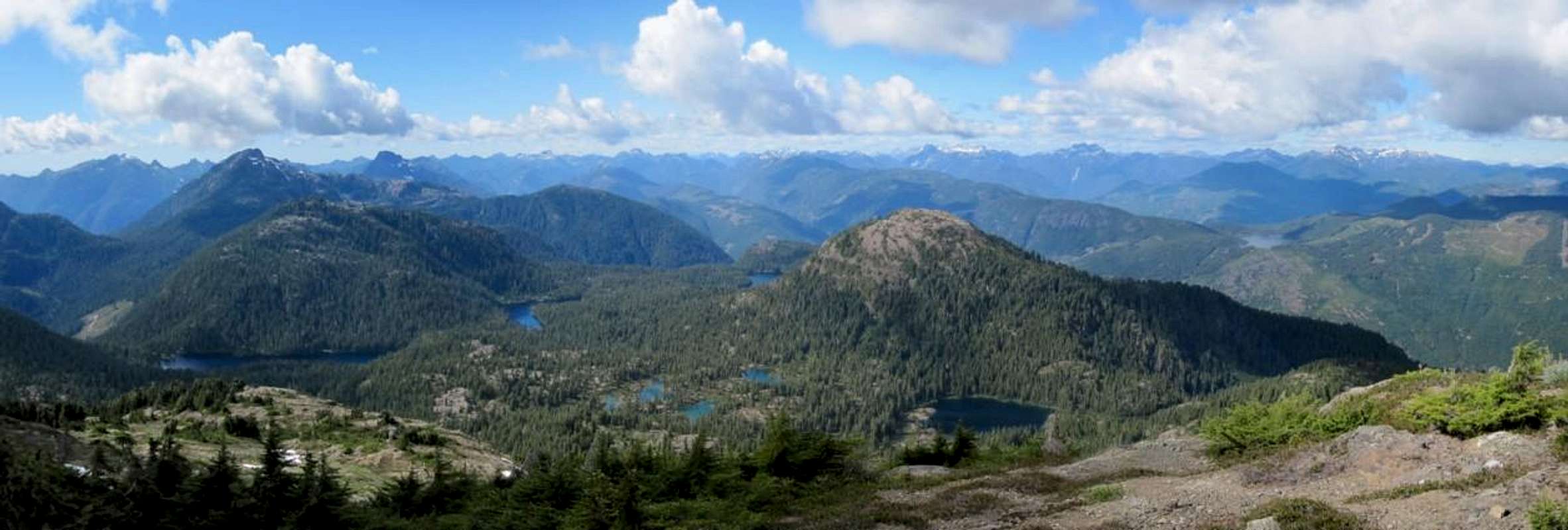
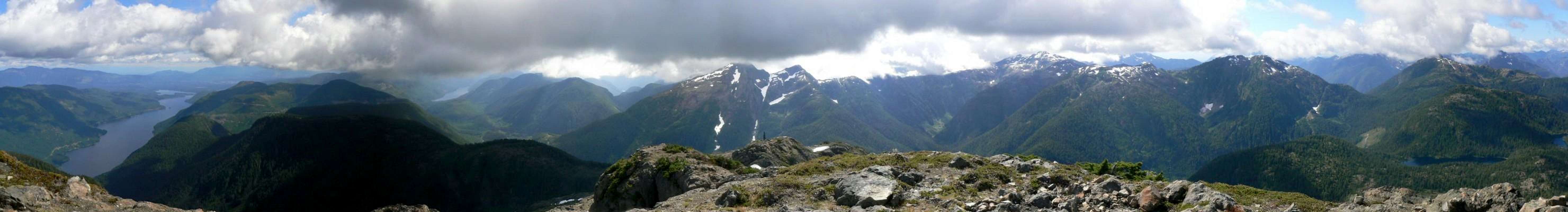
Summit views are excellent with Nahmint Mountain, 5040 Peak, Adder Mountain, Pogo Mountain and Steamboat Mountain in an arc to the west as the nearest neighbours. Highway 4 runs between Adder and Pogo but is unseen from the summit of Klitsa.
Distant views encompass the southern ranges of Strathcona Provincial Park to the north with The Comox Glacier, Mt Septimus and Big Interior Mountain particularly prominent. Given the right conditions, it’s even possible to catch glimpses of the Golden Hinde and Elkhorn over the left and right shoulders respectively of the Septimus massif.
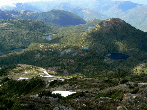
Gibson/Klitsa Plateau
Directly north of the summit and 400 metres below lies the lovely tarn-studded Gibson/Klitsa plateau.
Klitsa Mountain’s situation at the western head of Sproat Lake and proximity to the west coast of the Island translates into prolific winter snowfall. The mountain’s name is derived from the aboriginal word “Kleet-sah” meaning “always white”.
Getting There/Approach
Vancouver Island can be reached by air from Toronto, Vancouver, Calgary, Edmonton, Seattle and San Francisco to Victoria and by ferry from Port Angeles to Victoria on The Coho and on BC Ferries from Vancouver to Victoria or Nanaimo. Public transport on the Island is notoriously poor and anyone arriving by air would be advised to rent a car.Access in this case involves steep, rough, de-built logging roads with deep water bars. A 4WD vehicle with high clearance is essential in order to reach the very top of the roads that give access to the alpine. Chains may also be required if the roads are still under snow. This can occur well into May.
From Parksville or Qualicum Beach on the Island Highway 19, take highway 4 west towards Pt Alberni and Tofino. Pass the Mt Arrowsmith access road just after Alberni Summit and proceed down into Port Alberni. Go all the way down to the bottom of the hill and turn right at the signal light following signs for Tofino.
From the signal light at the bottom of the hill in Port Alberni drive 6.8 km and turn left onto McCoy Lake Road. Drive 1.9 km and keep right on Tyler Road. Go ahead 1.6 km to a 4 way junction at N49 15.254 W124 54.241 and go straight across onto gravel. Approximately 1 km later the road swings round to the west and begins to follow Taylor Arm, an offshoot on the south side of Sproat Lake.
Drive ~ 12 km along Taylor Arm and beyond and keep left at N49 14.018 W125 02.867, the junction with Taylor Main. Shortly thereafter the road will turn south (may now be called Gracie Main) and begins to climb up a pass ahead. Proceed 6 km up and over the pass and down to the junction with Nahmint Main at N49 11.720 W125 04.421. Turn right and cross the Nahmint River within 1 km.
Immediately after crossing the river keep right at a junction at N49 11.983 W125 05.223
Continue west on Nahmint on good 2WD surface and after 5.8 km cross the river again to its north bank at N49 12.810 W125 09.049
 Spur 600 approach Spur 600 approach |  Spur 600 drive limit Spur 600 drive limit |  Spur 600 washout Spur 600 washout |
Proceed further west on Nahmint for just over 4 km and find spur 600 on the right at N49 13.721 W125 12.017. Lock in 4WD, prepare to negotiate some deep cross ditches and drive spur 600 ~2 km to N49 14.032 W125 13.527 at an elevation of ~ 525 metres beyond which the road becomes un-drivable. There is adequate parking here.
Summit Route
From the drive limit walk 2 km northwest up the logging road to the trailhead at N49 14.652 W125 14.757 and ~ 800 metres elevation right at the edge of the old-growth.The trailhead is marked by a beautifully crafted sign made in memory of Brooke George, a respected and well loved member of the Alberni Valley Outdoor Club who died in tragic circumstances on Victoria Peak in 2007.
 West ridge trailhead West ridge trailhead |  Sub alpine tarn Sub alpine tarn |
Continue on excellent trail around the right side of the tarn and then turn east, north and finally east again as the path makes its way up into the alpine on Klitsa’s west ridge.
 West ridge West ridge |  Summit block Summit block |  Summit gully Summit gully |  Descending Klitsa Descending Klitsa |
Once the peak is in plain sight, it’s just a question of picking your best route east towards the summit block, although there are more than enough cairns and evidence of foot traffic to guide you.
As you approach the summit block a choice appears. Either go straight on up a steep gully or go round to the left to avoid any unpleasantness. Either option works fine and leads to a sub-summit a few seconds walk to the west of the main summit..
Descend the way you came up.
 Nahmint Mountain Nahmint Mountain |  5040 Peak 5040 Peak |  Adder Mountain Adder Mountain |  Red Pillar->Comox Glacier Red Pillar->Comox Glacier |
Approximate route data:
Total return distance: ~ 12.5 km
Net elevation: ~ 1,115 metres
Total elevation: ~ 1,150 metres
Ascent Time: ~ 3-4 hours
Descent Time: ~ 3-3.5 hours
As always a MapSource/Garmin tracklog is available for the asking for the approach and summit routes. Just send me an email or PM.
Red Tape and Safety Considerations
No red tape. You're on Crown land leased to a logging company.Make sure that you have left a detailed trip plan with someone responsible. The RCMP and the appropriate SAR agency will respond in an emergency but it is up to you to have the mechanism in place that will initiate the call-out process if it becomes necessary.
The town of Port Alberni is clearly visible from the summit of Klitsa Mountain and several members of the party I climbed with had cell phone reception from there.
Camping
Klitsa is usually a day trip objective. However, for an early start you may wish to camp at the trailhead. If so be aware that there is no ready source of water and that you should haul a barrel in there with you. If you’re upset by such things, I would add that the route start is home to one of the uglier end-of-road slash piles in my experience.Fires are strictly prohibited, so you must pack a stove. Bear and cougar frequent the mountains and forests of Vancouver Island, so proper back country methods – isolating food out of reach, cleaning up all cooking scraps, good toilet practice etc – are essential. Giardia is well documented throughout the Island, so boil or treat all water.
South Central Strathcona Provincial Park from Klitsa Mountain
Weather
Nearest points current conditions and forecast.West
East
Additional Information
The best map for this trip is BC Topographic Maps 1:20 000 map sheet 092 F024, “Adder Mountain”. Copies may be purchased from Cloverpoint Graphics (telephone 1 888 457 2724) and are sometimes available in good bookstores and outdoor stores throughout the Island.Suggested Reading
Island Alpine – A Guide to The Mountains of Strathcona Park and Vancouver Island, Philip Stone, Wild Isle Publications, 2003, ISBN 0-9680766-5-3 and/or visit Island Alpine Climbing Guide
Panoramas
  |
 |