

-
 14354 Hits
-
 84.82% Score
-
 19 Votes
|
|
Mountain/Rock |
|---|---|
|
|
36.90625°N / 118.46223°W |
|
|
Fresno |
|
|
Hiking, Mountaineering, Scrambling |
|
|
Spring, Summer, Fall, Winter |
|
|
12777 ft / 3894 m |
|
|
Overview
Pyramid Peak (South) is a unassuming peak sitting just north the Woods Creek drainage and west of the Sierra crest. While the peak has exceptional views of Mount Clarence King and the Rae Lakes basin, the views north to Arrow Peak and east to the crest are unremarkable. Pyramid Peak is one of the two Pyramid peaks of the 248 list peaks designated by the Sierra Peaks Section of the Sierra Club Angeles Chapter. The lower of the two, Pyramid Peak (North) is located in the Tahoe area of the Sierra. A fairly remote peak in the High Sierra, Pyramid Peak (S) is relatively easy to climb, after a long approach from any direction.The name “Pyramid” is popular for California mountains and so Pyramid Peak (S) is just one of a couple dozen peaks carrying the moniker within the state. Peter Browning’s Place Names of the Sierra Nevada attributes the naming to Joseph N. LeConte, the University of California, Berkeley engineering professor and noted Sierra explorer. LeConte is credited with climbing and naming a number of other peaks in the area during explorations of the South and Middle Forks of the Kings River area. A Climber’s Guide to the High Sierra (1954), edited by Hervey H. Voge, credits the first ascent to Art Reyman on a traverse from Window Peak in Jul 1942.
 Laura and Sean strategize on the easiest way to Pyramid from atop Arrow Peak (Sep 10)
Getting There
Due to its remote location, Pyramid Peak (S) can be approached from a number of different directions depending on the itinerary. The closest trail head approach is via the Taboose Pass trail although Sawmill Pass and Baxter Pass trails may not be that much farther. Entry into this region is also available from the west from Cedar Grove via Paradise Valley. Pyramid Peak has been day hiked (20+ hours) from Cedar Grove and the traverse from Window Peak appears to be popular even with the technical rating. North face viewed during an ascent of Arrow Peak (photo by Bob Burd)
Routes
There are a number of easy scrambling routes up Pyramid Peak (S) and probably many other undocumented routes that are possible. The precipice that’s the north face is just begging for some technical attention but the rest of the routes are in the easy scrambling range. |
West Ridge: The west ridge is actually composed of the main ridge and a spur southwest ridge that joins it at about the 12000’ level. From the north, class 3 slabs just left of the gully provide easy access. The spur ridge is a walk-up from either the south or the west. Class 2/3. |
 |
South Face: Is composed of various chutes that lead to the summit. Pick one. Class 2/3. |
 |
Southeast Ridge: Can be gained using several different approaches. A class 2 climb from either the east or the west up to the notch translates into a class 3 scramble to the top. The traverse from Window Peak is reportedly class 4 with a 5.4 crux. Class 3. |
 |
Northeast Ridge: Is most easily gained from the basin east of the peak, accessed from either Explorer Pass or the JMT along Woods Creek. The traverse from Explorer Pass over two subsidiary peaks has been done. Class 2/3. |
Red Tape, Camping, and Conditions
Everything you need to know about permits, regulations, and driving directions can be found on the Eastern Sierra - Logistical Center page. While overnight hikes require a wilderness permit, day hikes can be done without red tape. The parent SEKI page for this page also contains great information on the National Park.Climbing can be done in almost any season but May through October are the most popular times. In heavy snow years, the chutes and slopes may hold residual snow. This is also true for any of the routes over the Sierra Crest. Check for current weather.
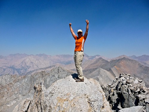
Laura celebrating her ascent (photo by Tom)
Postscript & External Links
Postscript: you may be wondering why I used so many pictures that didn't belong to me but to Bob Burd instead. It has to do with much more than the years of torture hikes he put me through. During the weekend that Laura and I made our ascent, the Sheep Fire near Road's End (a minor conflagration according to the NPS) was in full bloom. The mornings were usually fine as an easterly breeze kept the smoke contained. However, by just before noon the air current eased allowing the smoke to escape. Compare this picture I took here with one nearly identical here that Bob took.Trip Reports:
Bob Burd’s trip report
Climber.org reports
Pictures:
Laura’s pics & summary
Tom’s pics & summary