
-
 13571 Hits
-
 83.09% Score
-
 16 Votes
|
|
Mountain/Rock |
|---|---|
|
|
44.45094°N / 110.14275°W |
|
|
Park |
|
|
Hiking, Scrambling, Skiing |
|
|
Spring, Summer, Fall, Winter |
|
|
10245 ft / 3123 m |
|
|
Overview
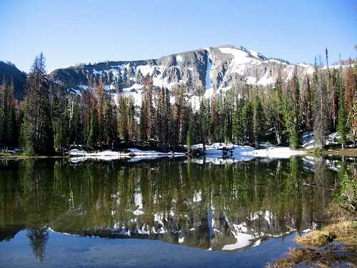
Top Notch Peak, named for the prominent gash between its north and south summits, is the backdrop to the pretty lakes of Yellowtone Park's East Entrance Road. But while hundreds of park visitors trudge up the barren screes of nearby Avalanche Peak, the prettier and wilder Top Notch is rarely visited.With a couple of hours to spare and a little confidence in finding your own way, you can walk the sweeping northeast ridge of Top Notch, cross the secret hanging valley east of the peak, and scramble to a clifftop vantage point with wide open views of Yellowstone Lake and down the park's untracked eastern margin.
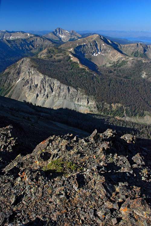
And if you've got more time, the summit of Top Notch is the gateway to the ridge leading onward toward Mts. Langford, Doane and Stevenson. Walking that ridge, with Yellowstone Lake spread out at your feet and the undulating grassy crest stretching on forever, is freedom itself.
Getting There
To climb Top Notch Peak, park at the Avalanche Peak trailhead parking. This marked pullout is located by Eleanor Lake about a mile west of Sylvan Pass on Yellowstone Park's East Entrance Road, on the south side of the highway.Routes
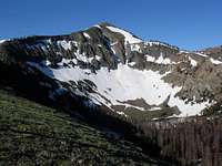
Regular Route--Northeast and Southeast Ridges: The most common route up the mountain starts from the parking area and diagonals across the slope above Eleanor Lake to reach the hanging valley directly north of Top Notch Peak. You'll find some intermittent game trails to assist you, but this is basically a bushwhack, and you'll need good navigation skills. After enjoying the pretty lake near the mouth of this valley, gain the toe of the prominent, open northeast ridge of the peak. Follow this due south for about a mile, until the ridge turns westward toward the summit. From here, the northeast ridge leads to a dead end at the north summit of the peak (not the true summit), from which crossing the "notch" to the main summit is loose, exposed, and difficult. It's better to abandon the northeast ridge when it turns west, instead continuing due south across the big hanging cirque east of the peak. A class 2 scramble gets you on the southeast ridge, which leads easily to the summit.
The cirque has a very flat bottom that until mid-season will be full of bottomless rotten snow, so it's generally best to cross right along its outermost rim, along the top of the breccia crags dropping down to Middle Creek.

Northwest Route:
Alternatively, from about halfway between Sylvan and Eleanor Lakes, light bushwhacking gets you on a timbered ridge that hits the main Top Notch-Grizzly Peak ridge about halfway between the two summits; from there, walk the main ridge through scrubby trees to the summit of Top Notch. This ridge goes directly to the true summit, so you avoid the notch this way.
The north ridge--the one that appears to lead straight from the Avalanche Peak trailhead parking to the summit--dead-ends at the notch.
Map
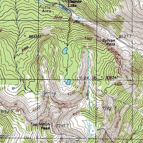
This map, submitted by SPer Matt Horbal, shows a GPS track of Horbal's 2008 climb. He used a variant of the regular route to the summit--he started at the opposite end of Eleanor Lake from the Avalanche trailhead. This works, but the bushwhacking is a little steeper and harder.
Red Tape
There is essentially no red tape for a day trip up Top Notch, apart from the need to pay the Yellowstone Park entrance fee when you enter the park. For overnight trips, see "Camping."
Camping
A Backcountry Use Permit is required for all overnight trips in the backcountry of Yellowstone. It costs $20 and must be obtained in person. Furthermore, these permits are generally granted only for a set of "designated campsites," and there are none of those in the Top Notch backcountry.The Park Service allows camping in undesignated sites "occasionally" when the camper obtains "special approval." Therefore, if you are interested in camping on Top Notch (such in pretty hanging cirque east of the peak), you will need to obtain this special approval. I think it is somewhat unlikely to be granted for a destination as close to the road as Top Notch. Inquiries can be made by e-mail to YELL_Backcountry_Office@nps.gov .