
-
 33199 Hits
-
 92.56% Score
-
 39 Votes
|
|
Mountain/Rock |
|---|---|
|
|
61.04149°N / 149.66792°W |
|
|
Hiking, Scrambling |
|
|
Spring, Summer, Fall, Winter |
|
|
4311 ft / 1314 m |
|
|
Overview
McHugh Peak anchors the southern terminus of the “front range” of Chugach Mountains that form the backdrop for Anchorage, Alaska. Beyond McHugh, Turnagain Arm slices through the mountains and the margin of the range turns eastward along the water’s edge. Though it is not among the higher Chugach peaks, the unbroken 4300-foot rise from tidewater gives it a dramatic summit that is well worth seeking out. The popular hiking guides for the Chugach Mountains either ignore McHugh or contain a good deal of outdated and wrong information about it. This page is an attempt to get some better information out there.
Getting There
There are currently two main trailheads for climbing McHugh that have completely independent approaches by road. They’ll be describes separately with their respective routes below.
Summit Views
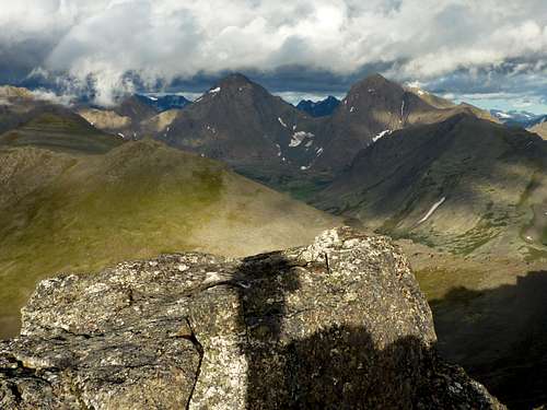 Eastward to the Suicide Peaks
 Southward across Rainbow Peak and Turnagain Arm to the Kenai Peninsula.
Regular Route
 Parking for N Ridge
North Ridge—the McHugh Peak Trail: This trail offers the easiest ascent of McHugh. It is mostly a ridge walk, with fantastic views of the Suicide Peaks on one side and across Cook Inlet to the Aleutian Range on the other. Because parking is extremely limited, you'd better have a backup plan whenever you set out to do this route. If the weather is decent and it's a weekend day, your chances of scoring a parking place are slim to none.
To reach the trailhead, drive east on Rabbit Creek Road (this road is the last exit from the Seward Highway as it leaves the south end of Anchorage). When the road bends left after three miles, turn right onto Clarks Road and immediately right again, still following Clarks Road. Follow this road into Bear Valley, continuing past where it turns to dirt and crosses a stream. Turn left on Snowbear, right on Black Bear, and left on Honey Bear. Follow Honey Bear all the way to the T junction at its end, passing through a large, always open gate with “no outlet” and “no trespassing” signs (don’t worry about the signs—there is a legal right of way for trail users).
At the T junction, turn right and drive 100 yards to a turnaround circle. The trailhead is here. Be very careful parking in the circle. Legal parking is marked. Although there was originally room for six vehicles, the parking zone has been constricted and "striped" (perhaps by nearby residents), and now it accommodates only four to five. Do not park anywhere else nearby; your car will be ticketed, towed, or vandalized, or maybe all three. Because parking is so limited, try to park carefully so that none of the legal space is wasted. If you find that there is no room at the circle, there is legal, official overflow parking available one-half mile back the way you came, on the north shoulder of Honey Bear below the big gate. Starting from the overflow parking adds 350 feet to the total ascent.
A well marked and constructed trail leaves from the circle and climbs 1100 feet on switchbacks to the crest of McHugh’s north ridge, at 3200 feet. Continue southward along the ridge crest, always heading for the prominent rock tor, shaped like a cockscomb, on the summit of McHugh. The tor itself requires a very short class 2-3 scramble on its north side or east end.
The net climb from the trailhead to the summit is 2200 feet. With the ups and downs of the ridge, however, you will have climbed about 2450 feet to gain the summit and 2700 feet by the time you complete a round trip. The six mile round trip requires three to five hours of hiking time.
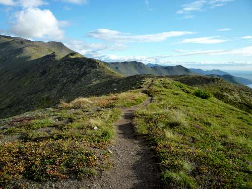 Once on the north ridge, the McHugh Peak Trail is a wide-open ramble
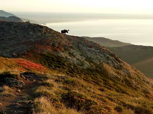 Southwest toward the Kenai Peninsula from the north ridge
Other Routes
South Flank: This is much more arduous than the regular route up McHugh, involving a 4300-foot elevation gain. Park at McHugh Creek wayside at Mile 112 on the Seward Highway south of Anchorage. Follow the Turnagain Arm Trail half a mile west (toward Potter Marsh) and turn right at the marked junction onto the McHugh Lake Trail. Follow this pleasant trail on switchbacks through the woods for about a mile and a half to elevation 1300 feet and turn left on a rubble-filled scar of a trail heading straight uphill.This path improves somewhat and leads through a cirque popular with Dall Sheep and onward to the crest of McHugh's southwest ridge. Turn right on the ridge and walk it nearly two miles, passing over Point 3491, until you can go no higher. Some bushwhacking and slow ridge travel is involved. (By this route, you can alse access the delightful peaklet called "Caballo Blanco", 3240', by turning left when you reach the main ridge.)
In 2020, following the 2016 McHugh fire, there are great open slopes from a point about two miles up the McHugh Lake Trail, allowing a variant of the above route in which you to hit the southwest ridge at a point closer to the summit. It's still a challenging off-trail route with some scrambling, requiring 3-4 hours one-way from McHugh Creek wayside.
 Just beyond brushline on the Northwest Ridge, January.
Northwest Ridge: The northwest ridge (the ridge north of Potter Creek, anchored by Point 2379) used to provide an excellent 3100-foot ascent. From the little pass between Point 2379 and McHugh Peak, there is a path on the northwest ridge leading to the park boundary. The main, ascending portion of the ridge, which is within Chugach State Park, is class 2 as far as the tor. In addition to summer hiking, the northwest ridge can be a fun and relatively safe winter route.
In the past, the northwest ridge was usually accessed using the gated, abandoned Stewart Homestead Road that contours along the ridge above Potter Creek, then using one of two jeep roads connecting that road to the ridgecrest. Stewart Homestead Road traverses several private tracts. In the past, the landowners traditionally welcomed hikers and bikers along the road, the great majority of whom were their neighbors from that part of the hillside.
However, on March 28, 2013, Frank and Oksana Pugh, who own the first tract that must be traversed, made the following public statement: "We recently purchased the property ... which represents the first approximately 0.6 miles along the private ... 'Stewart Road'.... After purchasing the property, we posted 'No Trespassing Signs' which are typically ignored by hikers using the area. We have no interest in providing public access across our property ...." Although there were recorded easements that allowed certain individuals to cross the Pugh tract, it was not clear whether there was an easement that would make it acceptable for a member of the public to do so without express permission. This page therefore advised the public to stay away.
The Municipality of Anchorage claimed that there was indeed and easement, explained its claim in detail, and asked the Pughs to remove their signs. The Pughs refused, and became confrontational with people crossing the property.
On September 1, 2022, Superior Court Judge Dani Crosby ruled that there is indeed an easement for hikers to traverse the Stewart Homestead Road. View the order here.
![Summit Tor]() Final objective--the summit tor
Though not significantly restricted, camping is not very practical on this mountain.
Final objective--the summit tor
Though not significantly restricted, camping is not very practical on this mountain.
East Peak
McHugh has a second summit about a mile to the east. Only a few feet lower than the main summit, and with a prominence of about 300 feet, it deserves a separate identity but doesn't have one. It is best climbed up spongy tundra slopes from the end of the Echo Canyon Trail or via an easy tundra stroll from the plateau below the main peak. If you choose the long, pretty east ridge from Rabbit Lake (class 2), be aware that it is slow going--allow a couple of hours or more, each way.Red Tape
There is a $5 fee to park at McHugh Creek trailhead (the trailhead for the South Flank route), unless you have an annual pass. You will need exact change. There’s no fee at the other trailhead. Overnight parking at the Honey Bear/North Ridge trailhead is forbidden. At the south flank trailhead, the gate locks (no joking) at 9:00 p.m. hours before summer sunset times, and you'll be locked in unless you have parked outside of it.Camping
 Final objective--the summit tor
Bears
Two people have been killed in surprise grizzly bear encounters on McHugh Peak. Take full bear precautions until clear of the brush, particulary on the south flank and northwest ridge routes. The north ridge route has only a few hundred yards in the brush, so surprise bear encounters are less of a concern.Weather
A recurring weather pattern in Anchorage is “high winds along the hillside” that tear around the corner between Turnagain Arm and the upper slopes of the Anchorage bowl. McHugh Peak is the corner that seems to bring these winds to their maximum ferocity, and it is not uncommon to encounter winds strong enough to blow you off your feet and pelt you with gravel.Pick a calm day for this one!
In winter, the high winds often just about scour the snow completely off McHugh. This can create its own hiking issues, but when it occurs, at least you won't have to worry so much about avalanches.
2)Article describing the battle over Stewart Homestead Road access