
-
 18237 Hits
-
 88.19% Score
-
 26 Votes
|
|
Mountain/Rock |
|---|---|
|
|
48.90451°N / 121.55376°W |
|
|
Whatcom |
|
|
Hiking, Mountaineering, Skiing |
|
|
Spring, Summer, Fall, Winter |
|
|
6688 ft / 2039 m |
|
|
Overview
 The Southeast Face The Southeast Face | Distance: 12.5 miles round-trip Accumulative Elevation Gain: 4900 feet Difficulty: strenuous, partially off-trail Granite Mountain is a seldom visited peak 43 miles east of city of Bellingham and 8 miles south of the Canadian border. Why is this peak an unusual destination even though it has 668 feet of prominence? Several factors are likely responsible. The main reason is that the approach is long and partially off-trail. Furthermore it's necessary to pass over the summit of neighboring Hannegan Peak along the way. It's likely that Granite was first ascended in 1901 by Smith and Calkins. |
But let's get honest here. Who wants to climb another Granite Mountain??? Come on, somebody... Anybody? I guess not. There are 12 of them in the State of Washington alone. It's one of those common names that's just not very exciting, like "Bald Mountain". If you tell your buddies you did Granite they'll assume you mean the popular one located off Interstate 90. If you mention that it's located in the North Cascades they're eyes will glaze over and they'll say "Huh? What are you talking about?" This peak is a good choice for folks who have done a lot and are still looking for something new.
Bordered by Ruth Creek on the southwest and Middle Fork Silesia Creek on the northeast, Granite Mountain is part of a system of ridges which connects to Hannegan Peak and Ruth Mountain in the southeast and Mount Chardonnay, Mamie Pass, and Goat Mountain in the northwest. The south and west sides of the mountain are sloping and well forested below but the upper slopes are covered with blueberries, alpine grasses and, wild flowers. The northeast face is different story. The bedrock here is very much exposed. Near the summit and ridges, near vertical granite cliffs drop down to far-spanning granite talus slopes. |  Views From The South East Ridge Views From The South East Ridge |
The Route
This stretch of land at the northern end of the Cascade Range is a particularly spectacular part of Washington State. Some climbers claim that the Cascades becomes more scenic the further north you go. The first objective is the summit of Hannegan Peak (6187 feet). From the parking lot the trail traverses the north side of a long valley with Ruth creek running below. Waterfalls tumble down from glaciers along the side of Mount Sefrit and Nooksack Ridge. The, gradually Ruth Mountain comes into view after the first mile. The trail is very well graded all the way to Hannegan Pass which is one of a few of the main gateways to the Picket Range.
At the pass there is a junction. Turn left for Hannegan Peak. Continuing east would lead towards Mount Challenger, the Northern Pickets, and Ross Lake while turning right would go to Ruth Mountain and/or Icy Peak. Follow the trail for another 1,200 vertical feet up to the summit of Hannegan Peak. With good weather, Granite Mountain is now visible and clearly a loftier and more rewarding summit. A fairly good boot path continues northwest from the summit of Hannegan Peak. There are three distinct high points along the ridge. The first and largest, Point 6135, should be passed over.
 The Base Of The Southeast Ridge
The path might become intermittent at times but it is generally easy to follow. Even if the path didn't exist, with Granite Mountain visible, the direction of travel is obvious. In a couple of spots it may be necessary to navigate through a few tree branches. With the lowest saddle on the ridge at 5700 feet, only 490 feet is lost between Hannegan and Granite. At the base of Granite's southeast ridge the path disappears completely. Now prospective peakbaggers are on their own.
Ascend grassy slopes staying on or just west of the ridge crest avoiding small patches of trees as necessary. There should be little to none in the way of scrambling with the possible exception of one or two very short and easy moves with a minimum of exposure. At the summit several blocky rocks are interesting to explore. The pointed one is the high point and is easy to scramble up. A small cairn is near the high point and someone has left a stone there with the message: "Time is not gliding away. It builds up in your mind".
 Nearing The Summit
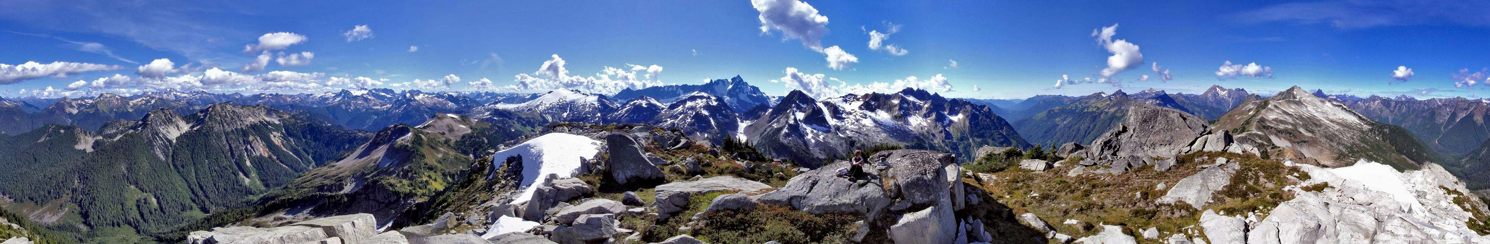
The views from the summit include Church Mountain, Excelsior Peak, Goat Mountain, Tomyhoi Peak, Winchester Mountain, Mount Larrabee, The Pleiades, Mount Chardonnay, Slesse Mountain, Pocket Peak, Mount Rexford, Blink Mountain, Copper Mountain, Mount Redoubt, Indian Mountain, Redface Mountain, Whatcom Peak, Mount Challenger, Crooked Thumb Peak, Phantom Peak, Mount Fury, Mineral Mountain, Ruth Mountain, the Nooksack Tower, Mount Shuksan, Mount Baker, Mount Sefrit and many more. Good campsites are available a half mile before the pass at Hannegan Camp, and also on top of Hannegan Peak.
Getting There
|  The View Of Ruth Mountain The View Of Ruth Mountain |
Red Tape / Restrictions
 Mount Chardonnay and Slesse Mountain From The Summit
A Northwest Forest Pass is required for each vehicle parked at the Hannegan Pass trailhead $5 per day or $30 for an annual pass.
Where to get PARKING PASSES:
- SHELL GAS STATION: in Maple Falls, is on the right (heading East). They make good pretzels too. ---NO GASOLINE AVAILABLE BEYOND THIS POINT!!!--- no gas between Maple Falls and Deming (heading West).
- GLACIER PUBLIC RANGER STATION: (360) 599-2714 On the right (heading East) as you leave the town of Glacier.
- Bellingham REI: (360) 647-8955
400 36th St Bellingham. Take a left off exit 252 (WWU-Bill McDonald Parkway), another left, it's in the Haggen lot.
Closed for the season after Oct. 11
When To Climb
Depending on conditions Granite Mountain can be climbed all year. Hannegan Road is buried under snow for much of winter, but the road is an easy ski and melts out early, check the snow level to get a rough idea how far you can get up the road. There is significant avalanche hazard in this area in winter, as well as wet slab avalanche hazards in spring. Expect to spen the majority of your travel time on south and east facing slopes. Make sure conditions on these slopes are good before you leave and check NWAC predictions before you go. DO NOT travel in the backcountry if you are not educated and experienced with the present dangers. Be extra careful when crossing creeks and drainages on snow bridges. Remember to be wary of cornices along the ridge crest. Generally the period from early May until October is the best time to climb. Where To Camp / What To Bring The View Of Mount Sefrit The View Of Mount SefritThere are nice car-camping sites and facilities at the trailhead. Campsites are available a half mile before Hannegan Pass at Hannegan Camp (backcountry toilet here and at Hannegan Pass). There is also a campsite on top of Hannegan Peak as well as a few other bivy spots. In summer this is just a hike but you may encounter some snow, an Ice Axe or at least trekking poles are a good idea before July. Mosquitoes are bad up until late July at which point you will encounter millions of flies, so bring some repellent! In winter or spring snowshoes and or crampons may be necessary. Trekking poles and an Ice axe are mandatory, especially if you decide to do Ruth Mountain as well. There are some slopes that would be suspect in avalanche conditions so keep that in mind, a shovel, beacon, and probe wouldn't hurt. This route is easier to follow than others in the winter. Remember to watch for cornices on the north side of the Granite-Hannegan ridge. There are no glaciers on Hannegan or Granite, so glacier gear is unnecessary unless you plan to hit Ruth on the way out. |