
-
 27044 Hits
-
 96.11% Score
-
 57 Votes
|
|
Mountain/Rock |
|---|---|
|
|
61.00911°N / 149.54547°W |
|
|
Hiking, Mountaineering, Scrambling |
|
|
Spring, Summer, Fall |
|
|
4435 ft / 1352 m |
|
|
Overview
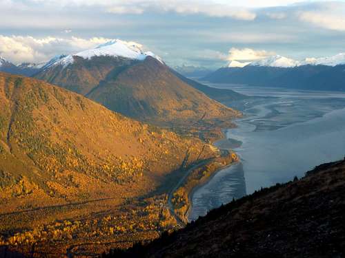
Indianhouse Mountain is a scrambling peak near Anchorage, Alaska, spectacularly sited above Turnagain Arm fjord. It is the highest and most rugged of the buttresses that hang directly above the north wall of the fjord and, being a little more difficult than the other buttresses, it doesn’t get much traffic.The regular route takes you over the kind of high meadows with a water view that just take your breath away, and then onward to the mountain's appealing, multi-pinnacled spine.
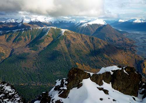
View from near the southeast shoulder, on the way up
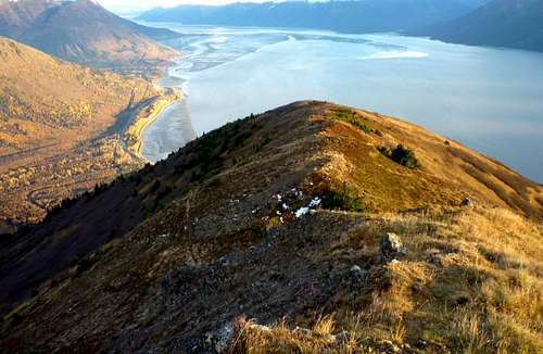
Looking south along the spine of Indianhouse
Getting There
Indianhouse Mountain is located approximately 20 miles south of central Anchorage along the Seward Highway (Alaska Highway 1). The primary trailhead is the pullout at mile 104 (described in “Regular Route” below). The less frequented west face and ridge are accessed from the Falls Creek trailhead at mile 105.6.Routes
Regular Route: The easiest way up Indianhouse entails gaining the southeast shoulder of the mountain and then traversing the east face to the central couloir. To get on the southeast shoulder, you’ll have to be willing to tackle a little heavy bushwhacking and be confident of your navigation skills. I’ve done it four separate ways, and I’m pretty sure that the method described below, variant B, is the best there is … if you can find it. Oh, and bring the bear spray and your loudest singing voice. The game trails on Indianhouse can be so covered with bear scat that it is actually a slipping hazard.Just west of the Indian Valley Mine, at approximately mile 104 of the Seward Highway, there is an unmarked turnout on the uphill (north) side of the road. Park here.
Ignore the path at the center of the turnout. A trail enters the woods at the east end of the turnout. Follow this. It climbs gently eastward for about a hundred yards, then switches back and climbs westward. At about ¼ mile it abruptly levels out. Here you have two options:
The southeast shoulder, 2500'
Option A. Bushwhack directly up the fall line for 1000 vertical feet, diverting only enough to take advantage of a few steep, discontinuous game trails you will encounter. As the trees thin out, you should intercept a well-established trail of use that ascends from left to right across the slope. Follow this.
Option B. Continue west on the main trail. This is the Old Johnson Trail, a historic route (other parts of which—but not this part—have been renamed and incorporated in Chugach State Park’s Turnagain Arm Trail). Follow the Old Johnson Trail about half a mile. It passes under an east-west power line and travels above the line for a time. You’ll see a prominent cliff band far above, descending from right to left. As the trail continues, it again passes under the power line to travel below it, and goes out onto a treeless corner associated with the toe of the cliff band. Now start looking for a path cutting sharply upslope and back to the right (east). Follow this as it zigzags very steeply along the ascending upper margin of the cliff band. At times it's more of a scramble than a trail. Eventually you reach the apex of the cliff band where there is a brushy shelf. You need to travel east, across the shelf, to join the trail mentioned in A. This is where it gets a little tricky. There is a sheep trail that makes this link, but you’ll be hard pressed to see the full connection your first time up. Don't stray more than about 20 yards from the clifftop as you traverse. With luck, you’ll find the trail mentioned in A within 50 yards.
Now continue up the human trail to the crest of the mountain’s southeast shoulder, a grassy, level ridgetop. The topo puts this at 2500 feet, but the actual height is more like 3000. Enjoy the unparalleled views from this perch above the fjord, which makes a fine destination on its own.
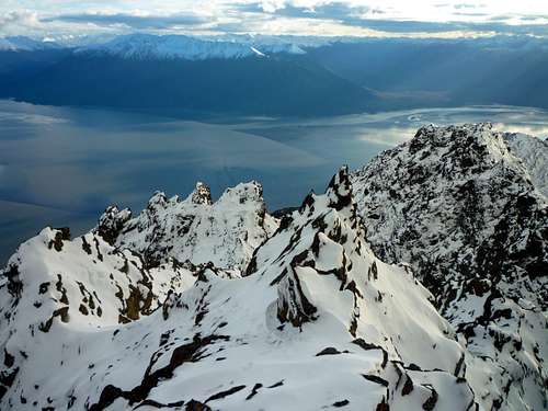
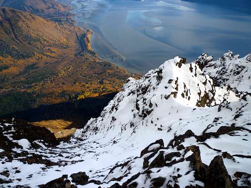
From the shoulder, you need to traverse the east face for two thirds of a mile to the very prominent central east face gully, which runs up to a deep notch in the summit ridge (the gully is the obvious feature at the center of the picture at the top right corner of this page, and is shown in more detail here). Do this traverse without losing elevation, taking advantage of helpful sheep trails. Beware of avalanche danger in early season.
Climb the center gully for at least 1000 vertical feet. If it’s snow-filled, you’ll want an ice axe for self-arrest—the snow angles reach 40 degrees. In late season it is snow-free and is a class 3 scramble with no serious exposure. Just before the gully tops out (no more than 100 vertical feet from the crest), you’ll see a narrow couloir (almost a chimney) to your right. Follow this—more class 3—to the summit ridge, and walk it northward to the summit.
A map at the bottom of this page shows the regular route. With 4400 feet of elevation gain, some bushwhacking, and lots of inefficient sidehilling, the route will take most parties 3-5 hours to complete.
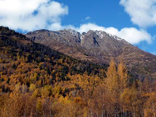
 West face, Oct. Click for detailed view.
Other routes: If, instead of traversing the east face from the southeast shoulder, you continue up the shoulder onto the main south ridge, you’ll get very high on the mountain without much difficulty. However, there are two notches to cross to reach the actual summit. The first is third class, and the second is class 5.
The northwest ridge from Point 3920 is said to be hard 4th/easy 5th class. There is a description here and another here.
The west face, accessed by the Falls Creek Trail, might offer a very, very steep snow route in early season, but seems to be rotten and unstable. At the south end of the face, however, there is pleasant, grassy access to the toe of the south ridge (at the col with Point 3772), which you can cross to link with the southwest shoulder.
Aprés Indianhouse
At the foot of Indianhouse Mountain is the legendary Turnagain Arm Pit, where you can get the finest Texas-style barbeque in Alaska. The servings are huge, and “pit masters” Jack Goodsell and Todd Marcum are fun to talk to about their project to bring good barbeque to the far north. If you don’t take my word for it, check these reviews:AK Cuisine
Urban Spoon
Summit Views
The village of Indian from the summit
Eastward from the top: Bird Ridge in foreground, Nest and Penguin Peaks behind.
Camping
Indianhouse Mountain from the Turnagain Arm Pit
Not practical on this mountain except in the pretty bowl below the west face that is accessed via Falls Creek. Campfires are prohibited.
There is car camping just a few miles east at Bird Creek.
Red Tape
NoneWeather
For more accurate real-time conditions at the base, click here.
Links
A trip reportAnother trip report
Chugach State Park Map
Seward Highway video
Route Map
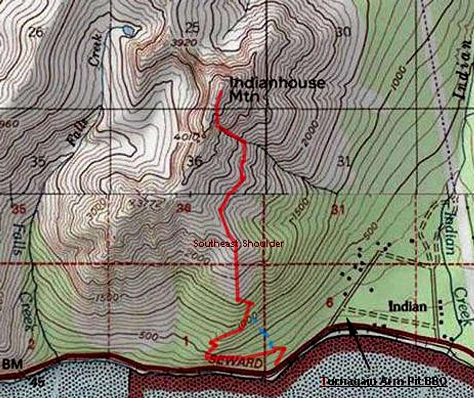
The regular route, option B, is shown in red. The more direct Option A is shown by the blue dashed line.