
|
|
Mountain/Rock |
|---|---|
|
|
56.75583°N / 5.00376°W |
|
|
Highland |
|
|
Hiking, Scrambling |
|
|
Spring, Summer, Fall, Winter |
|
|
3606 ft / 1099 m |
|
|
Overview
| Sgurr a’ Mhàim (3605 ft) is a mountain located five and a half kilometres north north-west of Kinlochleven in the Lochaber region of the Scottish Highland area. | |
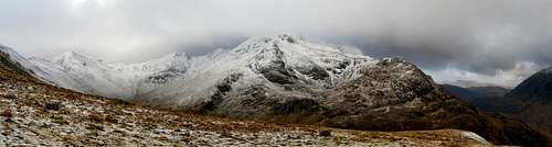 | |
| Sgurr a’ Mhàim is a Munro (51 of 283) and the second highest peak in the Mamores range. Meaning of the name: from the Gaelic, peak of the large rounded hill. The finest feature of the Sgurr a’ Mhàim is a south ridge known as the Devil's Ridge: | |
 | |
Getting There
Mountain is located not too far from Glen Nevis (Fort William) in Scotland. You can fly to Glasgow from most of the European airports and then drive (about 3h) or take the train. Also Citylink (www.citylink.co.uk) operate a bus service between Glasgow and Fort William.Red Tape
One of the joys of visiting Scotland is to appreciate their long standing culture of their ‘no trespass law’ in which so long as nothing is disturbed you will have the right to wander the land as you please.Camping
If you are planning on wild camping, do so responsibly in a way that has a minimal effect on the environment.The nearest camping site is Glen Nevis Caravan & Camping Park (Glen Nevis, Fort William, PH33 6SX) and I can recommend SYHA Hostel in Glen Nevis

Routes
The best place to start the hike is Achriabhach in Glen Nevis. First, follow the stalker's path towards Coire a' Mhusgain for a short distance and then turn directly up the north-west shoulder of Sgurr a' Mhaim which gives a long steady climb to the summit on the grassy slopes and then on boulders and scree. You will be able to see the Ben Nevis and the Carn Mor Dearg (East Ridge of Carn Dear Meadhonach) on your left hand side for most of the time.
The Ring of Steall
The Ring of Steall (16km/10 miles) is a classic mountain route combining the traverse of four Munros with scrambling along narrow, rocky aretes. The route begins in An Gearanach, Stob Choire a Chairn, Am Bodach and then follows the Devils Ridge to Sgurr a'Mhaim.
Map
External links
Weather forecast for the summitWikipedia page
Also please watch this video to see more about Scottish mountains: