
|
|
Mountain/Rock |
|---|---|
|
|
39.34581°N / 119.60526°W |
|
|
Storey |
|
|
Hiking, Scrambling |
|
|
Spring, Fall, Winter |
|
|
7036 ft / 2145 m |
|
|
Overview
Peak 7036 is a rocky summit in the Flowery Range; an offshoot of the Virginia Range of Northwest Nevada.Views from the summit are spectacular, with mountains on all sides, including views of the surrounding mountains in the Virginia Range and Flowery Range, as well as excellent views of the Sierra Nevada, the Pine Nut Mountains, and the Pah Rah Range.
The primary route is from the southeast. There are a couple other routes with some access issues. The slightly shorter northwest route is also described below, which starts on BLM lands, but involves more bushwhacking. The most direct route (from the north), is described as well.
Once atop Peak 7036, the highest peaks of the Flowery Range are in view, including Rocky Peak 7082’, Horse BM 7163’, Tibbie Peak 7277’, and the Flowery Range HP 7337’. It is possible to do a combination from the southeast route or the northern route, but hiking these peaks will add significant hiking time.
The best time to hike up Peak 7036 and the Flowery Range in general is probably late fall (November, December) and late winter/early spring (February, March, April). During summer, temperatures are far too high. The area gets pretty snowy during the heart of winter.
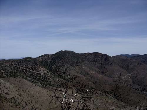
Peak 7036 from the summit of Flowery Peak
Getting There and Route from the southeast approach
From Reno, Nevada take 395 to exit 57B, or take exit 61(Virginia Street) and drive south. Either way leads to Highway 341, the Geiger Grade. The Geiger Grade is a mountain pass road from Reno to Virginia City. It winds through the hills of the Virginia Range for about 15 miles after leaving Virginia Street in south Reno. Once in Virginia City, look for signs to Six Mile Canyon Road. This is a narrow paved road that leads from Highway 341 to US Highway 50 in the Dayton Valley. Continue down the road, and drive past the Sugarloaf Rock Formation on the left. Continue for 1 ½ miles. There area couple roads in the area near mining operations. One has a No Trespassing Sign. The one just past it has no such sign. There are large power lines at the base of the road.
The road starts at only about 4770’ or so. Follow the power line road for about 2 miles. There is then a “Y” junction. Take a left and head up to the ridge. Once on the ridge continue west (left)towards Peak 7036. You will descend to a road heading up towards the summit of Peak 7036. It comes within about 200’ of the summit. You have to bushwhack/scramble the rest of the way, which is pretty easy.
All told it is about 7 1/4 miles round trip from the power line road, with a one-way elevation gain of over 2,550’. You can also loop it to gain the ridge by heading right at the "Y" Junction towards Rocky Peak. That only adds about three-quarter miles total to the trip as you will reach the ridge and then walk up to the power poles on the left and gain the road.
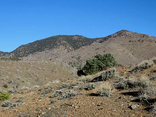
View of Peak 7036 from the southeast approach
Getting There and Route from the northwest approach
From Reno, Nevada take 395 to exit 57B, or take exit 61 (Virginia Street) and drive south. Either way leads to Highway 341, the Geiger Grade. The Geiger Grade is a mountain pass road from Reno to Virginia City. It winds through the hills of the Virginia Range for about 15 miles after leaving Virginia Street in south Reno. Once in Virginia City, look for signs to Six Mile Canyon Road. This is a narrow paved road that leads from Highway 341 to US Highway 50 in the Dayton Valley. The parking area is a dirt road about 1 ½ miles down the road from Virginia City. The dirt road is located on the north side of the Six Mile Canyon road (left side of the road if coming from Virginia City). Find a place to park on the dirt road, just past the pavement.Follow the dirt road as it heads straight north. About 1/3rd of a mile up the road, several dirt roads cut to the right and up the slope. Follow these roads as they wind northeast up the hillside. There is a point about ½ mile up where the road has a u-shaped turn. Just when the road turns back the other direction, another road heads to the left side of Flowery Peak, the mountain's summit above the road.
After about ½ mile and 335’ of elevation gain, you reach a saddle between two pointy summits, just north of Flowery Peak. Continue on the road. Head to the left of the pointy summit to the north. The road descends about 100’ in ½ mile and ends at a T-junction. Head directly up the slope for about 320’ and you reach a road just below Long BM 6861’. Take a right on the road, and follow down for roughly ½ mile until you reach an old abandoned house. Directly across the house is a dirt road. Follow it for about 250 yards, and then leave the road on its left side and bushwhack up to Point 6590. From here you can see the summit less than a mile away. It is pretty obvious how to get there. You must descend and climb another slope, and then you can head cross-country through the woods directly to Peak 7036.
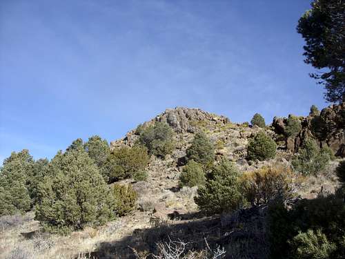
Looking at the open area just below the rocky summit.
Once at the base of the rocks, it is an easy scramble up to the summit. From the summit, you can see a road below that is an obvious way back down which connects to the road you take below Long BM. However, the road is private and listed as “no trespassing”. Therefore, you must descend the way you came.
All told it is about 7 miles round trip from the parking area on BLM land, with a one-way elevation gain of a little under 2000’. Add Flowery Peak on the way and it becomes 8 ½ miles round trip and adds just under 700’ more of elevation gain.
Getting There and Route from the northern approach
Two miles north of Virginia City is Lousetown Road. Lousetown Road is part of a private residential area. There are homes at the base of Peak 7036 that complicate the shortest routes. I did take the shortest route once, and walked near a house. I don't recommend it. Perhaps the safest way is actually off of Long Valley Road. That road has a nasty sign at the entrance. Yet, that likely refers to walking by the homes themselves. Take this dirt road about 2 miles where it turns into Barrel Springs Road. Then continue straight for another 1/3 mile and park at 39.363, -119.5895 at about 6,030'. Note that there are a few homes and some nasty signs. But this area is visited by 4WD vehicles and you should be fine if you stay off private property.
Get past the house by hiking well up on the side, which is easy from the parking area. Get back down to the road past the house so as not to disturb anyone. Then after less than half a mile from the car there is a fork in the road. Take the right fork. After about 0.85 miles, there is a road on the right heading up towards Peak 7036. The summit is about 0.9 miles further. You have to bushwhack the final part. The total one-way distance is about 2 1/4 miles. The elevation gain is a little over 1,000'. You can mix it up by taking a different road back, heading up to Point 6,776.