
|
|
Mountain/Rock |
|---|---|
|
|
39.27310°N / 114.1988°W |
|
|
White Pine |
|
|
Hiking |
|
|
12067 ft / 3678 m |
|
|
This is to replace the page that was deleted by a SP member who deleted all his mountain pages. Those of you who had pictures and summit log entries on the prior page are welcome to add those to this page. Signature pic by gjagiels.
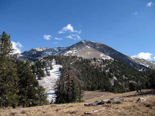
Northwest Ridge
Overview
"...and they call the wind Moriah". Why is it that that tune from Paint Your Wagon hits me everytime I see Mt. Moriah from a distance? Every time.
Mount Moriah is one of Nevada's highest mountains and would probably be better known if it wasn't for the big guy just to the south, Mount Wheeler. Mount Moriah is the 5th highest mountain according to this list. It is also the 9th most prominent peak in Nevada as shown by this Nevada top 100 list. With 4927' of prominence, this one misses being an Ultra by less than 73 feet. There are some who feel that depending on where it was measured from, that it might be even closer than that. Still, Mt. Moriah ranks as #59 on the top 100 prominence peaks list of the lower 48.
Located in the Humboldt National forest, a portion of which has been set aside as the Mt Moriah Wilderness area. The 80,000-acre Mt. Moriah Wilderness was established December 5, 1989, is located north of the Great Basin National Park in Nevada. The north-south running range is bounded on the west by Spring Valley and on the east by Snake Valley. Access to the peak is via rough roads and is difficult enough to limit the number of visitors to this area.
Getting There
Since I have only visited from the west side (on two occasions), the directions listed here are for the west approach (Big Canyon).
Going West From UT/NV border on US-6
After crossing the Utah / Nevada border it is 21 miles to the turnoff road that heads north. Take a right on the turnoff road which heads east at first and then continues north. Go approximately 11.8 miles on the road to Forest Road 469. Take a right on FR-469 and start heading up the mountain. This road gets steep near the top and high clearance/4WD is recommended. Continue on FR-469 for approximately 10.4 miles to a large bend in the road and a “no vehicles” sign.
Going East from Ely, NV on US-6
From Ely, NV head east on US-6 for approximately 42.5 miles to the turnoff road. Take a right on the turnoff road which heads east at first and then continues north. Go approximately 11.8 miles on the road to Forest Road 469. Take a right on FR-469 and start heading up the mountain. Continue on FR-469 for approximately 10.4 miles to a large bend in the road and a “no vehicles” sign.
(thanks to Greg ( SP member gjagiels) for the above information)
-------------------------------------------------------------
Additional information for Hendry's Creek and Hampton Creek:
Directions for Hendrys Creek: Head east out of Ely on Hwy 50/6
towards Great Basin National Park. Go over Sacramento Pass
and head towards Utah. Before the junction for state route 487
that takes you to Baker and Great Basin National Park you'll see
a major dirt road coming in on your left. Take this road heading
north for 10.8 miles then take a left on a dirt road heading west.
There should be a sign here for FS access or Hendrys Creek.
Follow this 3.5 miles until the road ends and you see a good
place to park. The trail follows the drainage and should be fairly
obvious.
Directions for Hampton Creek: Follow the same directions for
Hendrys Creek. Go another 4.2 miles on the main road past the
turnoff to Hendrys then take a left on a dirt road heading west.
There should be a sign here for FS access or Hampton Creek.
Follow this for 4.5 miles and find a good place to park. The trail
follows the drainage and should be fairly obvious.
I have not been via either of these routes but offer the above until an SP member can post a route report.

Red tape - Wilderness Boundary
More on Hendry's and Hampton creek routes with links
Additional information on Hendry's Creek route
Hendry's Creek is probably the best known route for getting to the top of Mt. Moriah and for visiting the "Table". It is longer than the western "Canyon" approach trailwise but easier to get to road wise, some call it 2WD friendlier.
The following links will
provide some information that might be helpful. I personally love the western
approach and would be more apt to go back that way on my next visit.
Hiking Nevada book information
Nevada Trail Maps writeup
Keeping Nevada Wild Blog (with Hendry's Creek Info)
Backpacker Magazine resource
Hampton Creek offers another route
From 50 Classic Hikes in Nevada
Nevada Trail Maps
info
Backpacking Nevada book info
My visits and the route
In the fall of 2008, I made two visits to Mt. Moriah. On the first visit, I was about a thousand feet from the summit when a thunderstorm came in and chased me to safer ground. Three weeks later, I hooked up with Bob Bolton, Duane G. and Ken Jones and we had a great day together. First, let me backtrack a bit for the moment. On the first visit, we were treated (my wife and I) to the last bit of the fall colors and it made the visit special despite the thunderstorm that drove me down (I was solo while my wife waited at the vehicle). On the second visit, the colors were gone but we were successful in our peakbagging effort. We went up the northwest ridge and that is a terrific route. It takes you through some nice bristlecone areas and there is nothing technical about the route at all. Just a nice route and very direct.
For the route, see gjagiels Northwest Ridge route posted at the left. His page includes another map.
I've posted a map for the route we utilized. The waypoint is nad 27.

At the summit
 Summit Benchmark Summit Benchmark |
 Summit Cairn Summit Cairn |
 Summit Register Summit Register |
Summit visitors
This is a beautiful mountain and one of the finest in Nevada. As such, it attracts a fair amount of attention, not as much as its more famous neighbor to the south, Wheeler Peak, but that is to be expected.
Peakbagger.com shows 63 ascents as of Sept 2015 and there are also some helpful trip reports and GPS tracks posted there. Check it out, it is a great resource. Also, if you are a member, Lists of John also has an interesting list of those who have climbed this one.
Great trip reports: Rob Woodalls 2014 visit (has link to his pics)
Also check out the trip reports by Eric Kassan and Dennis Poulin (GPS track)
Red Tape
Since the mountain is within a wilderness area, the roads that used to get a bit closer are now closed at the wilderness boundary. Heed the markers and park and begin your walk from where "no vehicles" signs are found
From the summit
 Looking North Looking North |
 Looking East Looking East |
 Looking South Looking South |
 Looking West
Camping
Plenty of bush camping opportunities abound in the area. There are no organized campgrounds although you can find nice campgrounds at Great Basin National Park.
Weather


Nevada Wilderness blog
When I found this gem, I thought this should be shared. The full page is a treat but the story by Chip Caroon really helped in my decision to go from the west side:
"....there are few who visit the Mount Moriah Wilderness. On the eastern border of Nevada, a stone’s throw from Utah, lies a land that’s generally off the radar screen. There are few RVs or rental cars here. You’re usually down to serious outdoors business if you head out in that direction.
The 90,000-acre wilderness was established in 1989. It’s bounded on the east by the Snake Valley and on the west by Spring Valley. Great Basin National Park is to the south. Visitation is light, and most users are seasonal hunters in search of mule deer or grouse.
If you’re interested in a climb of the mountain, hiking guides all suggest an approach from the east via creeks named Hampton, Hendry’s or Smith. The problem with the eastern entry is that the approach hike is quite long, and the elevation gain significant. You may be fine in a passenger vehicle coming from there, but high-clearance 4WD is a must for the west.
I’ll let you in on a little inside information here: yes, the road is a little rough, but go in from the west — though it seems that few others except hunters and local ranchers do so.
The western route entails going north from Highway 50 about 11.5 miles on a dirt road in Spring Valley to Forest Service Road 469 then proceeding about 11 miles steeply uphill east on a 4WD route to a parking area at the wilderness boundary.
The road ends on an open plateau bordered by aspen groves at almost 10,000 feet elevation. The views are stunning. Cattle are grazed in the area now, but long ago, herds of sheep occupied the land in summer."
Read the full text and view photos at the above link. I LOVE Nevada and you can add Mt. Moriah to areas I would love to return to. (Dean)
Disclaimer
As road conditions can change and hiking or traveling in this type of country can be inherently dangerous, the above information is provided only as a courtesy. You accept all risk and responsibility for your activities in this area and I recommend that you let others know of your plans and where you will be hiking/climbing prior to heading to this area. Be self sufficient and carry plenty of food, water and shelter in the event of a breakdown. Good quality tires are a necessity on the rough and rocky roads you will encounter as is a vehicle in good condition. Having said all that, have a good trip and please let the author of this page know of changes that you encounter.
asmrz - Jul 6, 2020 5:18 pm - Hasn't voted
Re Hampton Creek Approach 2019My wife Penelope and I attempted the Hampton Creek approach in June 2019. The 2016 Hiking Guidebook available for sale at the Great Basin Ntl Park Visitor Center had a section on reaching Mt. Moriah via this Hampton Creek route. We dutifully copied the info to avoid paying for the book. It stated, “The trail is the shortest route to Mt. Moriah with a trailhead accessible to vehicles without 4-wheel drive.” Just about everything in that sentence turned out to be untrue. The dirt road ended in a 250 foot washout with old sign warning about lack of access, fallen trees, washed out road. The washout was about 6-8 feet deep on the far site's bank, your 4x4 is useless here. We crossed on foot (about 2 feet deep water) to indistinct trail. The trail ended in about 3/4 mile. The approach description must be quite a few years old, there is almost no trail via Hampton Creek. We did about 5 miles up the narrowing canyon, burned out and fallen tress everywhere, very tough terrain after 2014 fire. As the canyon narrowed, the going got almost impossible, fallen trees everywhere. After bivi about 3 miles above the mine in the canyon, we gave up. None of the info in the various guidebooks is current, and grossly incorrect.
asmrz - Jul 6, 2020 5:29 pm - Hasn't voted
Hendrys Creek Approach June 2019.The Hendrys Creek is somewhat better approach to Moriah, BUT Depending on the season, you might have to ford at least 14 creek crossings (just ask us). As the canyon narrows, the creek gets deeper and swifter (knee to hip deep ++). We gave up on the 10th crossing in mid June. The water was simply getting too deep and dangerous. We will try this again, when we are in the area in the late fall, but early in the season, the creek is deep and swift running. Better in September/October. Not recommended in early season. Directions are fine as posted here on SP. PS. WE hiked this in September 2020. Aspens were changing colors and the trail was great even with all the creek crossings. No people via this route. Good camping spot by the creek before starting out.
vvernv - Mar 29, 2021 7:46 pm - Hasn't voted
2020 Trip to MoriahWest approach via most travelled roads starting as described by the OP. It only got confusing at the very end and we stuck to the most travelled route, which led to the main hiking trail on the Moriah massif. This is a bit to the NE of the map posted by the OP. There are several spots to camp, but like everything else in the area it is hard to get level and out of the wind. Not bad though as long as no thunderstorms;) The trip to the summit was quite simple, just follow the trail south until it starts to turn east, then head up a nice open draw to the SW and attain the ridge. At this point we met the OP's indicated route. Tree line is not long after and it is an obvious class 3 hike to the summit. The road up has a few small rocky ledges, but I think a subaru or similar could make it with caution. Our stock FJ wasn't challenged at all.