
-
 10546 Hits
-
 85.87% Score
-
 21 Votes
|
|
Mountain/Rock |
|---|---|
|
|
38.84960°N / 105.06°W |
|
|
El Paso |
|
|
Hiking, Scrambling |
|
|
Spring, Summer, Fall, Winter |
|
|
13363 ft / 4073 m |
|
|
Overview
East from the summit
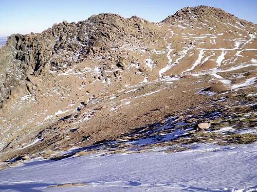
This peak may lack an official USGS-recognized name and not even be ranked per the 300-feet of prominence rule, but it sure offers fantastic views from its rocky summit. Nicknamed “Little Pikes,” (or sometimes “Little Pike,” without the “s”) this rocky jumble of Pikes Peak granite rises over 13,000 feet into the sky northwest of Pikes Peak. Over the dramatic terrain to the east the Rocky Mountains sooth themselves into the Great Plains while to the west the mountain and valley views roll on forever. The bulky mass of Fourteener Pikes Peak rises to the southeast, while Pikes Peak Highway traffic hums along, tourists’ engines straining up steep grades in the thin air. Prayer flags strung at the summit between massive blocks of granite flutter in the breeze.
Whether visited as a side trip to/from the Pikes Peak summit or as a
destination of its own, a visit to the top of “Little Pikes” will give you a place to call your own for a while as you savor views of the surrounding terrain.
Colorado Rank: Unranked
Prominence: 233 feet
USGS Quad: Pikes Peak
Recreation Maps: Several options, including Trails Illustrated #137 Pikes Peak / Cañon City, the Pikes Peak Atlas or the Sky Terrain Colorado Springs and Pikes Peak Map.
Rank & Prominence Info: Lists of John
Getting There
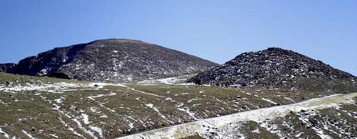
Pikes Peak and "Little Pikes"

Pikes Peak from "Little Pikes"

The "Little Pikes" Summit
“Little Pikes” sits in far northwestern El Paso County, just to the southeast of the corner border with Teller County. Primary access roads are the Pikes Peak Toll Road (for those wanting to drive most the way to the summit), Hwy 67 to the west and Hwy 24 to both the north and east.
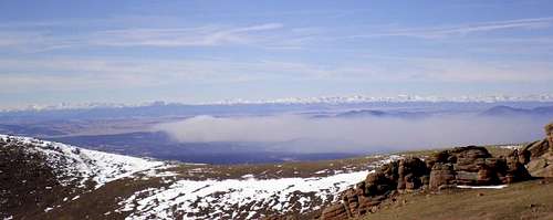
Fire to the west
Red Tape

Granite Boulders

West from the summit
If accessing “Little Pikes” on foot via a hiking approach, there are no fees to access the area. The biggest red tape to be aware of is to ensure you do NOT walk along the Pikes Peak Toll Road and cross only in designated crossing zones.
For those driving up the Pikes Peak Toll Way, usage fees and curfews apply.
•Curfew: Generally speaking, the gates at the tollbooth close at 7:00 PM in the summer and 5:00 PM in the winter. Check the Pikes Peak Highway Website or call 719-385-Peak to check when the gates will be closed for the day you plan to visit.
•Fees: As of this writing, the fee for the Toll Road is $10.00 per adult (16 and over $5.00 per child (6 - 15) or total $35.00 per car. Cash and credit cards (Visa and Master Card) are accepted.
Camping & Lodging

Northeast from the summit

Northeast from the summit

North from the summit

Long winter shadow

The Pikes Peak Highway below
NEARBY NATIONAL FOREST CAMPING
The National Forest Service’s Crags Campground sits on the western slope of Pikes Peak and provides a convenient campsite option for anyone visiting “Little Pikes” from west. This 17-site campground sits at 10,100 feet in elevation about 8 miles south of Divide.
OTHER NATIONAL FOREST CAMPING
The National Forest Service operates three general-use campgrounds in its Manitou Park Recreation Area. The Manitou Park Recreation Area is located about 5 miles north of Woodland Park along Hwy 67. Below is information about these campgrounds as provided by the Forest Service.
•South Meadows Campground: Site has 64 camp sites with parking areas up to 30' long within the 8,000' elevation. Camping season is year round with a user fee of $15.00/per night/per site. The camp-ground has paved roads. Limited sites are reserved by calling 1-877-444-6777. Reservations may be made 240 days prior to arrival and there is a reservation fee. There is also a 2-night minimum stay if your reservation is for Friday or Saturday nights.
•Colorado Campground: Site has 81 campsites with parking areas up to 30' long within the 7800' elevation. Camping season usually begins late May and runs until early September. The user fee is $15.00 per night/per site. This campground has paved roads. Limited site reservations can be made 240 days prior to arrival by calling 1-877-444-6777. There is a reservation fee. There is also a 2-night minimum stay if your reservations are for Friday or Saturday night.
•Painted Rocks Campground: This camping area has 18 campsites with parking areas up to 30' long within the 7800' elevation. Camping season usually begins in May and runs through early September. A user fee of $13.00 per night/per site is charged. Limited sites are reserved by calling 1-877-444-6777 and can be made 240 days prior to arrival. There is a reservation fee.
HOTELS AND LODGING
Those wanting to stay in a hotel and eat at a sit-down restaurant can find ample options in nearby Woodland Park. A few simple hotels (many family-run) are available in Woodland Park (elevation 8,465 feet) along with several RV sites and cabins. For more information visit The Greater Woodland Park Chamber of Commerce Visitor Information page.
Those planning to ascend “Little Pikes” via the “4 tires and a steering wheel” route can find a broad range of lodging options in Colorado Springs and Manitou Springs. If you are the 5-star luxury type, be sure to check out The Broadmoor.
Weather & Seasons
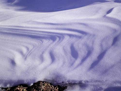
Dramatic snow sculpting
”Little Pikes” is essentially a sub-summit Pikes Peak. As Pikes in the largest landmass for miles around, it is known for somewhat volatile weather. “Sunny and warm with a gentle breeze” in Colorado Springs does not always translate to the same conditions at 13,000 feet on the western slope of Pikes Peak. Check the forecast before departing for your trip and constantly take a read on the weather, noting changes and patterns.
•Summer all but guarantees dense crowds and the dreaded afternoon thunderstorm. Start your day early and anticipate sharing the mountain with plenty of folks.
•Fall means shorter days, but also less afternoon thunderstorm threat. The aspen on the lower reaches of the mountain will delight, as will the orange-tinged alpine tundra. This is the high country, however, so be alert to rapidly changing weather and snowfall, even when the weather in Colorado Springs is quite pleasant.
•Though the western slope is known by many as the “snow route” on Pikes Peak, never underestimate the capability of the flaky Colorado powder pack to hold avalanche danger. Travel during Winter and Spring, when snow is present, should be undertaken with caution. Note that on the Pikes Peak Massif, “west-facing” does not always translate into “windblown / free from loading.” In fact, the western slopes of neighboring Almagre Mountain and South Almagre regularly build up pillows of wind-loaded drifts on their western aspects just waiting for the right trigger to slide.