
-
 9002 Hits
-
 84.82% Score
-
 19 Votes
|
|
Mountain/Rock |
|---|---|
|
|
46.05578°N / 12.28216°E |
|
|
Hiking, Skiing |
|
|
Spring, Summer, Fall, Winter |
|
|
5784 ft / 1763 m |
|
|
Overview
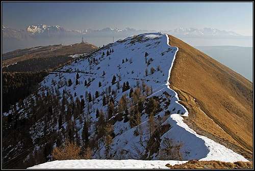 The NE ridge of Col Visentin
 Morning on the ridge
 From the SW
South of Belluno, between the knee of Piave river and the lake of Santa Croce and the town of Vittorio Veneto a stretch of lower mountains is rising (also: Prealpi Bellunesi). On the SW the highest point is Monte Cesen, on the NE there is Col Visentin, the overall highest point in the stretch. More towards the NE and later towards the N the ridge is lowering down towards Ponte Nelle Alpi.
On top all these mountains are grassy, hosting several alpine meadows. Lower sections are forrested. The SE slopes of Col Visentin are more barren, very steep and also rocky. The NW side of the ridge is soon covered with nice forrests.
Unfortunately Col Visentin is one of those mountains where the nature is heavilly degraded. Due to its outposted position the summit is hosting all kinds of telecommunication devices. And because the area is still very interesting for outdoor activities, just on top of the mountain there's also a mountain hut. A broad and well maintained mountain road reaches the very summit.
So, why then going on Col Visentin? First of all, you don't need to drive just on top of it. With a pleasant hike along the main ridge you will gain an immense panorama. Actually, hiking trails are many. A well marked hike goes just along the whole ridge. The trail is a part of the famous Munich - Venice long distance hike. And then there are many others - by roads, by shepherds trails, actually except over the steep SE slopes you can hike anywhere. The road which reaches the main summit from the SW continues along the main ridge. It may not be appropriate for cars, but certainly enables great mountain bike tours. If you think that Vittorio Veneto is as low as 200 meters, then on the ascent on top you must overcome more than 1550 meters of altitude. And you have a possibility of doing a round tour. North of Col Visentin, above Belluno, there is on the altitude of 1000 meters a tourist center, called Nevegal. On the plateau there are huts and hotels and towards the main ridge a cable car goes, serving joy on ski terrains. From the very summit of Col Visentin you can do a nice ski tour towards the ordinary slopes of Piano Nevegal.
Summit Panorama
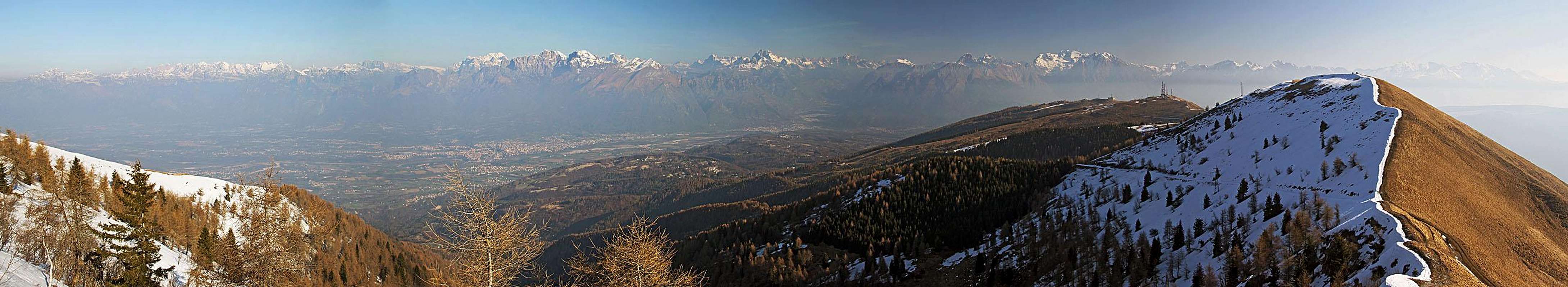
The view from the summit is really a nice one. The most exciting are towards the North Dolomiti Bellunesi and behind them all other Dolomites. More towards the East there are Dolomites d'Oltre Piave and other high summits of Carnic Alps. The southern stretches of Carnic Alps - the groups of Col Nudo and Monte Cavallo are also close and very nicely seen. Across Vittorio Veneto there is the low Monte Pizzoc and then the broad flatland around Venice. Towards the SW we can see other summits of Prealpi Venete e Trentine.
 Dolomites Dolomites |
 Belluno and Schiara Belluno and Schiara |
 Towards the NE Towards the NE |
Getting There
 Mountain road - just below the summit
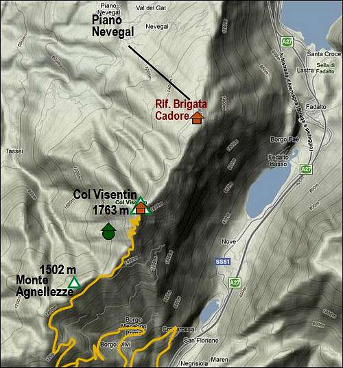
You can most easilly reach the summit of Col Visentin by the mountain road which starts on the northern end of Vittorio Veneto. Soon after the plate denoting start of the town you deter westwards, drive below the highway and the railroad and immediately (by the church) deter right (northward) on a narrow mountain road. It goes through a few small villages and higher by the last hamlets, branches several times so you must be careful to follow the plates (which are not allways there) directing you towards the hut on Col Visentin. Higher the road becomes easier to follow and even broader, but winds a lot, before it gains the main ridge. From the valley to the summit there are some 18 kilometers.
The second starting point is Piano Nevegal. You reach it from the southern outskirts of Belluno. Finally, you could use also several trailheads on the mountain roads which reach west of the main summit, or even start the tour deep below in main valleys.
Red Tape
 Civilization
No restrictions.
Mountain Huts
Just on top of Col Visentin there is Rifugio V Artiglieria Alpina or Rifugio Col Visentin.
visentin - Apr 15, 2011 7:40 am - Voted 10/10
p.s:looks like there is some issue with the page width. And can I attach my pics to your page ? (just views from Vittorio Veneto)
Vid Pogachnik - Apr 15, 2011 10:02 am - Hasn't voted
Re: p.s:I thouht I had attached already all pictures. Sorry for missing them. Of course you can attach them. Regarding the width of page - I see it fine. I don't know. Cheers! Vid