
-
 23976 Hits
-
 87.76% Score
-
 25 Votes
|
|
Mountain/Rock |
|---|---|
|
|
50.59490°N / 115.403°W |
|
|
Mountaineering |
|
|
Spring |
|
|
11227 ft / 3422 m |
|
|
Overview
Mount King George is an attractive and remote peak located in the southern Canadian Rockies. It is one of four peaks between the 49th parallel (US border) and the southern boundary of Banff National Park that exceed 11,000 feet (3353 metres). The other three mountains being Mt. Sir Douglas (on southern Banff park boundary), Mt. Joffre and Mt. Harrison.Mount King George is located west of the continental divide, entirely within the province of British Columbia. The high elevation of Mount King George makes it very prominent from many surrounding lower summits. For many climbers from the Calgary/Canmore area who frequent summits in the Kananaskis region, the spectacular glaciated East Face of Mount King George is a familiar sight; sort of like an old friend.
Mt. King George is part of the Royal Group, a small range of peaks named for members of the reigning British royal family at the time of naming (King George V ruled the British Empire from 1910 to 1936, range named in 1913). Mt. King George is located in the relatively new Provincial Park, Height of the Rockies Provincial Park, which was created in 1995. The mountain is relatively remote since it is not accessible by a paved road. The road access is only by local logging and mining roads, which appears to be complicated and unpredictable, but is actually quite straightforward. There is no designated or maintained trail system to access the mountain, and a local storied history of thick bush and impassable rivers makes many mountaineers shy away from this impressive peak.
 East Face of Mt. King George East Face of Mt. King George |
 King George Glacier King George Glacier |
|---|
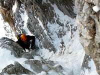
If Mount King George were more easily accessible it would certainly have more climbing routes and be summited more often, but the remoteness of this peak provides a true wilderness experience. Mount King George is one the 11,000’ers of the Canadian Rockies (31th highest of the 54 peaks) and sees attention from peak baggers. The high quality of snow/ice routes make this peak worth a visit regardless of the elevation. Significant glaciers line the south and eastern slopes and valleys of the peak, with access to most routes from the larger eastern glacier.
Getting There
The parking area for Mount King George is relatively easy to access by vehicle, but the approach on foot can be complicated and difficult.A local author and climber, Bill Corbett, has a great guidebook, “The 11,000’ers of the Canadian Rockies” which details excellent driving directions. I attempted King George in 2005, but couldn’t access the South-East Ridge from the King George Glacier because of a raging waterfall in the access chimney; instead we climbed nearby Mt. Prince Albert, which was a great peak in itself. In 2008, I climbed the East Face of King George via the Congdon/McNab route and both times the information provided for driving directions were prefect. I would recommend referring to this guide for driving instructions.
Simple driving directions would be: from Highway 93 in southern Kootenay National Park take Settlers Road (93/Settlers Road intersection is 84 kilometres south from Trans Canada Highway at Castle Junction in Banff National Park, or 20 kilometres north of Radium, British Columbia) to the Palliser River logging road. Approximately one hour and 60 kilometres from Settlers Road turnoff park near the confluence of Fynn Creek and Palliser River. Approximate road parking spot at NTS map grid reference location 82J/11 (185992). (NTS is the Canadian Government National Topographic System map series, they are excellent maps).
In 2005 and in 2008 the primitive log bridge over the raging Palliser River was in great shape. In June of 2013 massive flooding occurred in the southern Rockies. Friends of mine ascended Mt. King George in 2014 and this great backcountry bridge was gone. A strategic tree was felled over the river, in a similar location (easily accessed from the standard parking area), but missing the security of foot rungs and wire handrail. This new log provides an exciting and challenging crossing of the Palliser River, but much better than a swim.
 Bridge over Palliser River 2008 Bridge over Palliser River 2008 |
 Bridge over Palliser River 2014 Bridge over Palliser River 2014 |
|---|
Numerous horse trails exist along the Palliser River, Fynn Creek and the access to the Queen Mary Lake hut. These trails vary in quality and reliable in direction of travel. A web of meandering trails can make access to the King George Glacier confusing and getting lost in lower Fynn Creek is common.
Best chance of not getting lost is to follow the circuitous surveyor flagging tape marked trail. The trail was well marked with tape in September 2008, but trail conditions and flagging had likely changed since this time. The first section of the trail is easy to follow along the Palliser River, but heading north up Fynn Creek, things get dicey. Good luck, again I recommend Corbett’s book for help, but generally follow your spider senses.
Above tree line head towards the south side of Mt. Princess Mary, if ascending the South Glacier better to head west into the west head of Fynn Creek, all other routes are usually accessed from the east head of Fynn Creek with a camp near the toe of the King George Glacier. Great campsites around NTS grid 82J/11 (150035).
 Bivy campsite at tree line
Red Tape
Height of the Rockies Provincial Park is part of the British Columbia Provincial Park System and no permits or passes are required for climbing, parking or camping in this park. Height of the Rockies Provincial Park is a wilderness area, without supplies or equipment of any kind. The park contains high concentrations of elk, mule deer, bighorn sheep, moose, cougar, black and grizzly bears. Be aware of wildlife and practice “Leave No Trace” ethics.Up to date information about Height of the Rockies Provincial Park available at:
www.env.gov.bc.ca/bcparks/explore/parkpgs/height
Camping
Height of the Rockies Provincial Park is a wilderness area, without any designated campsites in the Mt. King George area. Typical bivy site for most routes are from a camp near the toe of the King George Glacier. Great campsites exist around NTS grid 82J/11 (150035).When to Climb
Typical Canadian Rockies situation with July and August providing the best conditions for high elevation climbing. Often September and October have stable and dry weather, but conditions can change dramatically. Fall climbing does provide colder temperatures for snow climbing, but with less snow for climbing and bridging of crevasses.The complicated road access is not maintained or plowed in the winter and would make a winter (or early spring) ascent an epic adventure. There is no record of a winter ascent.
Route Descriptions
Six climbing routes have been documented on Mount King George. The relatively easy South, South-West and South-East slopes do provide a range of options and several variations are possible. The massive and spectacular East/North-East Face could provide opportunity for more modern and difficult climbing routes. Documented routes include: East Face of Mt. King George with routes marked
- South East Ridge, Alpine II, 5.3
Route for the second ascent of Mt. King George in 1970 by Gerry Brown, John Carter and William Hurst of the Kootenay Mountaineering Club. Access from the east head of Fynn Creek with a camp near the toe of the King George Glacier. Gain glacier and head towards King George/Princess Mary col. Easy access to col is blocked by a near vertical headwall, gain col by the southern of two obvious rock chimneys/gullies. (Note: often in early summer these gullies can be waterfalls making ascent difficult or impossible.)
Just below main col traverse right (north) up a small snow/scree gully to reach the broad South East ridge. Follow increasing narrow ridge (5.3 sections). (route 1 on photo)
Before ridge ends traverse west, across glacier, and cross a bergschrund towards a deep notch (top of Congdon/McNab couloir). Ice and snow up to 35 degrees on traverse. Follow snow, ice and/or scree slopes (depending of time year) of upper South West face to summit ridge and on to summit. Return the same way, or descend to south glacier then south of Mt. Princess Mary back to bivy.
- East Face/North Ridge, Alpine II
Line of the first ascent of Mount King George in 1919 by Val Fynn and guide Rudolph Aemmer. (route 4 on photo) Gain King George Glacier, head north along glacier to get above looming hanging glacier on East Face. Once past hanging serac wall, cross bergschrund to gain steep ice above, leading to a firm, but steep rock rib, just north of the hanging glacier on East Face. The upper section of the rib is brittle with an ice ridge leading to the North Ridge. Take ridge to summit with snow, ice and rock sections.
 Upper East Face and North Ridge of Mt. King George
- East Face, Alpine III, 5.3
First Ascent of route: September 2, 1984. Frank Campbell, Russ Varnam and Karl Nagy.
Moderate route, mostly on snow/ice with class 4 mixed climbing and easy 5 class climbing on the ridge above the final ice slopes. (route 3 on photo) Descend South East Ridge route or descend South Glacier then south of Mt. Princess Mary back to bivy.
Quote from Canadian Alpine Journal article, Volume 68, 1985.
“We decided to try an appealing line about 200 metres to the right of the Congdon/McNab couloir. The climb itself is relatively straightforward, mainly an ice route with class 4 mixed rock below and easy class 5 mixed climbing on the ridge above the ice, all with crampons. Once across the first ‘schrund four pitches of enjoyable mixed class 4 rock was climbed to the base of the obvious hanging glacier in the middle of the face. In some years, there may be greater serac and cornice fall over the lower pitches.
The hanging glacier was climbed direct from the bottom with two pitches of stepped, steep to vertical ice (grade 3), to a snow slope below a huge intimidating 40 ft high, 400 ft wide overhanging ice barrier. We traversed right and up to the base of the upper face. Another schrund and about 500 ft of typical 45 degree alpine ice brought us to join up with the Fynn first ascent route below the summit.” Karl Nagy
- South West Face/West Ridge, Alpine II
Route for the third ascent of Mt. King George in 1970 by D. Hurrell and R. Mill. Access from the east head of Fynn Creek with a camp near the toe of the King George Glacier. Gain glacier and head towards King George/Princess Mary col. Easy access to col is blocked by a near vertical headwall, gain col by the southern of two obvious rock chimneys/gullies. (Note: often in early summer these gullies can be waterfalls making ascent difficult or impossible.)
 Gullies to gain King George/Princess Mary Col
Climb ice and rock to gain West Ridge, Follow ridge for 200 metres then climb diagonally to gain upper South West Face to summit ridge and on to summit. Return the same way, or descend to south glacier then south of Mt. Princess Mary back to bivy.
- Congdon/McNab Couloir (East Face), Alpine III
First Ascent of route: October 1, 1980. Dwayne Congdon and Dave McNab.
Couloir very obvious from summits to the east; long, steep, direct route from King George Glacier to a prominent notch in the South East Ridge. (route 2 on photo) Usually the route is all snow and ice, but couloir has short step (5 to 8 metres) near the top that could melt out.
Once on the South East Ridge follow snow, ice and/or scree slopes (depending of time year) of upper South West Face to summit ridge and on to summit. Descend South East Ridge route or descend South Glacier then south of Mt. Princess Mary back to bivy.
 Base of Congdon/McNab couloir
Quote from Canadian Alpine Journal article, Volume 64, 1981.
“On October 1, 1980 Dave McNab and I climbed Mt. King George's east face via its central couloir. This 1200 ft route splits the face in half. Technically the route is moderate. The overall angle of ice is 45 to 60 degrees with two short 70 degree sections. Only one pitch was belayed.” Dwayne Congdon
- Elzinga/Welsted Route, Alpine IV, 5.6, M4R, WI 3+
First Ascent of route: September 15, 2012. Jim Elzinga and Ian Welsted.
Exciting new route on the East/North-East Face of Mt. King George. First ascentist Ian Welsted provided this description. Ian and Jim are local hard core alpinists, great to the see new development on this spectacular face.
Gain King George Glacier, head north along glacier aiming to stay left of the hanging glacier higher up on the face. Start on the North-East face as for the East Face route (Campbell, Varnam, Nagy 1984). Choose the right most gully, if you are below seracs you have gone too far. Begin up either rock to either side of gully or up ice in gully depending on temperature and state of ice. When we did the FA on Sept. 15th there was no ice on this lower part of the route, although there has been on previous attempts. Traverse into the snow gully. Continue up the snow gully with occasional easy ice steps to a band of mixed climbing. Climb one 60 meter pitch of M4R mixed rock with scant pro to where it steepens into an overhang barring the way. In colder conditions an ice pillar has been formed to be climbed directly at this point. Lacking the pillar traverse 5 meters left to another gully system. At about 30 meters step up and right into a narrower constricted gully. At 60 meters belay at the top of this constricted gully where it widens. Romp up this snow gully with ice steps toward the last technical pitch, a WI3+ pitch in a large corner which brings one to within a few rope lengths of snow from the summit ridge. Descent: via the normal route as far as the Queen Mary/King George col, then a couple of raps to the glacier. Ian Welsted

|
 |
 |
 |
|---|