
|
|
Mountain/Rock |
|---|---|
|
|
37.15520°N / 113.8825°W |
|
|
Washington |
|
|
Hiking |
|
|
Spring, Summer, Fall, Winter |
|
|
7680 ft / 2341 m |
|
|
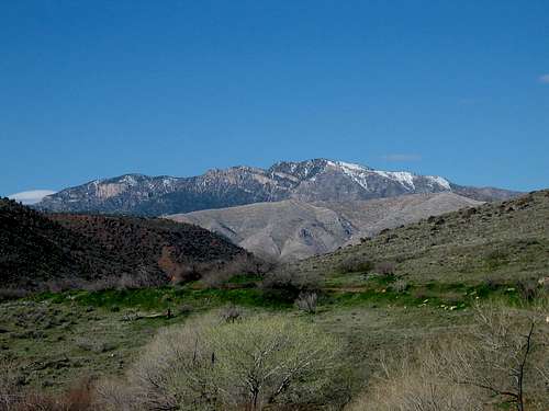
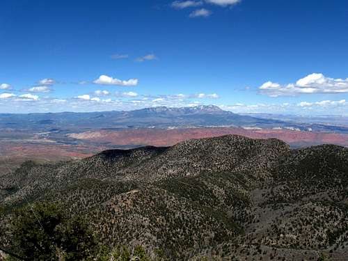
The view from the top
Overview
West Mountain Peak is located near St. George Utah and makes a good "something" to do if you find yourself with time to play with or combinedwith a visit to Zion National Park for a change of pace. Having 3660' of
prominence makes this the 24th most prominent peak in the state of Utah and thus an interesting peak to the group of hiker/climbers who are out there chasing these peaks.
It has a terrific view from its summit and it is both cursed and blessed by its own special dominance of the local terrain. The curse? When man needs a place to put up communication antennas/towers/structures, a mountain top like this one becomes prime property and as a result the top of this mountain, the highest in the Beaver Dam mountain range, bristles with lots of stuff. A road amazingly snakes its way to the top but it is a road that most people will not or cannot drive. High clearance 4WD vehicles are necessary to make the drive up the last mile and some tight turns make this one a white knuckler if you choose to attempt it. I have both walked and driven this one on two visits to the summit and will cover both visits in the "getting there" section below. Blessed? The view. Those two words say it all. This place is an incredible viewpoint and as mentioned in the first part of this paragraph, the view is terrific.
Now the natural tendency of people is to discount a mountain when they find out it has an antenna, or a lookout or anything man made on its summit. Some like Pikes Peak or Mount Washingtonn are horribly disfigured by man made structures. I maintain that this isn't the fault of the mountain. There are always other ways to a summit besides a road that you could drive. How about walking the road or finding another way up. Pikes Peak has trails as does Mount Washington so you can still experience a certain feel of the mountain on its own terms but in the case of West Mountain Peak, I know of no trail so the road becomes basically the choice one has to get to the summit.
Getting There
From St. George Utah, take the old highway 8 that used to be the main road before the I-15 section through Virgin Canyon Gorge was built. Highway 8 will take you through Santa Clara and then the Shivrits Indian reservation. After the reservation, watch for the reservation boundary sign at about 6 miles from the reservation townsite because the turn off for the unmarked Hell Hole pass road is one mile beyond it. (37.1306 113.8028 nad 27)
Turn right onto the road and drive up the gravel dirt road another 4+ miles to Hell Hole Pass (6250') and take the road to the right at the top of the pass. The first sign I saw noted that it was 2 miles from the pass to the towers. The road to the left heads to Indian Springs. Taking the right fork at the pass, this road descends a bit, and you will see the communication towers that adorn the top of West Mountain Peak. I initially drove to where this road stops its descent and parked off to the side of the road and walked it from there. If you are intent on driving to the top then continue on and test your driving skills and later on, downshift to your lowest gears and try not to have to rely on your brakes. The last bit gains over 900 feet to the top in just about a mile but some parts are steep and you might want to have your 4WD in its lowest gearing. Walking it isn't a bad choice.
On my first visit on May 24, 2008, I parked close to 2 miles away and walked the road to the top, similar to what Scott Surgent did. Overall, I believe I gained close to 2000 feet (counting both ways)and it was a good way to get a workout in. On my second visit, on April 30, 2011, I elected to drive to the top since Dennis Poulin and I had just done a six mile hike with about 2500' of elevation gain on Scrub BM peak. Having done it as a hike and also as a drive, my preference would be to make a hike out of it.
Red Tape
None that I am aware of.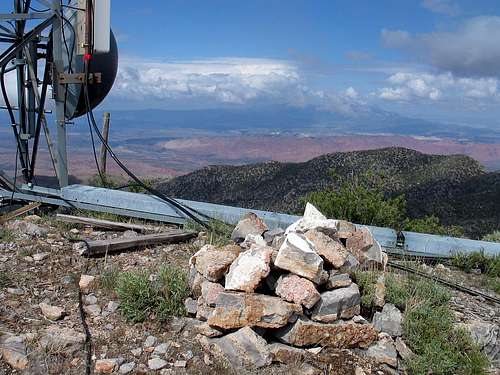
Summit cairn

Summit BM
Camping
You are close enough to St. George that accomodations are found easily but for those who want to camp, Gunsight reservoir has some nice possibilities. See Eric Willhite's report on Gunslock reservoir HERE.You could also camp off the road in a few places on the drive in as noted by some old campfire rings seen off to the side of the road. Please make as small an impact as possible and haul out your garbage.
External Links
Scott Surgent's TREric Willhite's TR
Shivwit Indian reservation
Jacob Hamblin home in Santa Clara
St. George weather
St. George weather linkPics
Pics by Scott Surgent (used with his permission)When Scott decided to hike from Hell Hole Pass to the summit, he provided inspiration to follow his example. Here are a few of his pics that he took
on his hike on a very hot day. See all of his trip report:
Here
 Road & Structures
 |  Summit ahead
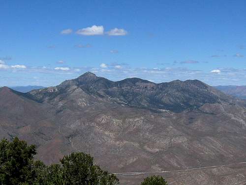
 |  Looking south
 |