
-
 13400 Hits
-
 69.75% Score
-
 2 Votes
|
|
Mountain/Rock |
|---|---|
|
|
27.96533°N / 86.33512°E |
|
|
Mountaineering |
|
|
Spring, Summer, Fall, Winter |
|
|
23406 ft / 7134 m |
|
|
Disclosure Statement
Though some of the information on the page is not first-hand (it is an extremely difficult and expensive mountain to climb), it comes from research done in Nepal and on the Internet - research that took some time to conduct. It is not meant to guide climbers of the peak per say, but provide general information on an unique, obscure mountain. With hardly any information available on this seldom-climbed mountain, this page serves as a modest compilation of knowledge to make available to those curious about the high peaks of the world. In the spirit of sharing information with the mountain-loving community at large, I created this. If you have beta as well, please feel free to contribute because that is the original purpose of SP - to share the wonders of the mountains with each other. Thanks!Overview
About mid-way between Kathmandu and Everest as the crow flies, this sacred mountain is frequently mistaken for Everest when seen from the Kathmandu Valley. It rises 5,684 meters (18,648 feet) above the junction of two valleys, the Rolwaling Chu (to the south) and Bhote Kosi (to the west). Dominating the view to the north from Charikot on the way to Jiri (the start of the Everest basecamp trek) with its sister peak Melingtse (7,181 meters), Gaurishankar reigns over the Rolwaling region.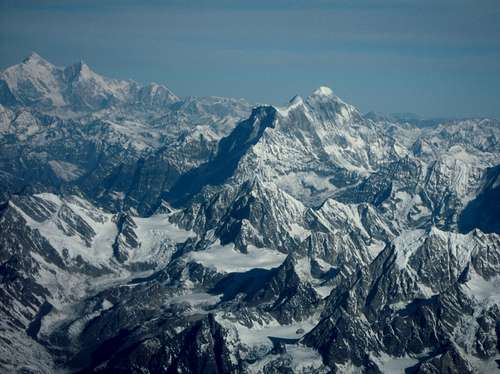
Gaurishankar and the Rolwaling with Shishapangma on the horizon. March 2011.
Getting There
Nepal side:From Kathmandu, travel east to the small city of Charikot, which is on the way to Jiri. It takes about 5 hours or so by bus. From the main intersection in Charikot, a road rolls north past Dolakha a couple hours to the bottom of the valley, which serves as the starting point for the Rolwaling trek.
Tibetan side:
???
If you have any info, please contribute.
Red Tape
Mountaineering:Gaurishankar is a serious undertaking requiring nothing less than an expedition of some tough mountaineers. Check out the Nepal Mountaineering Association website. The general climbing rules apply to the trekking peaks like Mera Peak and Cholatse, but it is unclear whether there is a separate set of regulations for Gaurishankar. Anyway, the website has the application at the bottom of this page on the site.
Trekking:
Due to the isolation, difficulty, and lack of 8000-meter peaks, many tourists do not frequent the challenging Rolwaling trek near Dolakha. It follows the Rolwaling Chu, an east-west valley below Gaurishankar that travels into the heart of the Rolwaling Range just south of the Tibetan border to Tashi Lakpa Pass (5755m) that serves as the gateway between the Rolwaling and Khumbu. The trek boasts a significant biodiversity and several small Tamang settlements with amazing views of many 6000-meter peaks. Rumored to be the home of the Yeti, researchers have tried and failed to find the beast in this region. Beding has one of the highest concentrations of Everest-summiteers in the world with several teenagers who have succeeded.
Best seasons: February-May, October-November
Duration: 18-21 days
Maximum Elevation: 5755 meters/18,881 feet (Tashi Lakpa Pass)
Camping
There are huts with low-priced beds, and designated camping areas along the trekking route into the Rolwaling towards Beding.Climbing History
Few have reached the north summit due to regulations and climbing difficulty.First Attempt – 1954
1965-1979 – closed to climbing
First Ascent – John Roskelley and Dorje Sherpa – May 8, 1979
As of 2011 based on the Himalayan Index, there have been only 3 successful attempts.
A handful of expeditions have been mounted. Below are links to a few descriptions.
2009 - NE Face
2009 - SW Face
2013 - French Route South Face