
|
|
Mountain/Rock |
|---|---|
|
|
39.01509°N / 119.88481°W |
|
|
Douglas |
|
|
Hiking |
|
|
Spring, Summer, Fall, Winter |
|
|
8901 ft / 2713 m |
|
|
Overview
Peak 8901 is a craggy ridge located in the mountains directly east of Lake Tahoe within the Carson Range. It has a prominence of over 450’ and shares a saddle with nearby Genoa Peak 9,150’.
It is accessible from the Kingsbury Grade North trailhead via Genoa Peak Road. Because it is located on the east side of Lake Tahoe, it typically gets much less precipitation than its neighbors on the west side of lake. To reach the summit requires approximately 2 ¼ miles and 1150’ of elevation gain from Kingsbury Grade. It also makes a good combination hike with Genoa Peak, located about 2 miles to the north.
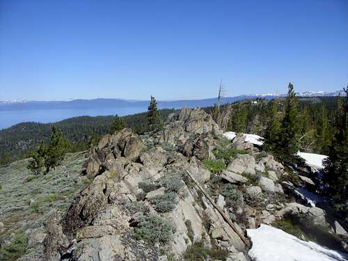 Craggy summit rocks atop Peak 8901 - with Lake Tahoe below
Views from the summit are exquisite. Lake Tahoe and the Desolation Wilderness to the west, the Pine Nuts and other desert peaks to the east, and the Sierra Nevada to the South. Overall, an incredible view.
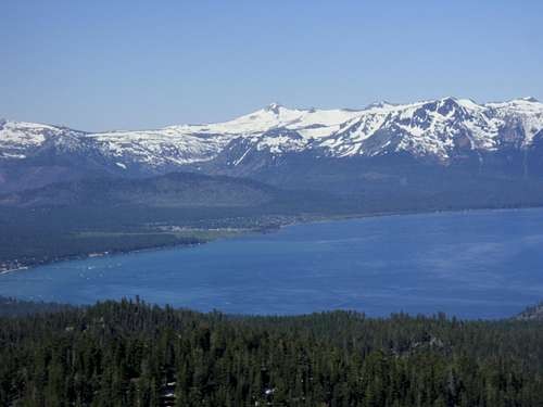 View of Pyramid Peak 9983' and the Desolation Wilderness, with Lake Tahoe below.
The mountain can be hiked during most of the year, and is a good place to snowshoe in winter. The best months to hike without snow are between June and November. However, the best time of year to hike is probably in October when fall colors are out or in June when the snow begins significant melting, but temperatures are still moderate. In July and August temperatures in this part of the Carson Range can reach well into the 80s.
A plane crashed just a few hundred feet below the summit on March 1, 1964. There is a memorial and some wreckage still visible on a dirt road west of the summit.
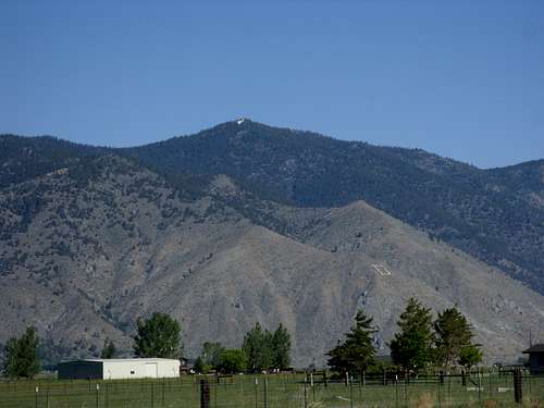 Peak 8901 seen from the Carson Valley.
Getting There
From Carson City, continue south past the US Highway 50 West junction for about 1.3 miles to NV-206 South (Jacks Valley Road). Continue as it heads towards the foothills just below Genoa Peak to the small historic community of Genoa, Nevada. Continue through Genoa (slow down to avoid the speed trap) and continue on for another 5 ½ miles to the entrance to NV-207 – the Kingsbury Grade Road, which heads uphill over the Daggett Pass 7334’ (about 8 miles from the junction with NV 206). A little less than ½ mile past Daggett Pass, take a right onto North Benjamin Drive and continue up the road as it turns into Andria Drive, which turns into Genoa Peak Road. From the turn off from NV-207 onto North Benjamin Drive, it is about 2 miles to the Tahoe Rim trailhead at 7780 feet. Park near the trailhead and continue up to Genoa Peak Road.
Route Information
The primary, and shortest, route is via Genoa Peak Road. The Tahoe Rim Trail does not head in the direction of Peak 8901. Take Genoa Peak Road for about 1 ¼ miles. A road veers off on the right and heads up towards Peak 8901. Follow this road for about ½ mile, and another road veers right. Take this road until it dead ends at a memorial sign after about ¼ mile. From here, you have to walk up the brush for about 300 yards up about 260’ to the craggy summit. It isn’t clear where the actual high point is located, but there are a couple rocky areas on the south side of the ridge that appear to be the highest point. The one furthest south is the actual high point, but it does not have a USGS marker.
To reach Genoa Peak, head back down the slope and find the road where you took the initial right turn. This heads up to another overlook in a little less than a mile, and then back down towards a road heading up to Genoa Peak in a little less than ¾ miles. From the base of the road, it is about 750’ in 2/3rds of a mile to the summit of Genoa Peak. Return to the trailhead via Genoa Peak Road for a round trip hike of about 8 miles.
Red Tape
There is no red tape. Parking is free and the land is publicly managed by the U.S. Forest Service.
There are no permits needed to hike on the Tahoe Rim Trail or any fee to park at the trailhead. When the pass gets heavy snows, roads may be closed. Roads may also be closed during the summer due to fire danger.
During the summer, bikers are frequent on the Tahoe Rim Trail. While some sections of the TRT are closed to mountain biking entirely or on certain days, mountain biking is permitted on this entire section of trail between Spooner Summit and Kingsbury Grade. Biking is allowed on Genoa Peak Road.
External Links
Tahoe Rim Trail maps and information for Spooner Summit to Kingsbury Grade North