
|
|
Mountain/Rock |
|---|---|
|
|
47.54729°N / 121.64196°W |
|
|
King |
|
|
Hiking |
|
|
Spring, Summer, Fall, Winter |
|
|
4965 ft / 1513 m |
|
|
Overview
 Summit!
Summit Elevation: 4965 feet
Round Trip Distance: 13.2 miles
Elevation Gain: 4343 feet
Elevation Loss: 311 feet
Moolock Mountain is the highest point along the ridge running from Green Mountain to South Bessemer Mountain. It holds 925 feet of prominence from the next highest peak, South Bessemer Mountain 1.3 miles to the east. Moolock Mountain also ranks #96 on the "Home Court 100" and despite a long hike, offers great views. If a DNR gate key cannot be acquired the hike from the Middle Fork Road is 6.6 miles one way and gains 4,300 feet but only about 1 mile of that is not done on forest service roads.
The name Moolock comes from the Chinook word for "elk" but was the mountain named for a presence of elk, or was it named for being close to the lake of the same name at its flank? Either way, it is quite likely that elk may be present as it is in the proximity of the North Bend/Snoqualmie Pass elk population.
As most of the hike is done along forest service roads it is easy to spot one of the other added benefits of this hike. Wild berries! Salmonberries, Huckleberries, Blueberries, my favorite Thimbleberries and some others I could not identify.
Moolock mountain also lies inside the Mount Si Natural Resources Conservation Area. This is most likely for the presence of the three large lakes to the west of the summit. The boundary is probably on the order of a few hundred feet including the summit. At present all that can be sure is that it is part of the "study area" but very likely it will be included in new maps for the area.
Moolock Mountain Views
The Views are certainly the best reason to hike to Moolock Mountain Lakes to the West
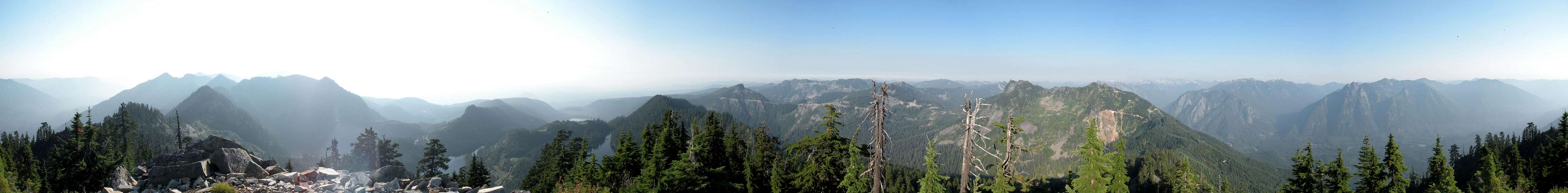  |
Getting There
 Topo of route
At times the route finding can become difficult. Most notable being: 1 at the borrow pit roughly 5.4 miles into the hike. The 4WD road to the right of the pit can become difficult to identify when the brush grows up. 2 venturing off the 4WD road on to the summit ridge. I found that by following the road far past the beginning of the talus, it saved some hassle. 3 once the ridge is attained getting to the summit is a bit of a jumbled mess. From talus to brush and back several times. Stay as near to the ridge as you can for best results.
Red Tape
Several "No unauthorized entry" signs suggest that this is not an area that people should be going. It is State DNR land and you are allowed, these signs are more meant to prohibit motorized uses. A private quarry does exist up this road and heavy trucks may come rolling by.New in 2011 a Discover Pass is required to park at the trailhead. The pass is $10 per day or $30 per year. If caught without the pass the fine is $99 so please keep this in mind.
Redwic - Mar 15, 2012 2:17 pm - Voted 10/10
"Discover Pass" Now RequiredBeginning during 2011, parking areas and trailheads within and for the Mount Si NRCA require a Discover Pass to be in each vehicle during the visit. Failure to have a Discover Pass visible within a parked vehicle at these locations can result in a substantial fine. For more information regarding the Discover Pass, please visit the official website.
Arkitekt - May 29, 2012 9:51 pm - Hasn't voted
Finally added itThank you for the correction. I have not had much time but I have made a note on the page to reflect the new parking restrictions.