
-
 21361 Hits
-
 89.68% Score
-
 30 Votes
|
|
Mountain/Rock |
|---|---|
|
|
61.18893°N / 149.31519°W |
|
|
Scrambling |
|
|
Summer, Fall |
|
|
5994 ft / 1827 m |
|
|
Overview
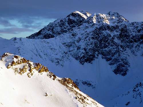
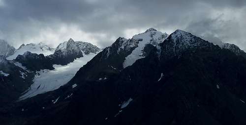
The three summits of Hurdygurdy Mountain -- Point 5764, the main summit, and Point 5500+ -- are arrayed in that order from left to right along the top margin of this November view from a shoulder of Harp Mountain. The fourth summit, behind and to the right, is Eagle Peak.
Sixteen miles from downtown Anchorage, Hurdygurdy Mountain jumps 5600 feet in a single leap from the Eagle River. The few scramblers who visit its summit don't come up that face, though--they generally trek in cross-country from the trailheads on Hiland Road.
Hurdygurdy is comparable in effort, difficulty, height, and view to Cantata Peak, but it lacks that mountain's charismatic appearance and so doesn't get much attention. It does offer a rewarding ridge-top ramble in lonely, spectacular country.
The first recorded ascent of the mountain was in 1969, when Grace Hoeman made a November climb straight up the south face, accompanied by April Allen and Ned Lewis. Hoeman was a physician and one of the pioneer women climbers of Alaska, and an interesting character. This climb came a few months after she lost her beloved husband to an avalanche on Dhaulagiri, and a few months before her "Denali Damsels" climb with Arlene Blum. She died in an avalanche near Eklutna Glacier in 1971.
Getting There
Two trailheads are mentioned in the route descriptions farther down this page. The basic trailhead for one variant of the northwest ridge route, as well as for the south gully route, is the South Fork Valley Trail trailhead. To reach it, take the Eagle River Loop Road exit from the Glenn Highway and then turn right onto Hiland Road. Follow Hiland Road several miles until it crosses a major stream (the South Fork) and runs along the east slope of a broad valley. Here you will see a sign indicating the right turn to the trailhead, which is back across the stream on the west side of the valley.The trailhead for the Harp Mountain variant of the northwest ridge route uses a small trailhead on the east side of the South Fork Eagle River Valley. For this trailhead, continue on Hiland Road to its very end, where there is a turnaround. The trail begins from the turnaround circle, just to the left of 252 Hiland Road. In the last couple of years there has been a little sign by the trail indicating "State Park Access." Do not park in the circle; a proliferation of no parking signs will require you to park a short distance up the road.
Routes
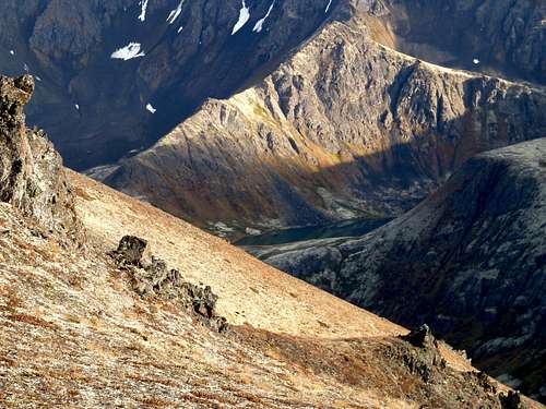
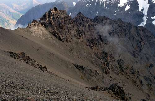
Scenery on the approach to the northwest ridge (Hanging Valley Lake)
Northwest Ridge Route (class 3+): This route ascends the intimidating-looking ridge that connects the Eagle River Overlook plateau to Point 5500+, then continues across Point 5764 to Hurdygurdy.
There are two ways to reach the base of the ridge. The conventional way is to park at the South Fork Eagle River Trailhead and take the trail toward Symphony Lake. After about two miles the trail drops to the river, crosses over a bridge, and ascends benches on the other side. Look for a left fork about half a mile after the bridge, and follow this into "Hanging Valley" (the valley is so labeled on some maps; it is the valley running below the south face of Harp Mountain). Walk up this a couple of miles and then climb grass to the lowest point on the valley's left (north) wall. This is the 3800-foot col on the long ridge that connects Harp Mountain with Hurdygurdy and its neighbors.
A more spectacular way to get to the same place is to park at the end of Hiland Road and take the West Ridge Trail up Harp Mountain, and then continue down the ridge on the opposite side to the 3800-foot col. This is much shorter in terms of mileage, but has much greater elevation gain owing to the traverse of Harp Mountain's 5001-foot summit.
Regardless of which approach you use, it will probably take you three hours or so to get to the 3800-foot col.

Approaching the NW ridge
From the col, walk southeast up broad, tilted tableland to the southern apex of the plateau, where a steep ridge continues to the top of Point 5500+. Take this--it's class 3 with moderate exposure if conditions are dry and your routefinding is dead on. Watch for sheep trails showing you bypasses to climber's left. About 700 feet of scrambling brings you to the top of Point 5500+. Now you've got another hour of easier scrambling across the summit of Point 5764, over some smaller points, and up the final ridge to the top of Hurdygurdy.
It took me a little more than five hours to complete this route using the Harp Mountain traverse approach, and almost as long to return to the car--much of the ridge travel is slow going. Your mileage may vary ...
(As a variant, I have heard of two people who bypassed the steep ridge to Point 5500+ by dropping 400 feet into the bowl to the east, which contains a remnant glacier or ice body. From there, a thousand feet on an unpleasant-looking tongue of steep scree leads to the col between Point 5500+ and Point 5764.)
South Gully (class 3): From South Fork Eagle River Trailhead at 2000 feet elevation, follow the South Fork Valley Trail up the main valley. This trail was reconstructed in 2011 into a virtual highway, and the walking is fast and easy. After 5 miles you reach a large moraine, where you cross the South Fork on a bridge follow a boot track through a boulder field onto the crest of the broad moraine between Eagle and Symphony Lakes. Angle back down to Eagle Lake and make your way along its south shore, and then follow its inlet stream about half a mile farther east (game trails and light bushwhacking, marshy footing). Your first opportunity to climb the north wall of this valley will be a huge, broad gully that runs up to the col between Point 5500+ and Point 5764. There's a waterfall at the bottom of the gully. Use steep grass to the right of the falls to get into the gully proper and trudge up 3000 feet to the ridge; once there, about an hour of class 2 and 3 scrambling along the crest brings you to the top. If using this route in descent, move far to skier's left near the bottom to avoid the cliff bands around the waterfall. The whole route, trailhead to top, is about nine miles one way and takes a bit longer than the northwest ridge route, although it's an easier journey.
Orientation
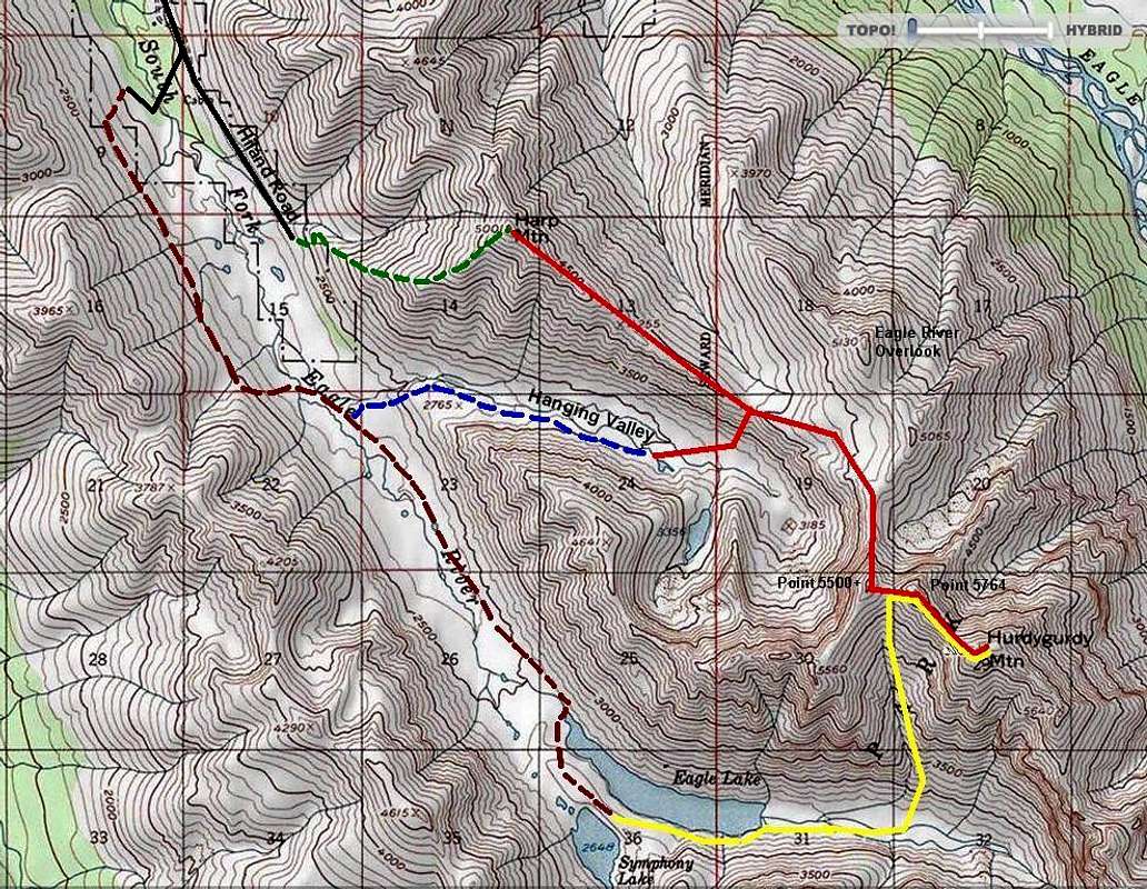
MAP KEY
Green dotted line: Harp Mountain Trail
Brown dotted line: South Fork Eagle River Trail
Blue dotted line: Hanging Valley Trail
Red lines: Northwest ridge route to Hurdygurdy Mtn
Yellow line: South gully route to Hurdygurdy Mtn
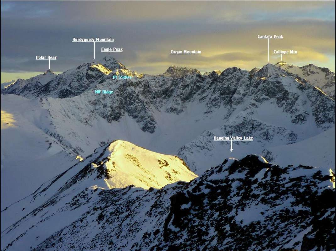
PEAK IDENTIFICATION (FROM HARP MOUNTAIN AREA)
Summit Views
The top of Hurdygurdy puts you among some of Chugach State Park's giants. Flute Peak, Flute Glacier, Calliope Mountain, and Cantata Peak dominate this southward view on a stormy September evening.
 Eastward along the rugged ridge toward Eagle Peak | 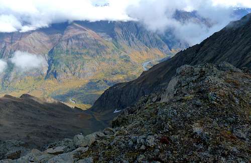 Down the north face toward Eagle River Nature Center a mile below |
Camping
Along the northwest ridge route, there is great camping in Hanging Valley, and you can also camp with access to perennial water at the 3800-foot col. Along the south gulley route, the campsites of choice would be at Eagle and Symphony Lakes, six miles in.Red Tape
Chugach State Park has few restrictions on hiking, camping, and climbing. Campfires are not permitted and very large groups will need a permit.There is a $5 parking fee for the South Fork trailhead, unless you have an annual park pass. In 2022 this fee is being strictly enforced. There is no fee for the Harp Mountain trailhead.
Links
Chugach State Park MapIce climbing routes on lower north face