
|
|
Mountain/Rock |
|---|---|
|
|
34.26160°N / 117.599°W |
|
|
San Bernardino |
|
|
Hiking |
|
|
Spring, Summer, Fall, Winter |
|
|
8985 ft / 2739 m |
|
|
Overview
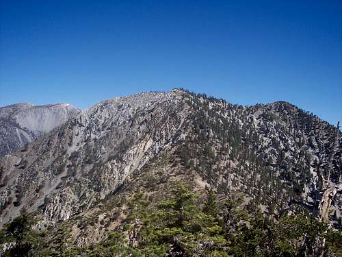
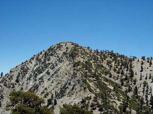
Telegraph Peak is located deep within the Cucamonga Wilderness Area of the eastern San Gabriel Mountains. It is the second and dominant peak of the well known three Tee's, a popular up and down day hike. Its prominence as the highest point in the Cucamonga Wilderness area and rugged ridges make it stand out compared to its gently sloping neighbor peaks and mountains. Telegraph's location offers terrific views of the Lytle Creek Drainage and Cajon Pass to the east with Cucamonga Peak, to the south. However the best views are northwest with Mount Baldy and the bowl, Mount Harwood and Dawson Peak . The traverse from Timber to Telegraph is one of the most scenic sections of the San Gabriel Mountains and gives you a sense of the high country. On clear days a good portion of the San Bernardino San Gorgonio Wilderness can be seen.
The naming of the peak is unclear. It was briefly known as Heliograph Hill in the late 1890's and eventually came to be known as Telegraph Peak. Some have suggested that some sort of signalling device may have been there at one time.
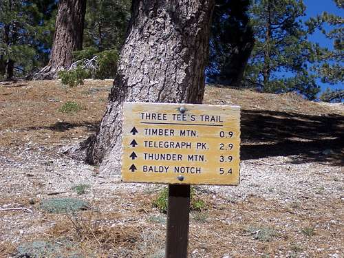
The Three Tee's Trail
The Three Tee's is a popular one way day hike encompassing Timber Mountain, Telegraph Peak and Thunder Mountain. All three rise high above the Cajon Pass creating the eastern flank of the San Gabriel Mountain Range.
The day hike generally originates from Ice House Canyon Parking Lot. Follow the well traveled trail along a small stream with oak and sycamore trees. Eventually the trail climbs out of the canyon to Ice House Saddle. At this point you have traveled 3.6 miles gaining approximately 2,600 feet in elevation. Several trails converge at the saddle. Watch for the Three Tee's Trail sign which would be to your left or north as you approach.
The ascent of Timber Mountain is a moderate hike that eventually loops over the summit plateau passing within a quarter mile of the true summit. A trail sign directs those who want to stop here and claim the summit. You have now come about a mile from the saddle gaining nearly 750 feet of elevation. Continuing on from Timber you begin your descent to the saddle between Timber and Telegraph, giving up nearly 500 feet of elevation before you start your climb up the southerly flank of Telegraph. From the saddle you will climb nearly 1200 feet of switchback trail before reaching the summit plateau. Once achieved you will note that the trail splits. One continues to the north side of the peak and down to Thunder and the second continues along the summit ridge another quarter of a mile to the true summit. You have now traveled 2.9 miles from Ice House saddle.
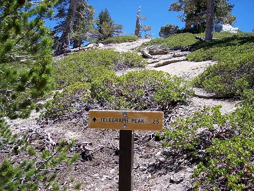
Trail sign at Ice House Saddle
Return now to the trail split and proceed one mile down the north side of Telegraph to the saddle at 8200' before climbing up to Thunder Mountain's summit at 8587'. From here travel along the dirt road the last 1.5 miles to the Mount Baldy Notch. From the notch you can elect to take the ski lift down when in season or follow the road the final 3.6 miles to Manker Flat. This puts your all in day at just over 12.5 miles.
Some prefer this trek in reverse order starting out at Manker Flat or nearly 1000 feet higher than from the Ice House Canyon trail head. Either route should include the use of a car shuttle.
|
|
|---|
|
|
|---|
Getting There
From Ice House Canyon
In the city of Upland exit the 210 freeway at N. Mountain Ave.(Exit 54)heading North up the hill. Follow Mountain Ave. for approximately 4.25 miles turning right onto Mount Baldy Road. In Approximately 5 miles you will reach Mount Baldy Village. Be aware of the reduced speed limits through the village. Continue on for 1.5 miles where you will soon reach the Ice House Canyon Parking on the left right side.
To do the route in reverse order originating from Manker Flat
Same route as above but continue beyond the parking area and up the winding switchbacks. Once you have topped out the road will soon divide with Northbound and Southbound traffic. You have reached Manker Flat. Park near the lower end of the ski area parking lot. Locate a gated road on the north side of Mt. Baldy Road and start walking. You’ll reach Baldy Notch after 1,500 feet gain and 3.5 miles. Pick up the fire road to the summit about 150 yards east of the Baldy Notch Restaurant. Another 1.5 miles and 800 feet gain will put you on the summit of Thunder Mountain where you can then continue onto Telegraph Peak. The first 3.5 miles can be eliminated by taking the ski lift (open weekends and holidays year-round). A late start will result in parking well down the road.
Note: During the winter with years of heavy snowfall this is a very popular roadway for residents of the Los Angeles Area heading to the Ski Lifts or just snow play. Travel up and down can take well over 90 minutes. An early start of 7:00 a.m. or earlier is strongly recommended.
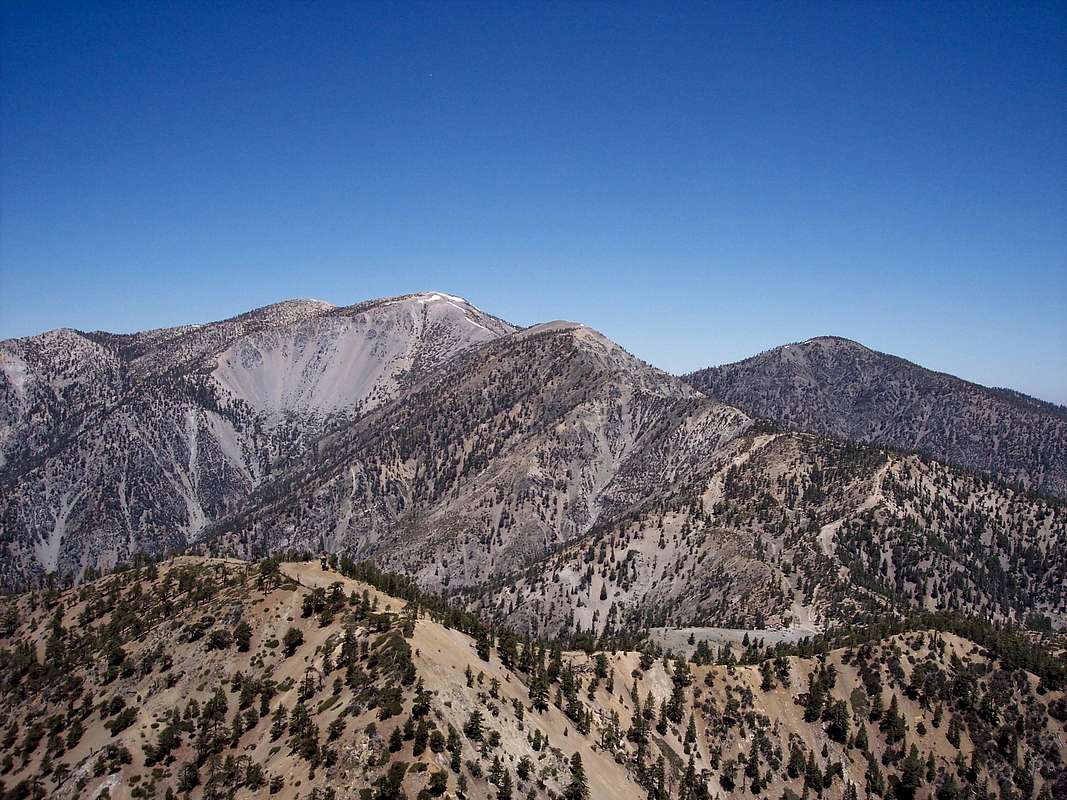
Mount Baldy and the Bowl, Mount Harwood in the center and Dawson Peak in the right background from the summit of Telegraph Peak.
Red Tape
Parking
A National Forest Adventure Pass is required for any parked vehicle at the trailhead. Fees are $5.00 a day or $30.00 for an annual pass. They can be purchased at any ranger station including the Mount Baldy Village Visitor Center (909-982-2829) located in the center of Mount Baldy Village or most sporting goods stores. Adventure pass
Cucamonga Wilderness Access
You must have a wilderness permit to enter the Cucamonga Wilderness. Permits can also be obtained from the Mount Baldy Village Visitor Center (909-982-2829). If you plan to start before 8:00 AM, call the visitor's center the day before and ask for a permit. They will place it on the bulletin board out in front and you can pick it up in the morning, en route to the trailhead.
Camping
Most people will generally day hike in the Cucamonga Wilderness area. For those who want to camp there are two options, Kellys camp and Manker Campground.Kellys Camp
Note: This will take you one mile away from your objective
From the Ice House Saddle take the Ontario Peak Trail for about 1 mile gaining approximately 200 feet in elevation to approximately 7800 feet. In the trees you will notice stone foundations for cabins that were here in the past. This is an undeveloped campsite with plenty of space for overnight camping. There is a water source here but it is very unreliable. You are better served bringing water from Columbine Spring on the trail to Ice House Canyon Saddle. It runs year round and is marked as A on the link
Manker Campground
This campground is located at Manker Flats, approximately 2.5 miles north of the Ice House Canyon parking lot at an elevation of 6,000 feet. It has 21 pay sites offered on a first come first serve basis. Click here for more details: Manker Campground.
External Links
Mount Baldy Ski Area Map
Angeles National Forest Web Site
Angeles National Forest Map