
-
 25335 Hits
-
 81.17% Score
-
 13 Votes
|
|
Mountain/Rock |
|---|---|
|
|
46.97394°N / 11.72667°E |
|
|
Bolzano Alto Adige |
|
|
Hiking, Mountaineering, Skiing |
|
|
Spring, Summer |
|
|
11512 ft / 3509 m |
|
|
Overview
Gran Pilastro - Hochfeiler 3510 m
Gran Pilastro - Hochfeiler 3510 m is a majestic peak located on the Italian-Austrian border and belonging to the Alpi Aurine/ Zillertal Alps. More precisely, to the North is Austria, to the South the autonomous Italian region of Süd Tirol (which translates to English as South Tyrol). As all the mountains located near the boundaries between Italy and Austria, this peak has two names: Gran Pilastro, the italian name, and Hochfeiler, the original tyrolese place-name. It is the highest mountain in the Alpi Aurine - Zillertal Alps, with an imposing profile especially when viewed from the Austrian side, where it falls with an impressive almost vertical wall. In fact the North face towards Austria is almost completely covered with ice and forms a steep frozen wall 300 meters high, on which one of the most famous routes of classical mountaineering is located: the "Hochfeiler-Eiswand". This routes is particulary important from the mountaineering point of view.
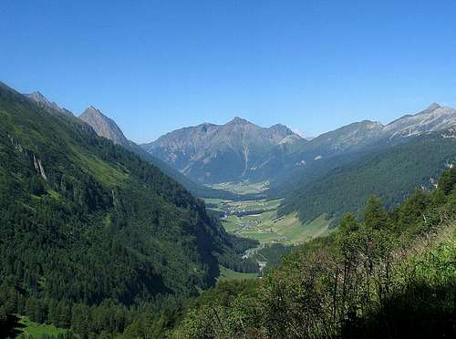
Starting points from South Tyrol to climb the Gran Pilastro are Val di Vizze and furthermore Lappago, a village in the Valle di Tures, where you can climb up to the Rif. Passo Ponte di Ghiaccio. The mountain in fact has two normal routes, one that climbs from the Vipiteno and the Val di Vizze and the other that passes through the Valle di Tures.
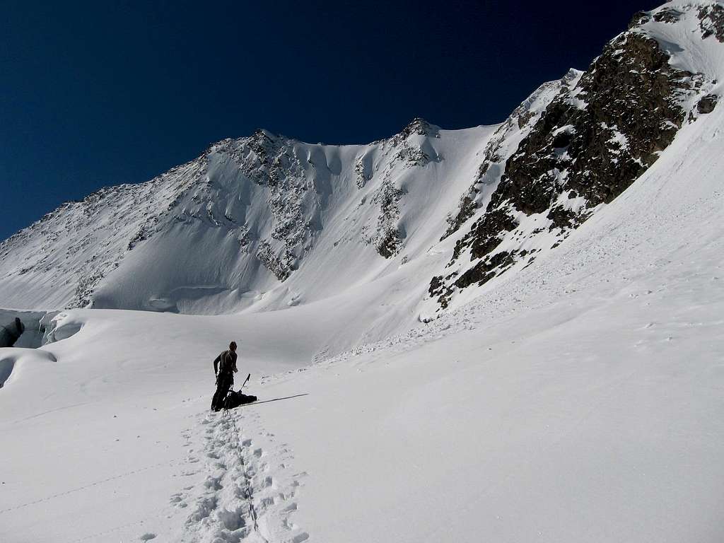
It is an ascent that takes place mainly on a glacier, with a mixed stretch and some easy moves on stepped rocks to reach the 3250 m saddle on the South-West ridge and a narrow and exposed snowy ridge in the final stretch, which requires a minimum of experience and foot safety. The Normal route is an unforgettable climb. Although it does not require particular technical skills, it is a satisfying route on terrain mainly of snow and ice, with a last short stretch that is quite exposed.
From the geological point of view it appears to be formed by gneiss covered in the upper part by green slate.
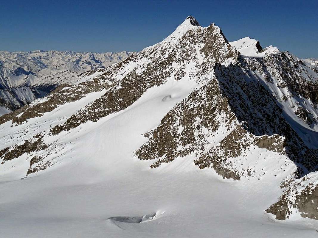
Three long ridges, North-West, East and South-West separate 3 big glaciers: the Schlegeiskees (North East), the Gliderferner (South) and the Weisskarferner (North West). Along the southwest ridge there is the easiest route.
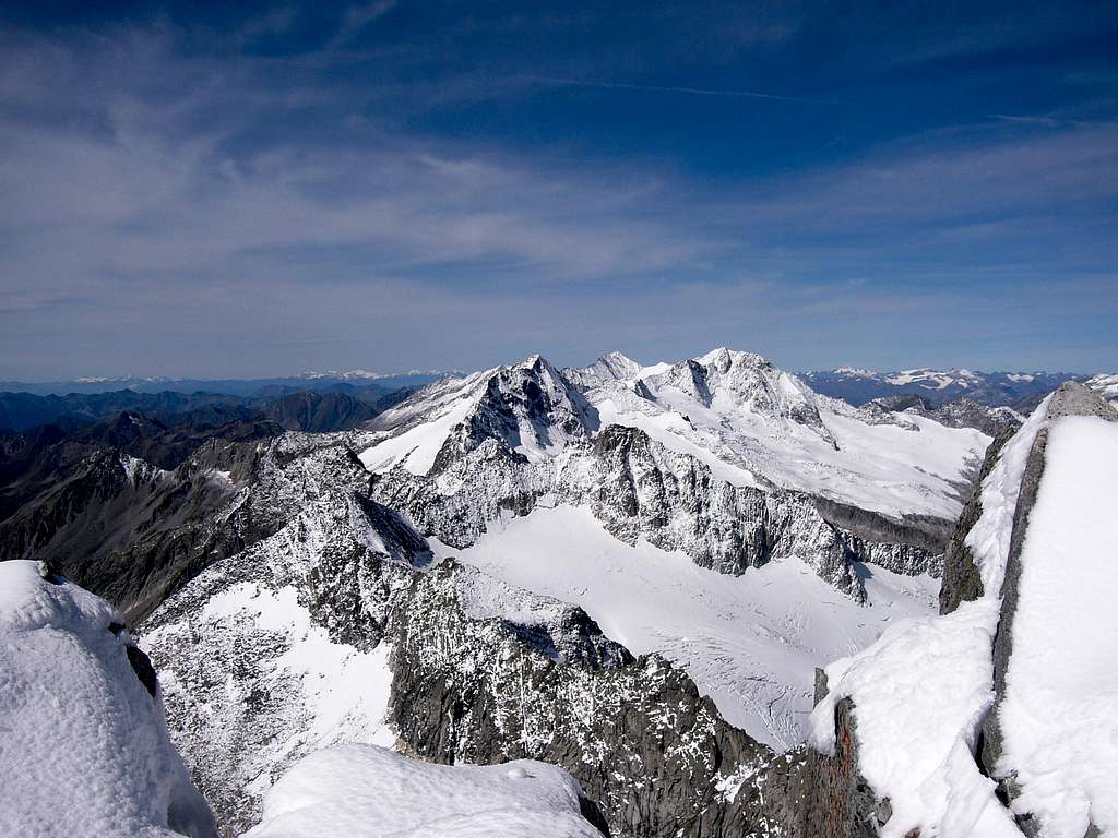
From the summit the 360° panorama is particulary attractive and wide: Tuxener Alpen, Venedigergruppe, Dolomites, Pfunder Berge, Stubaier Alpen, Vedrette di Ries.
History
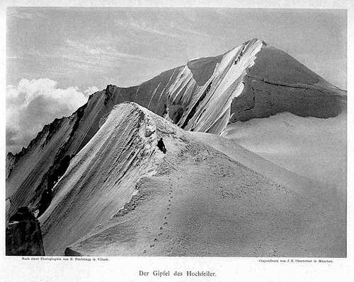
The Normal route along the SW ridge follows the itinerary of the first ascent of the Gran Pilastro, which took place on July, 24th 1865, just 10 days after the first ascent of Matterhorn. It was realized by the mountaineer Paul Grohmann, co-founder of the Oesterreichischer Alpenverein, the Austrian Mountaineering Association, with the mountain guides Peter Fuchs and Georg Samer "Josele" of San Giacomo in Vizze di Dentro. The ice face to the north can be climbed from the Schlegeistal valley in North Tyrol: the first ascent took place in 1887 by F. Dyck and Hans Hörhager.
The traditional name of the mountain, still in 1700 was Hoch Feil Spiz and was probably referred to a nearby area, the Fäule (dialect Faile) that means "swampy land". The Italian name was created by Ettore Tolomei after the WWI, but it has nothing to do with the original Tyrolean toponym. Probably it is a misinterpretation of the word "-feiler" wrongly translated with "Pfeiler", that instead means Pillar (Pilastro in Italian).
Getting There
Road access
- from Valle Aurina
From Brunico (Val Pusteria) we head towards the Ahrntal Valley to take the Molini valley just before Campo Tures, which leads to Lake Neves 1860 meters, where the road ends.
- from Val di Vizze
From Vipiteno, you have to go as far as the center of Sasso / Stein, towards the end of the Val di Vizze, where it begins a dirt road; from here continue until the third bend, where there are several places to park the car, at an altitude of 1718 m.
Walking approach to Rifugio Ponte di Ghiaccio 2545 m
From the car park near Lake Neves, start by initially following the service road that surrounds the shore of the lake, reaching the Malga Comunale at about 1860 m. From here continue along the path (with trail n. 26) that climbs to the right of the valley, passing a beautiful wood with a dense series of hairpin bends and exiting onto a vast grassy plateau. Continue through pastures and grassy slopes and then through stony ground, aiming for the obvious hill, the Passo Ponte di Ghiaccio where it's located the Refuge Ponte di Ghiaccio m. 2545 (2 hours from Lake Neves).
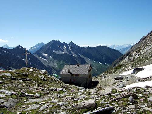
Walking approach to Rifugio Gran Pilastro (Hochfeilerhütte) 2710 m
The classic hike to the Refuge Gran Pilastro begins at the third curve of the road towards Passo di Vizze 1718 m, located within the Val di Vizze and goes through the Valle di Sottomonte (Unterberg Tal). There are several parking options on this bend. Here take the trail n. 1 in the direction of the hut. After about fifteen minutes you cross a wooden bridge on the right over the Rio di Sopramonte - Oberbergbach and after a gate continue uphill through woods, bushy slopes, pines and meadows interspersed with stones and rocks. Overcome a rocky passage with the help of a fixed rope. Continuing along the well-marked path in a magnificent high mountain scenery, you will finally reach the refuge. Near the Hochfeilerhütte it appears on the right the Gliederferner glacier.
Routes
SW ridge (Normal route from Rifugio Gran Pilastro)
Difficult: F+/PD- depending on the conditions of the last 50 m ridge
This was the route of the first ascent, quite interesting from the environmental and panoramic perspective. A classic route.
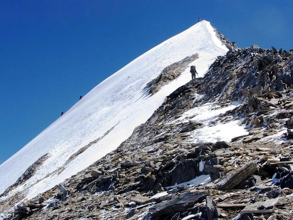
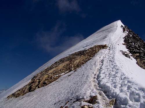
From the back of the refuge, continue briefly uphill in the NW direction ("Hochfeiler" sign) and then climb a short steep gully along an aided section (ropes and pegs) leading to the ridge above. Turn to the right maintaining the ridge above the refuge on the right until you reach an area characterized by vertical rocks embedded in the ground resembling gravestones. From here you cut diagonally and then climb up steep rocks (ropes) and then emerge on the ridge, where we can see on the other side the Weisskarferner. The summit now appears in all its majesty. Still a slightly uphill stretch (exposed) to then tackle the steep final ridge that leads to the summit cross.
This last part can be very variable, depending on the presence of snow or ice. The last 50 m. up the summit are quite exposed on both sides and, as they are frequently covered by snow or ice, they require crampons and ice-axe. In the not frequent case in which this last part is free from snow, it becomes an easy climb on rock. (2.45 h from the hut).
SW ridge (Normal route from Rifugio Ponte di Ghiaccio)
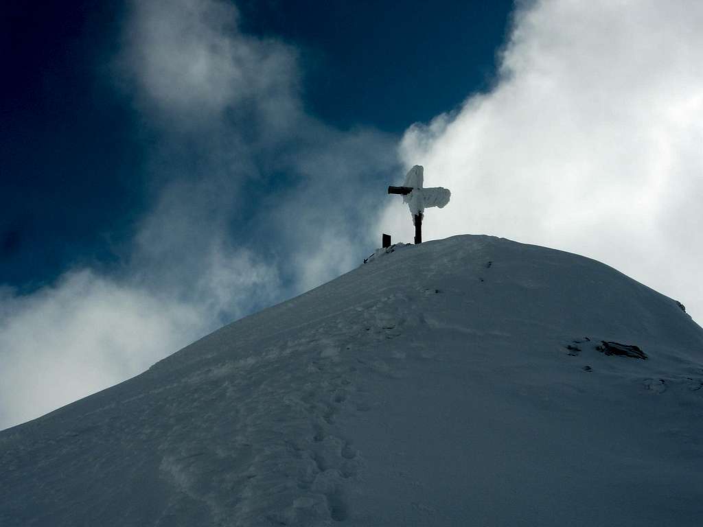
From the hut follow the path n. 1 and signposts to the Gran Pilastro (Hochfeiler), climbing halfway up on the right into the Untergries valley, crossing grassy stretches and then a steep detrital ramp until you reach the wide Forcella di Punta Bianca m. 2928. From the saddle you can clearly see the Gran Pilastro and the remaining part of the itinerary to follow. You descend on snow or stones until you reach the underlying glacier (the Vedretta del Gran Pilastro). Cross the glacier with a large semicircle to the right following the existing tracks (be careful when crossing some large crevasses). Leaving the glacier, go up a rocky ramp with large stones on the right, following the cairns present on the spot. Continuing on a fairly steep snowy slope you reach a notch at an altitude of 3250 m. on the southwestern ridge of the Gran Pilastro. Turning to the right you follow the snowy ridge (usually there is a good track) which in the final part becomes narrower and more exposed, until you reach the summit, where there is a large wooden cross. Downhill, the same ascent itinerary is retraced backwards.
NW Face
Short ice ascent, not very often repeated.
Difficult: PD+/AD whit icy slope up to 45°
Red tape
No fees no permits required
Huts
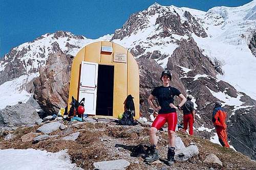
Rifugio Ponte di Ghiaccio
Gran Pilastro Hut / Hochfeilerhutte
The Gran Pilastro hut /Hochfeiler Hütte 2710 m is one of the ideal starting point to the summit of Gran Pilastro/Hochfeiler. Located in a fine panoramic position on a small terrace, over the Glideferner glacier, it's a good logistic point also for ascent to Punta Bianca/Hoher Weisszint 3370 m. and Cima Grava/Hochfernerspitze 3470 m. Opened in 1986 from the Sterzing section of the AVS, it offers 90 beds.
Open from mid June to the end of September, while the winter room offers 6 beds.
Guardian: Hernegger Andreas
Hut phone:+39 0472 646071 Mobile:+39 340 793 18 69 E-mail:info@hochfeilerhuette.it Web site: www.hochfeilerhuette.com
Gunther Messner Biwakschachtel
Günther-Messner-Bivouac on 2429 m
Located at 2429 m. at the base of Griessferner and Hocferner steep walls.
Renewed in 2000 is always open , with 9 beds. Startpoint for the very difficult ice routes on Hochfeiler, Hochfernerspitze, and Hintere Weisspitze.
When to climb
Mountaineering: June-September
Ski-mountaineering: March-May
Meteo
Guidebooks and maps
- Alpi Aurine - F. Cammelli, W. Beikircher, Club Alpino Italiano - Touring Club Italiano, 2002
- Alpenvereinsführer Zillertaler Alpen - Heinrich Klier, Walter Klier, Rother Verlag München (1996), ISBN 3-7633-1269-2
- Zeitschrift des Oesterreichischen Alpenvereins, Band II, Seite 127, Wien 1870/71
- Die Erschließung der Ostalpen, III Band - Carl Diener in Eduard Richter (Redaktion), Berlin 1894
- Geologie von Tirol - Raimund von Klebelsberg, Berlin, 1935
Maps
- Alpenvereinskarte 1:25.000, Blatt 35/1
- Tabacco-Verlag, Udine, carta topografica 1:25.000, Blatt 037, Hochfeiler-Pfunderer Berge