
|
|
Mountain/Rock |
|---|---|
|
|
38.90520°N / 114.6286°W |
|
|
White Pine |
|
|
Hiking |
|
|
Spring, Summer, Fall, Winter |
|
|
9964 ft / 3037 m |
|
|

View eastward
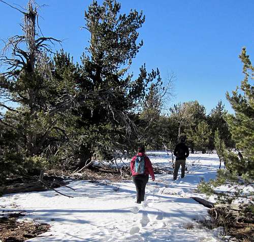
Tracking through the snow
Overview
This unknown mountain is seen easily from the summit of Wheeler Peak as you look westward from Wheeler's lofty summit but unless you know what you are looking for, you will probably not know which mountain it is. Most likely your eyes will be drawn to Mt. Grafton which is south of this mountain. Asyou approach Majors Junction where highways 93, 6/50 come together, this mountain is the dominant one just to the south (see pic).
Major Benchmark mountain is of interest to that small group of peakbaggers who chase prominence peaks since this mountain is one of Nevada's peaks with over 2000 feet of prominence. It can be mentioned that this one is a bit confusing name wise. Peakbagger.com refers to it as Major BM West and gives the elevation as 9964 while List of John simply calls it Major BM and lists the elevation as 9940. The confusion is resolved however by visiting the peak itself and you find that the benchmark area is lower by that 24 feet and is marked by a small cairn and a glass bottle register. In looking at the topo map, you also will note a Schell BM located just to the west but again, by visiting the peak, we found that this was lower than the highest spot marked accurately on the topo found at peakbagger.com. Still, even though it is lower, I'd recommend making the effort to visit the Schell Benchmark while you are there, it isn't that much of an effort to add it to the hike. OK, moving on.
With a prominence of 2160', Major BM comes in at 143rd on the Nevada prominence list. Not all that high on the list but it lacks only 36 feet from being 10,000 feet high.
Getting There
Ely is the nearest town of any size and from Ely, head south on US 6/50 about 15 miles and watch for a sign that indicates a Nevada prison off to the right. Take the road that goes by the prison and continue on it for close to 4 miles to a signed "Y" junction. Take the left fork towards Horse & Cattle Camp loop. The right fork heads for the Ward Charcoal Kilns and Bushwhack summit. This is a good quality dirt road that you follow for another 8 miles. A rougher track takes off to the left (see map) and if you have a high clearance 4WD vehicle, you can get closer to the mountain. However, you could park at this point and walk up the road from that turn off. You will find yourself at 7600' of elevation and the remainder of the information will be found on the route page.For those coming from Utah via Delta and the Great Basin National park, the turn off for the prison is about 10 miles from Majors Junction (where highways 93 and 6/50 meet). Watch for the prison sign, the prison is off to the left and prior to reaching the turn off, you will be advised that there is no hitchhiking allowed in this area.

Map of the area
Red Tape
None that I am aware of. There were no gates to go through or indications of private property issues.
The sign
Camping
You could car camp in the area and where we parked for our "trailhead" would've worked fine. Be sure to have your own water and practice leave no trace camping ethics.Ely has many nice motels and we stayed at the La Quinta after the hike and was very pleased. Other nice motels are the Bristlecone and Best Western. We visited in January so camping out didn't appeal with the temperatures dropping to single digits at night.
Our route
John Vitz provided some helpful information that I found at the yahoo prominence group page:"Major/Schell BM (2K). A combination of good roads and poor jeeps trails will
get you to the pass south of the peak. From here, go almost over the top of the
peak west of the pass, north along the ridge to a break, down to the flats and
walk to the two summits. It turns out that neither BM is the true high point.
Major BM is about 100 yards east northeast of the true high point, near the edgeof the summit plateau and Schell BM is obviously lower."
Greg and Kadee had visited the area back in October but didn't have time to get the mountain. They did find the best jeep trail by exploring by checking out the "poor jeep trails" that John Vitz mentions. The map shows two other possibilities just north of the road we took up so ours isn't the only road that would probably work. I have created a map that will show our route and the jeep track that we utilized. GPS waypoints are
provided in the lat/long nad 27 form.
Leaving the good dirt road at the 8 mile mark, we took a rough jeep track that had recent tire marks on top of the snowy sections. After 0.6 of a mile, we found a steep, area that it took the lowest 4 wheel gear to get past due to some loose goughed out area. After that little section, the jeep track continued up and it was easier going the further up we went.
Another road came in from the west and we joined up with that one and continued on until we reached a spot where the road dropped steeply down to a saddle. Rather than drive that last section of road, I elected to stop and we walked in from there. See the map for our general route. From where I parked it was three miles to the summit and had a combined 1600 feet of elevation gain. It was mainly class 1 hiking with some class 2. Nothing difficult and overall a very pleasant hike.

 |  |  |
Route GPS
As the GPS waypoint readings are sometimes hard to read, here is a listing of the key ones for those who really might be serious about following the route we took: (lat/long nad 27)The Highway turn off to the west (go past the prison)
39.0485 114.7232
drive 4 miles and take left fork
38.9957 114.7549
drive 8 miles and watch for jeep road on east side of road
38.8979 114.6910 (7600'
drive 0.6 miles and jeep road steepens and may be where you need to park
(on north side there is a small area where two vehicles can park)
You might want to park and walk the road to see if your vehicle can deal
with the rough section. It took my truck three tries in extra low gear to make it past this section. Above it, the road was better
38.8907 114.6851 (8000')
Making it past the steep rough section, I then drove to 8480 and parked
38.8846 114.6646
Dropping down to a saddle, we walked up to the end of the road and started our cross country effort. End of road was about 8550
38.8853 114.6606
Waypoint at 9050
38.8901 114.6463
Waypoint at 9530
38.8975 114.6404
Then on to the summit area
This was the route that worked for us. Other possibilities exist that should work as well.
Ely Nevada weather

Click for weather forecast

Click for weather forecast
Lonely summit

8 years between visitors
2003 - John Vitz
2012 - Kadee Smith, Greg Jagielski, myself
2014 - Ken Jones, Bob Packard, Richard Carey and Adam Helman
Disclaimer: When you do this mountain and utilize the information provided by me, you do so at your own risk. The information provided on this summitpost page is for information purposes only and it is possible that you could get injured or worse while attempting to reach or descend from this summit.