
-
 8906 Hits
-
 80.49% Score
-
 12 Votes
|
|
Mountain/Rock |
|---|---|
|
|
38.97850°N / 78.6313°W |
|
|
Shenandoah/Hardy |
|
|
3293 ft / 1004 m |
|
|
Overview
Great North Mountain is located on the border between Virginia and West Virginia. The highest point on Great North Mountain is Mill Mountain, which is 5.5 miles north of Wolf Gap. Mill Mountain also ranks as the highest point in Virginia's Shenandoah County. All of the routes to the summit involve hikes of at least 9 miles.
Although there are no summit views from Mill Mountain, side trips to neighboring peaks along the routes to the summit lead to spectacular views. From Halfmoon Mountain, it is possible to see Long Mountain, Mill Mountain, and Trout Run Valley. From Big Schloss, it is possible to see the Blue Ridge, the Massanutten, and the Shenandoah Mountains, and many of the peaks on Great North Mountain, along with the Shenandoah Valley.
Getting There
Halfmoon Mountain Trail: From Woodstock, go south on Route 42 until reaching SR 675. Turn right and follow SR 675 to Wolf Gap, where it enters West Virginia. Continue on this road, which is now CR 23/10. After another 5.5 miles, turn right on FR 509 and follow it until reaching the closed gate in front of the bridge. Park on the right side.
Walk across the bridge, and you will be on the yellow-blazed Halfmoon Montain Trail. Follow this trail for 3.2 miles; the ascent through the woods is mostly gradual. At this point, you will reach the intersection with the blue-blazed Tuscarora Trail. There is also a white-blazed side trail that leads to views of Trout Run Valley. Turn right at the blue-blazed Tuscarora Trail and follow it for 0.9 miles. Turn right at the orange-blazed Mill Mountain Trail and follow it for 0.5 miles until reaching an short, unblazed side trail. Make another right at the unblazed trail, which leads to the shed at the summit of Mill Mountain.
To see the views from Halfmoon Mountain, turn left at the white-blazed Halfmoon Mountain Lookout Trail after following the Halfmoon Mountain Trail for 2.5 miles. Hike on the Halfmoon Mountain Lookout Trail for 0.7 miles. At this point, the left fork of the trail leads to views of Mill Mountain and the Great North Mountain ridge. Return to the main trail, and follow it for a steep and rocky 0.1 miles to the summit, where there are views of Trout Run Valley, Long Mountain, and the ridges to the west of Great North Mountain.
Round trip: 9.4 miles with an elevation gain of 1,700 feet. Add another 1.6 miles and 300 feet of elevation gain for the side trip to Halfmoon Mountain.
 Mill Mountain |
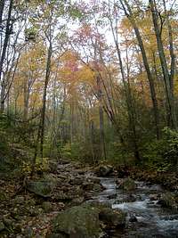
 Trout Run Valley Trout Run Valley |
 Ridges in WV |
Little Stony Creek Trail: From Woodstock, go south on Route 42 until reaching SR 675. Turn right and follow SR 675 to FR 92. Turn right here and follow FR 92 for 3.7 miles to the Little Stony Creek Trail parking lot, which is on the right side. Park here and cross the road.
Hike for 3.6 miles north on the yellow-blazed Little Stony Creek Trail to the intersection with the Tuscarora Trail. Turn left, and follow the Tuscarora Trail for about 0.6 miles. Make another left at the Mill Mountain Trail and follow it for 0.5 miles. Turn right at the unblazed trail, which leads to the shed at the summit of Mill Mountain.
Round trip: 9.4 miles with an elevation gain of 1,800 feet.
 |
 |
 |
 |
 |
 |
Mill Mountain Trail: From Woodstock, go south on Route 42 until reaching SR 675. Turn right and follow SR 675 to Wolf Gap.
Start hiking on the Mill Mountain Trail. After 0.8 miles, there will be a lookout on the left where it is possible to see the Massanutten Mountains from end to end. Starting from the far left, you will see Signal Knob and Meneka Peak at the northern end of the mountains. As you continue to the right, you will see Little Crease Mountain, Kennedy Peak, and then just before the first gap in the mountains, Opechee and Waonaze Peaks. Big Mountain rises from New Market Gap, which is the second gap in the mountains. Further to the right, you will see the three peaks of Morgan Knob, and then Grubbs and Lairds Knobs. Finally, at the far right, Massanutten Peak is at the southern end of the mountains.
After 1.8 miles, turn right on the white-blazed Big Schloss Trail and follow it for 0.25 miles to the views at the summit of Big Schloss. To the east, you can see all but the northern end of the Massanutten Mountains with the peaks of the Blue Ridge in the North and Central districts of Shenandoah National Park behind them. To the right of New Market Gap, some of the higher peaks of the Blue Ridge such as Hawksbill and Stony Man rise more than 3,000 feet from the valley floor. Massanutten Peak at the southern end of the Massanutten Mountains is already 35 miles away. To the right of Massanutten Peak, you can see some of the peaks of the Blue Ridge further to the south. If you get out a map and figure out the lines of sight, these mountains are about 55 to 60 miles away!
Continue looking to the right and see the peaks of Great North Mountain. Directly to the south is Tibbet Knob; the Great North Mountain ridge makes a turn at Tibbet Knob and continues to the right before making another turn at Devils Hole Mountain. Just to the south of Devils Hole Mountain are Devils Benchmark and Point 3219. If you look further to the south, you can see Great North Mountain all the way down to its southern end. Off in the background behind Great North Mountain is Shenandoah Mountain in West Virginia (not to be confused with Shenandoah National Park).
Continue to the right, and see the ridge of Long Mountain to the east and northeast. To the north, you will see from left to right Halfmoon Mountain, Mill Mountain, and Sugar Knob. Finally, completing the circle is Little Sluice Mountain to the northeast.
Return to the Mill Mountain Trail, which goes through some small ups and downs before reaching a spring after 4.4 miles. From the spring, the trail starts to ascend and becomes rockier. After 5.5 miles on the trail, make a left on the side trail that leads to the summit.
Round trip: 11 miles with an elevation gain of 1,900 feet if you really want to skip Big Schloss. Add 0.5 miles and 200 feet of elevation gain if you want to take in the views.
 |
 |
 |
 |
 |
 |
Red Tape
Mill Mountain and the routes to its summit are on public land in the George Washington National Forest. There are no fees or permits required for hiking or camping.
Camping
Free camping is permitted throughout the George Washington National Forest except in the immediate vicinity of picnic areas and a few other locations. Don't stay in the shed at the summit of Mill Mountain. It's full of yucky dead bugs.
Halfmoon Mountain Lookout Trail: From the junction with the Halfmoon Trail, follow the Halfmoon Mountain Lookout Trail for 0.4 miles to the pink-blazed German Mountain Trail. Turn right and follow the German Wilson Trail for 0.1 miles to a campsite. There are also small campsites near the Halfmoon Mountain summit.
Little Stony Creek Trail: There are numerous campsites along this route, particularly between 1.1 and 1.3 miles from the trailhead. Another campsite is on the Tuscarora Trail just past the junction with the Little Stony Creek Trail. The Sugar Knob Cabin, which is maintained by the Potomac Appalachian Trail Club. is on the Little Stony Creek Trail about 3.5 miles from the trailhead. This little stone 10X10 cabin can accommodate four guests.
Mill Mountain Trail: There is a campsite 0.7 miles from the trailhead.
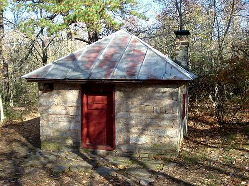 Sugar Knob Cabin
When to Climb
Mill Mountain can be climbed nearly all year round. The hike can be particularly delightful from mid-October through mid-November because of the autumn colors. July and August are the worst months for heat, humidity, haze that limits views, and hostile little critters like ticks, yellowjackets, and mosquitoes. The best time for a summer hike is early in the morning.
Hiking should be avoided in the National Forest when it is permissible to hunt deer with modern firearms. In 2019, Virginia's deer season runs from November 16 through November 30. In West Virginia, deer season runs from November 25 through December 7, from December 19 through December 21 and from December 28 through December 31.
External Links
George Washington National Forest- Lee Ranger District
The Potomac Appalachian Trail Club maintains the trails on Great North Mountain, and provides maps, guidebooks, and other information.