
-
 36025 Hits
-
 87.31% Score
-
 24 Votes
|
|
Mountain/Rock |
|---|---|
|
|
39.04229°N / 106.59734°W |
|
|
Hiking, Mountaineering, Scrambling, Skiing |
|
|
Spring, Summer, Fall, Winter |
|
|
13988 ft / 4264 m |
|
|
Overview
Grizzly Peak A is the highest ranked 13er in Colorado at 13,988 feet. This puts it at number 54 in Colorado and well worth a climb. It is located in the northwestern portion of the Sawatch Range of Colorado and is at the head of McNasser Gulch. Neighboring Garfield Peak can be added to a climb of Grizzly to make for a very enjoyable class 2+ traverse. Grizzly Peak does hide a very nice mountaineering route, possibly the best in the Sawatch. The Grizzly Couloir usually holds quality snow well into the summer and is ranked a steep snow climb meaning the maximum angle of ascent exceeds 45 degrees. Take advantage of this premier route as good mountaineering routes in the Sawatch are few and far between.
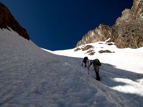
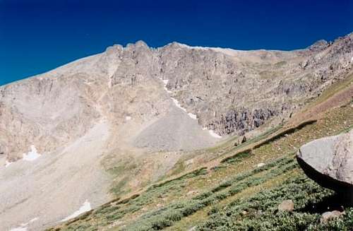 Grizzly Peak A from McNasser Gulch
Getting There
The standard trailhead for Grizzly Peak A is the McNasser Gulch Trailhead. Get here by heading west from Denver on I-70 for about 70 miles and take the Colorado Highway 91 exit. Head south on this road, over the 11,500 foot Fremont pass and to Leadville. Continue south from Leadville 15 miles on Highway 24 to the CO 82 (Independence Pass) road junction. Turn right here and drive west along the Twin Lakes and past the small town of Twin Lakes. Be careful not to speed through here as the cops are anal through that little town. Continue on CO 82 until you get to the La Plata Trailhead on the south side of the road after 14 miles from Highway 24. In the winter, this is where you will be forced to park unless you have a snowmobile.
In summer, cars can usually continue to the south on the South Fork lake Creek Road (FS 391) which continues right from the small parking lot off the highway. After 3.3 miles the trailhead is reached at the junction of FS 391 and FS 394 where 2WD cars should park. With a 4WD vehicle you can continue up the steep FS 394 to the right (northwest) as it climbs into McNasser Gulch for about a mile before reaching a locked gate that marks the wilderness boundary.
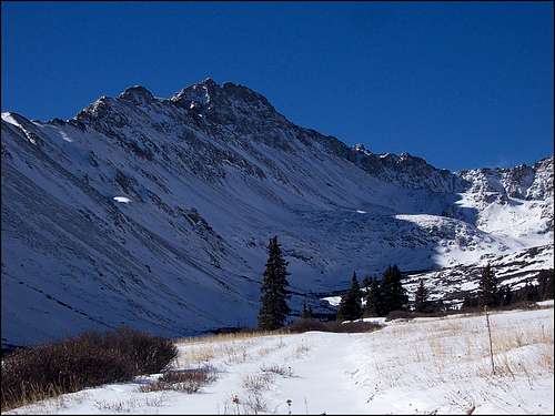 View from McNasser Gulch with Snow
The other trailhead for Grizzly Peak A is used for climbing the Grizzly Couloir. This is the Grizzly Reservoir Trailhead and is accessed by heading east on CO 82 for 10 miles from the town of Aspen. From here, turn south onto the Lincoln Creek Road (FS 106) for 6.5 miles passing the Lincoln Gulch campground and the reservoir along the way. Keep in mind this road is suitable for tough passenger cars. Fancy low-rider cars will likely be damaged on this road.
Route Options
East Ridge/McNasser Gulch
This is the standard route on Grizzly. It is not the best way to climb Grizzly Peak but the ridge itself can offer a decent scramble. The 800 foot climb up the south facing slopes to gain the east ridge is one of Colorado's more painful ball bearing slopes that might have you slip-sliding away. Plan on a one step up two step slide the whole way up...or down!
At that rate you may never make it!
Anyway, begin by walking the continuing road past the locked gate at the 4WD trailhead for about a mile. At 11,750 feet continue right at a road junction and climb to an old mine where the road ends. Walk west for a half mile on open gentle talus and at 12,500 be sure to grit your teeth, say your prayers and get ready for battle. The next 800 feet really suck but when you reach 13,300 feet at a small saddle the hard work is over. Scramble the class 2+ ridge for another half mile to the summit, passing over a minor summit and the col at the top of the Grizzly Couloir enroute. This route is 8 miles RT and 3,200 feet of elevation gain from the lower 2WD trailhead.
 Looking down at Grizzly Lake Looking down at Grizzly Lake |
 Traversing the east ridge Traversing the east ridge |
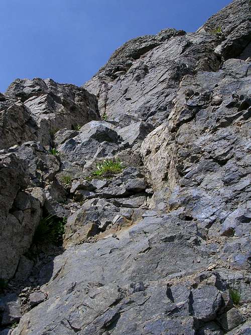 Scrambling to the false summit
South Ridge via Garfield Peak
See the above link for information about ascending Garfield Peak. From this 13,780 foot peak, the traverse north to Grizzly Peak A starts with a 300 foot, 0.3 mile Class 2+ descent to the 13,400 saddle then another 0.7 mile Class 2 ascent to the summit.
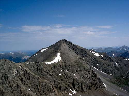 A look at the traverse to Grizzly Peak
Grizzly Couloir/Grizzly Reservoir Trailhead
This is the route I would recommend on this peak. Do it in late spring or early summer for the best conditions. Start by hiking for 3 miles to Grizzly Lake with a 12,500 foot elevation on the well defined Grizzly Lake Trail. Round the lake on its north side and climb the obvious couloir leading straight up. At times it will exceed 45 degrees but with the right equipment this is a relatively straightforward climb and has a much lower rockfall danger than the Fridge couloir on Ice Mountain. Upon reaching the col, scramble south a short distance over class 2+ terrain to the summit. Descend the West Slopes back to the Lincoln Creek Road and walk north on the road back to your car.
For more information on this route see This Page
 Ascending the Grizzly Couloir
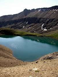 Grizzly Lake Grizzly Lake |
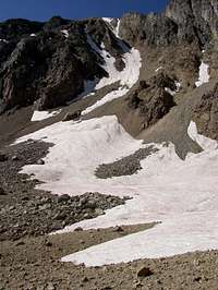 The Grizzly Couloir The Grizzly Couloir |
Map
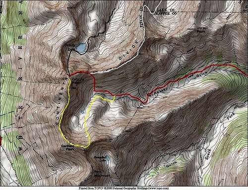 Topo map showing various routes on Grizzly Peak courtesy of SP user Kane
Camping/Red Tape
Camping for this peak really doesn't make much sense. The peak can be easily climbed in a day however if you are so inclined to do so, there are some nice open areas near Grizzly Lake. It's probably best just to camp at the trailhead. Beware of the private property on the McNasser Gulch Road though. Be sure to completely pass through before camping alongside the road.
Grizzly Peak lies in a wilderness area. No motorized equipment is allowed past the gate. Please try to avoid camping on fragile tundra and practice leave no trace policies.
External Links

Garfield Peak
See Gerry Roach's Colorado 13ers book for very detailed descriptions about the approaches and routes to these mountains.
Weather Forecast
Good Trip Report
Lists of John
McNasser Gulch Current Conditions
Independence Pass Info
City of Leadville