

-
 33283 Hits
-
 93.47% Score
-
 43 Votes
|
|
Mountain/Rock |
|---|---|
|
|
37.80480°N / 107.8248°W |
|
|
San Juan&San Miguel |
|
|
Hiking, Scrambling |
|
|
Summer, Fall |
|
|
13780 ft / 4200 m |
|
|
Overview
This page was developed by Mark Didier, and he transferred it to me because he felt that I live close by and can update it more frequently. Thank you Mark for the wonderful page. Golden Horn is one of over a half dozen 13ers that rise up majestically to the west of Ice Lake Basin in Colorado’s San Juan Range. From a distance Golden Horn looks more intimidating than many of its nearest neighbors, but upon a closer look the Class 2+ standard route up the southwest ridge makes for a great day hike - with a little bit of that classic loose San Juan scrambling thrown in for good measure. Golden Horn is one of Colorado’s bicentennial peaks, which means it is among the highest 200 peaks. Many people after finishing 14ers, set up their goal to reach the highest centennial and bicentennial peaks in Colorado. At 13,780 feet it ranks as the 117th highest peak in the state, and has 400 feet of prominence. Of all the peaks in the San Juans to choose from, why climb Golden Horn? It is a beautiful peak, in a beautiful basin, with a route that offers a fun scramble, outstanding views from the summit and it has a second (lower) summit, which allows for some Class 3 scrambling.
If planning a 3 summit day, the peak can be nicely combined with Fuller Peak 13,761 feet, and Vermilion Peak 13,894 feet without adding too much distance. The best way to approach it is to summit Fuller-Vermilion saddle and bag those peaks. If you descent slightly down from the above mentioned saddle and contour below Vermilion Peak on its east side to Vermilion-Golden Horn saddle, you will find your easiest way up Golden Horn. The photo on the left shows the proximity of all those three peaks. Vermilion Peak has Colorado rank 74 (74th highest peak), it is a centennial peak and a very popular one to claim. Colorado Rank: 117
Parent Lineage: Vermillion Peak
Class: 2+
Ice Lake Basin
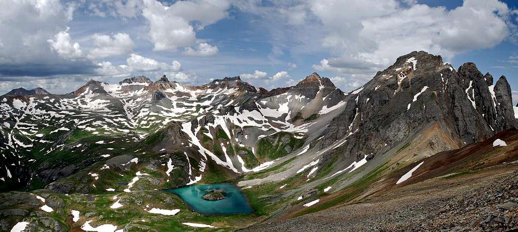
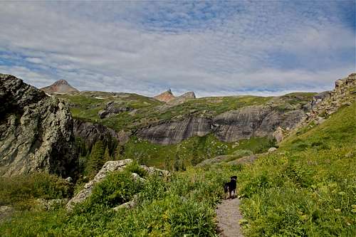
As the name suggest, Ice Lake Basin lies high above timberline in the San Juan Mountains. The closest town would be Silverton (nice historic town, definitively worth to explore). Ice Lake and its neighboring lakes are frozen for at least eight months of the year. There are four named lakes within the basin and 6 unnamed ones, all remnants of the glaciers that long ago created the bowl shaped valley.To the west the basin is bordered by a long crescent shaped ridge of 13,000 foot peaks, which offer interesting scrambles. The most pretty lake is Island Lake (see photo below), which is not on the trail to Golden Horn. Island Lake lies below US Grant. Some say that Island Lake is possibly the coolest alpine lake in Colorado. As the name says, it has a spooky eyeball-ish look to it.![Ulysses S Grant Peak]() The Peaks of Ice Lake Basin by KaneMany would argue that Ice Lake Basin is one of Colorado’s most beautiful basins. Whether it is the most beautiful can be argued all day but regardless, you will not be disappointed if you spend some time here. The lower basin has beautiful cliff carved walls, with a large number of waterfalls running down from the upper basin. The lower Ice Lake Basin is clearly separated from the upper basin by massive 400 ft granite wall. During early season snow melt I am sure these waterfalls are impressive. The upper and lower Ice Lake Basins differ greatly from one another and make contrasting ecosystems.
The Peaks of Ice Lake Basin by KaneMany would argue that Ice Lake Basin is one of Colorado’s most beautiful basins. Whether it is the most beautiful can be argued all day but regardless, you will not be disappointed if you spend some time here. The lower basin has beautiful cliff carved walls, with a large number of waterfalls running down from the upper basin. The lower Ice Lake Basin is clearly separated from the upper basin by massive 400 ft granite wall. During early season snow melt I am sure these waterfalls are impressive. The upper and lower Ice Lake Basins differ greatly from one another and make contrasting ecosystems.
 The Peaks of Ice Lake Basin by Kane
In the upper basin there are several beautiful lakes and unobstructed views of over a half dozen 13ers. Fuller, Vermillion, Golden Horn, Pilot Knob, V4, US Grant and V2 can all be reached via the Ice Lake Basin approach. And while Golden Horn can easily be climbed in a single day hike, Ice Lake Basin is wonderful place to spend a few days exploring and peakbagging. The Lower Basin in particular offers a number of wonderful backcountry campsites (and bugs).
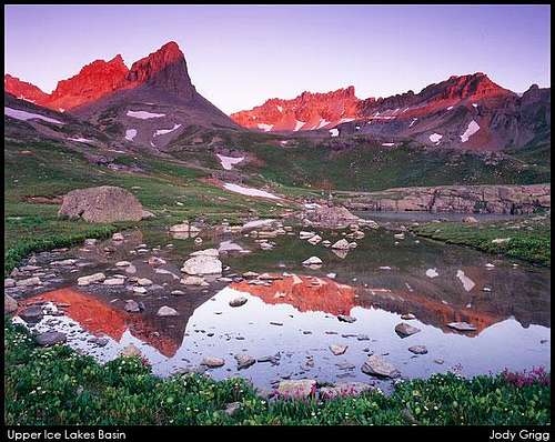 Goldern Horn viewed from Upper Ice Lakes Basin at sunrise early July. Goldern Horn viewed from Upper Ice Lakes Basin at sunrise early July. | 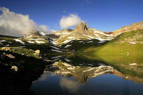 Golden Horn early morning reflection in Ice Lake. July 2005. Golden Horn early morning reflection in Ice Lake. July 2005. | 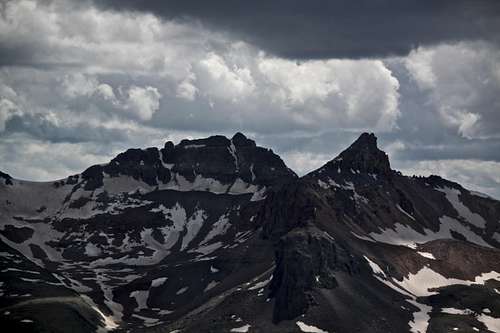 Golden Horn and Vermillion Peaks in Ice Lake Basin as seen from the summit of V2 Golden Horn and Vermillion Peaks in Ice Lake Basin as seen from the summit of V2 |
The area is known for its wildflower supremacy in July. The wildflowers that grace the lower Ice Lake Basin are one of the best. Columbines tower over waist high and delphiniums often brush your face.
Nearby Peaks: Vermilion Peak 0.42 miles away
Fuller Peak 0.64 miles away
Beattie Peak 1 mile away
V 8 1.49 miles away
US Grant 1.67 miles away
Pilot Knob 0.52 miles away
V 3 1.79 miles away
V 4 1.31 miles away
V 2 2 miles away![4 WD road to South Mineral Campground]() Winter South MIneral Creek Road
Winter South MIneral Creek Road![Flowers in Ice lake Basin...]() Flowers in Ice lake Basin near Golden Horn
Flowers in Ice lake Basin near Golden Horn
Getting There
 Winter South MIneral Creek Road
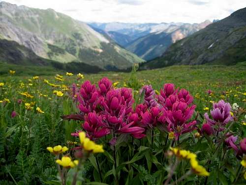 Flowers in Ice lake Basin near Golden Horn
From Silverton take US 550 north for 2.0 miles to the turnoff for the South Mineral Creek Road (FS 585) . Turn left and follow the dirt road for 4.4 miles until you arrive at the South Mineral Creek Campground. There is a parking area at the trailhead with ample spots available.
If approaching from the north, follow US 550 south for 7.8 miles from Red Mountain Pass. Turn right onto South Mineral Creek Road and follow the dirt road for 4.4 miles until you arrive at the South Mineral Creek Campground. There is a parking area at the trailhead with ample spots available.
Per Gerry Roach: High-clearance vehicles can park higher and also shorten the approach. At mile 3.7, turn north (right) onto the Clear Lake Road and climb 1.0 mile northwest to the first switchback at 10,360 feet at mile 4.7. There is limited parking on the switchback’s west side. An unmarked trail starts on the switchback’s west side ad goes west to join the Ice Lake Trail. I use this short cut very often, and would prefer to keep it secret:) you non-frequent visitors can hike the extra distance...
South Mineral Road usually stays open till November (the area is a popular ice climbing destination - see album). It is a nice cross country ski trail later on during the winter. The road typically opens in May/June. If visiting during winter time, always check the avalanche conditions.
Colorado snow pack is dangerous!
Standard Route
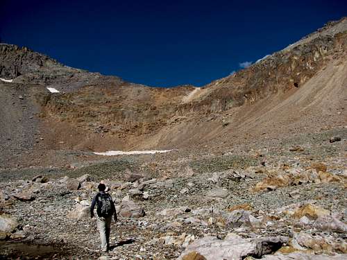
The Southwest Ridge is the standard route up Golden Horn. From the South Mineral Creek Trailhead it is a 10 mile roundtrip with 3,960 feet of elevation gain. The approach starts at the South Mineral Creek Trailhead, elevation 9,840 feet. Follow the well groomed Ice Lake Trail all the way to the Upper Basin. From the trailhead the trail climbs steeply through a long series of switchbacks, reaching Lower Ice Lake Basin at 2.0 miles, elevation 11,400 feet. Stay on the trail to Ice Lake at 3.1 miles, elevation 12,280 feet.From Ice Lake there are several options for reaching the base of the Vermillion-Golden Horn saddle. The standard approach is to follow the trail south from Ice Lake for 0.7 miles towards Fuller Lake. From here, climb a rocky bench west of the lake to 12,900 feet. From here the Vermillion-Golden Horn saddle (=Scarlet Pass) is in view and it is a simple hike through talus to its base at 13,250 feet.
The Scarlet Pass between Vermilion and Golden Horn looks tricky, but it reveals its lines when you actually get there. To reach the saddle head towards the cliffs to the left (south). It is a Class 2+ scramble on loose rock to the saddle at 13,560 feet. There is not a well defined route to the saddle so you will have to search out the best route. It is critical to go to the left at the base of this climb to the saddle to keep the route at Class 2+. Heading to the right side will lead you into cliffs that are at least Class 3 or higher. Mileage at the saddle is 4.6 miles.
 Lower Ice Lake basin with Fuller Peak and Golden Horn peaking in the background. Vermilion is not visible here, it is between those two peaks, but slightly further back. Lower Ice Lake basin with Fuller Peak and Golden Horn peaking in the background. Vermilion is not visible here, it is between those two peaks, but slightly further back. | 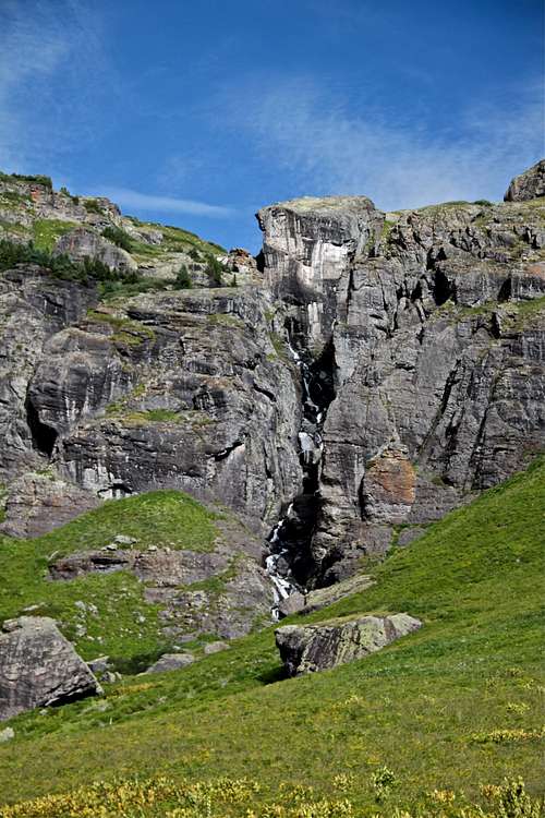 Many waterfalls along the trail into the Ice Lake Basin. Many waterfalls along the trail into the Ice Lake Basin. | 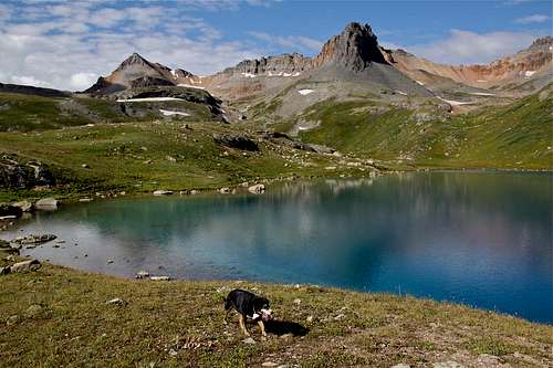 Fuller, Vermilion, and Golden Horn as seen from Ice Lake. Fuller, Vermilion, and Golden Horn as seen from Ice Lake. | 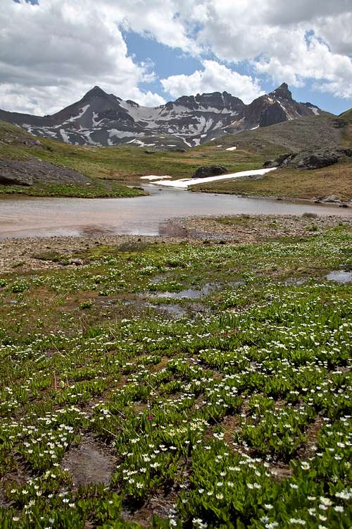 Fuller Peak, Vermillion Peak and Golden Horn as seen from the trail to Island Lake. Fuller Peak, Vermillion Peak and Golden Horn as seen from the trail to Island Lake. |
 Approaching the Vermilion-Golden Horn saddle. Approaching the Vermilion-Golden Horn saddle. | 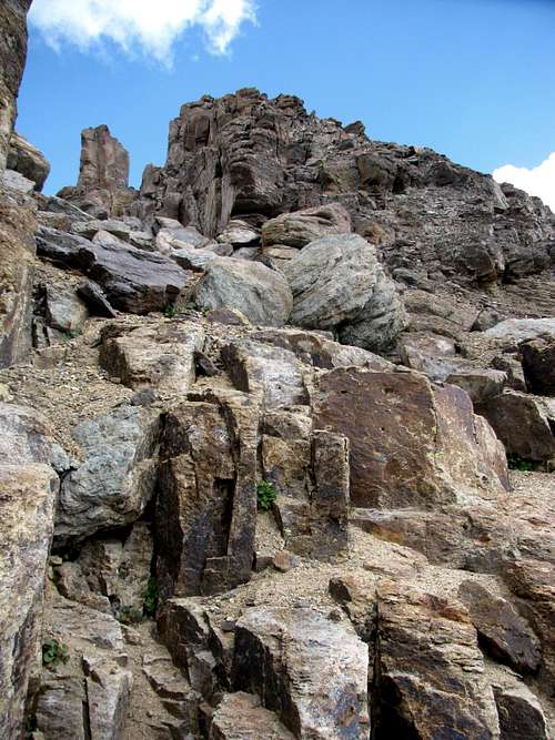 Approaching the summit of Golden Horn. Approaching the summit of Golden Horn. | 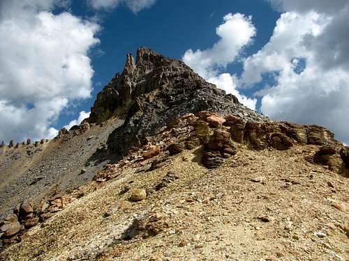 Golden Horn summit ridge Golden Horn summit ridge | 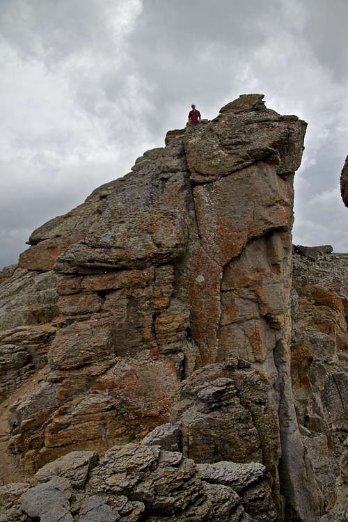 The summit looks dramatic, but technically is very easy. The summit looks dramatic, but technically is very easy. |
If you wish to continue onto Vermilion Peak, you can either scramble from Scarlet Pass = Vermilion-Golden Horn saddle, this would be class 3-4 adventure on a rotten rock. There is a much easier way up Vermillion if you traverse a shelf on the east face of Vermilion Peak, and ascend the standard southeast ridge up to the summit.
Camping
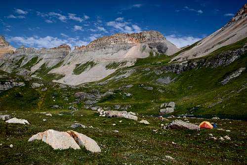 Camping by Ice Lake
Essential Gear
An ice axe may be needed as the basin holds snow late into the summer. It’s never a bad idea to bring a helmet when climbing any of the peaks in the San Juans. From the base of the saddle all the way to the summit there is enough loose rock to warrant bringing a helmet.Resources and External Links
- Trails Illustrated map # 141: Telluride, Silverton, Ouray, Lake City
- Golden Horn on 13ers.com
- Golden Horn on List of John
- Ice Lakes Hike - great informative site
- Wiki page about Silverton