
|
|
Mountain/Rock |
|---|---|
|
|
22.38592°S / 44.61682°W |
|
|
Itatiaia |
|
|
Hiking, Mountaineering, Scrambling |
|
|
Winter |
|
|
8146 ft / 2483 m |
|
|
Cabeça de Leoa Peak (or Female Lion's head peak) belongs to Sierra do Alambari inside Itatiaia National Park. Prohibition is a very common problem within the limits of this park. And just like several other summits inside the park, to reach this summit used to be forbidden. Now they reopened the traverse route and you may get there. You must ask for the permit to go to Maromba Peak and do it with that mountain in a very long day, ask for the permit before and you may not get it. I hate that and of course, I’ll never obey that kind of stupid rules.
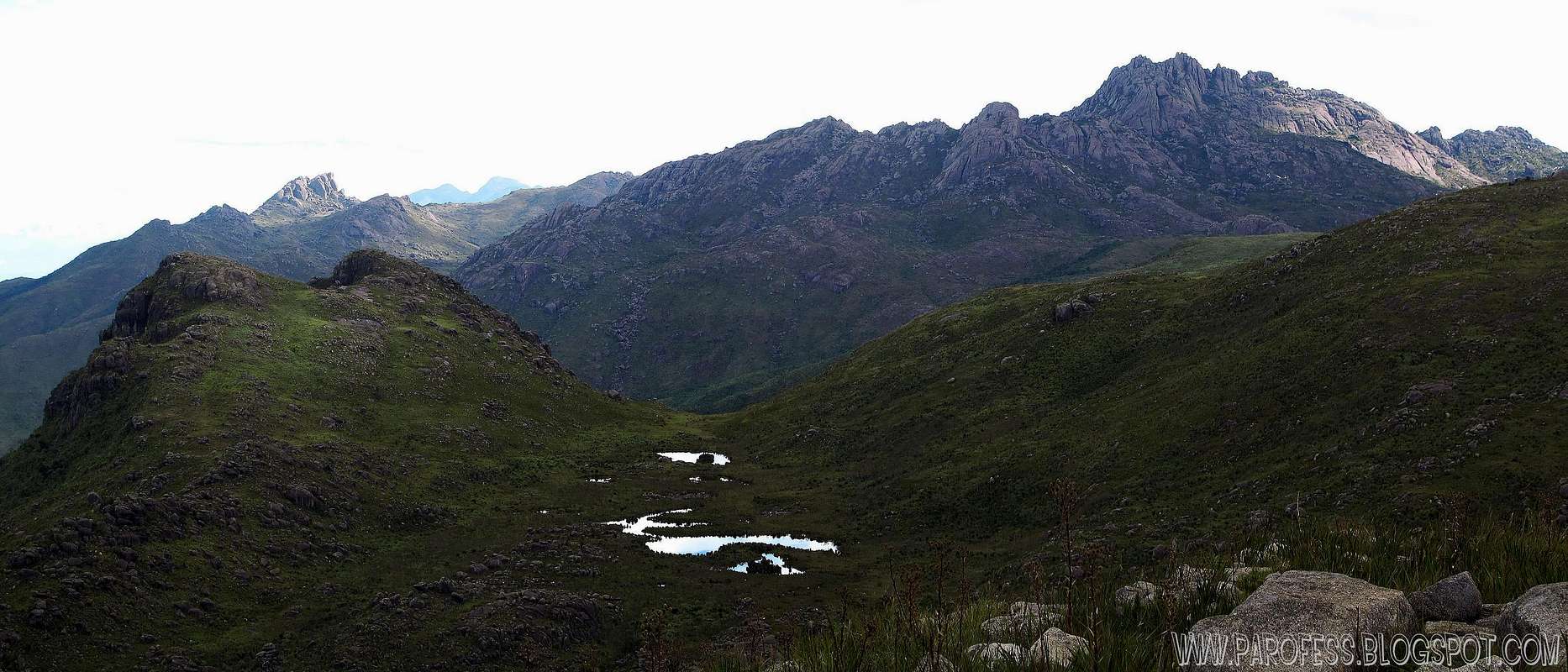
Anyway, it is a huge massive amount of rock and altitude grass mountain with five summits, the highest one is 2.483 meters of altitude. Fantastic views to the west side of Itatiaia National Park, and with that view it is easy to identify several summits such as Urubu Peak, Pedra Assentada, Pico Prateleiras, Agulhas Negras, Asa de Hermes, Unnamed Peak, Pedra do Altar and Pedra do Sino. Some of the highest summits of Brazil.
The peak is located at the east border of the park. The name Cabeça de Leoa is portuguese for "Female lion's head".
![]()
Summit view to the west part of the park, several summits more
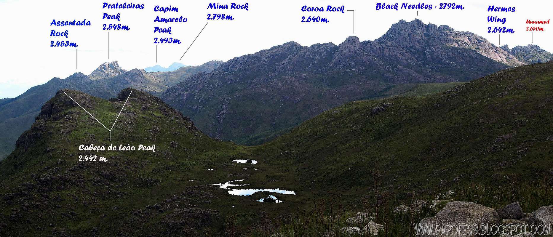
![]()
The same summit view, now with labels
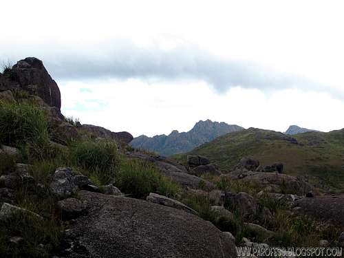
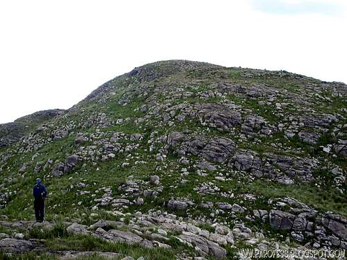
![View during the ascent]()
Hiking up Leoa.
Just like another mountains of the park, you have so many options to reach that distant mountain…
But, depending on your choice, you have to get to different cities outside the limit of the park. If you choose to start the trekking by the east border, go to Visconde de Mauá, at the Escorrega Waterfall (Cachoeira do Escorrega in Portuguese), there is a road at the left side of the waterfall, half an hour walking up you’ll get to a small farm. Ask nicely to the owner to cross his property and show you the trailhead. It is easy and well marked, impossible to get lost. The altitude gain to get to the base of Maromba Peak is around 1.200 meters. It's good to establish a base camp after so many walking and do the summit next morning. You’ll be camped at around 2.280 meters and that means you'll be camped at only a couple hundred meters lower than the summit goal itself, but don't think that will be easy, it's a 12 kms hike to go in and back, and you will have to fight the woods, sometimes higher than you! Water nearby (60 or 70 meters away, that’s it). From there you can do four summits, Maromba Peak, Cabeça de Leão Peak, Cabeça de Leoa Peak and Cara de Gorila Peak.
If you deicide to do it by the west side of the park, you have two choices: Start from the lower part of the park. Go for the city of Itatiaia, there is another entrance of the park there. Ask for the permit to do the Maromba traverse (travessia da maromba in Portuguese). Just follow the “avenue trail” (sometimes the trail is so open that reaches 3 meters wide!) until you get to the base of the mountain. In that case, it’s going to take up to 2 days just to reach the base, and one more to summit the peak and go down at the East side, towards Cachoeira do Escorrega.
The other option to do it by the west side is to get to the well known high entrance of the park, ASK FOR THE PERMIT to do the traverse and take the trail at Rebouças Hut. It is possible to take the Rebouças – Maromba traverse and get to the base of the mountain just like the other option. But this one goes by the left side of Agulhas Negras and Pedra do Sino. The previous option goes by the right of those mountains.
Once you get to the camp, chose your way to the summit, i suggest you take the ridge on Maromba Peak, summit that mountain and go on a straight line towards the mountain. If the weather is good, sometimes you can see up to 200 kms distance! Since that is a distant mountain and the weather changes very fast, sometimes you can find yourself inside a really foggy day so be careful. It's not very easy to reach that summit. Watch out! Also the col between the main ridge of Maromba Peak and the mountain is a nightmare to pass, woods too tall (sometimes 10 ft tall!) and a very wet place, you may find yourself with water up to your knees or maybe higher. Also, be careful with snakes at the area.
![Close to the summit]()
Highest summit ahead of us ![Splattski summit shot]()
Summit Splattski photo![Bivy spot]()
Bivy, easy and light. ![Sat view Cabeça de Leoa Peak]()
Zoom in for details
Several Places you can do that:
Base of Marombinha Peak at 2.280m high;
Summit of Maromba Peak at 2.621m high (no spot for tent just bivy);
South Base of Maromba Peak by the river at 2.320m high;
Base of Gorila Peak at 2.220m high (photo)
Parking lot at the entrance;
Well marked trails (just to camp by Marombinha Peak and Maromba summit);
What’s forbidden:
At all costs, don't make fire or Deforest any places. Respect the nature and wildlife please!
BE CAREFUL ABOUT SNAKES AND POISONOUS SPIDERS (BROWN SPIDER)
A GPS is highly recommended for that part of the park, on a foggy day you will be lost in no time.![]()
PS: The weather forecast on this link is not for this mountain but it will do just fine since the mountain from the forcast (Black Needles) is just a few kms away from it.
To hike/ climb is a dangerous activity and requires proper equipment and clothing, the owner of this page cannot be blamed by injuries caused to anyone who read this page for its info about the mountain, and eventually got hurt by doing so with reckless behaviour or bad weather conditions.
Paulo Roberto Felipe Schmidt – AKA: PAROFES
The biggest brazilian website about climbing and mountaineering, for which I'm a columnist:
Anyway, it is a huge massive amount of rock and altitude grass mountain with five summits, the highest one is 2.483 meters of altitude. Fantastic views to the west side of Itatiaia National Park, and with that view it is easy to identify several summits such as Urubu Peak, Pedra Assentada, Pico Prateleiras, Agulhas Negras, Asa de Hermes, Unnamed Peak, Pedra do Altar and Pedra do Sino. Some of the highest summits of Brazil.
The peak is located at the east border of the park. The name Cabeça de Leoa is portuguese for "Female lion's head".
Getting There
Hiking up Leoa.
Just like another mountains of the park, you have so many options to reach that distant mountain…
But, depending on your choice, you have to get to different cities outside the limit of the park. If you choose to start the trekking by the east border, go to Visconde de Mauá, at the Escorrega Waterfall (Cachoeira do Escorrega in Portuguese), there is a road at the left side of the waterfall, half an hour walking up you’ll get to a small farm. Ask nicely to the owner to cross his property and show you the trailhead. It is easy and well marked, impossible to get lost. The altitude gain to get to the base of Maromba Peak is around 1.200 meters. It's good to establish a base camp after so many walking and do the summit next morning. You’ll be camped at around 2.280 meters and that means you'll be camped at only a couple hundred meters lower than the summit goal itself, but don't think that will be easy, it's a 12 kms hike to go in and back, and you will have to fight the woods, sometimes higher than you! Water nearby (60 or 70 meters away, that’s it). From there you can do four summits, Maromba Peak, Cabeça de Leão Peak, Cabeça de Leoa Peak and Cara de Gorila Peak.
If you deicide to do it by the west side of the park, you have two choices: Start from the lower part of the park. Go for the city of Itatiaia, there is another entrance of the park there. Ask for the permit to do the Maromba traverse (travessia da maromba in Portuguese). Just follow the “avenue trail” (sometimes the trail is so open that reaches 3 meters wide!) until you get to the base of the mountain. In that case, it’s going to take up to 2 days just to reach the base, and one more to summit the peak and go down at the East side, towards Cachoeira do Escorrega.
The other option to do it by the west side is to get to the well known high entrance of the park, ASK FOR THE PERMIT to do the traverse and take the trail at Rebouças Hut. It is possible to take the Rebouças – Maromba traverse and get to the base of the mountain just like the other option. But this one goes by the left side of Agulhas Negras and Pedra do Sino. The previous option goes by the right of those mountains.
Once you get to the camp, chose your way to the summit, i suggest you take the ridge on Maromba Peak, summit that mountain and go on a straight line towards the mountain. If the weather is good, sometimes you can see up to 200 kms distance! Since that is a distant mountain and the weather changes very fast, sometimes you can find yourself inside a really foggy day so be careful. It's not very easy to reach that summit. Watch out! Also the col between the main ridge of Maromba Peak and the mountain is a nightmare to pass, woods too tall (sometimes 10 ft tall!) and a very wet place, you may find yourself with water up to your knees or maybe higher. Also, be careful with snakes at the area.
Highest summit ahead of us
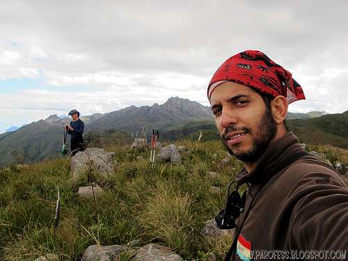
Summit Splattski photo
Camping

Bivy, easy and light.

Zoom in for details
Several Places you can do that:
Base of Marombinha Peak at 2.280m high;
Summit of Maromba Peak at 2.621m high (no spot for tent just bivy);
South Base of Maromba Peak by the river at 2.320m high;
Base of Gorila Peak at 2.220m high (photo)
Red Tape
If you go by the high entrance of the park, as soon as you get there register yourself and pay a fee of R$ 12,00 (about USD 7.00) for the entrance.Parking lot at the entrance;
Well marked trails (just to camp by Marombinha Peak and Maromba summit);
What’s forbidden:
At all costs, don't make fire or Deforest any places. Respect the nature and wildlife please!
BE CAREFUL ABOUT SNAKES AND POISONOUS SPIDERS (BROWN SPIDER)
A GPS is highly recommended for that part of the park, on a foggy day you will be lost in no time.
Weather forecast
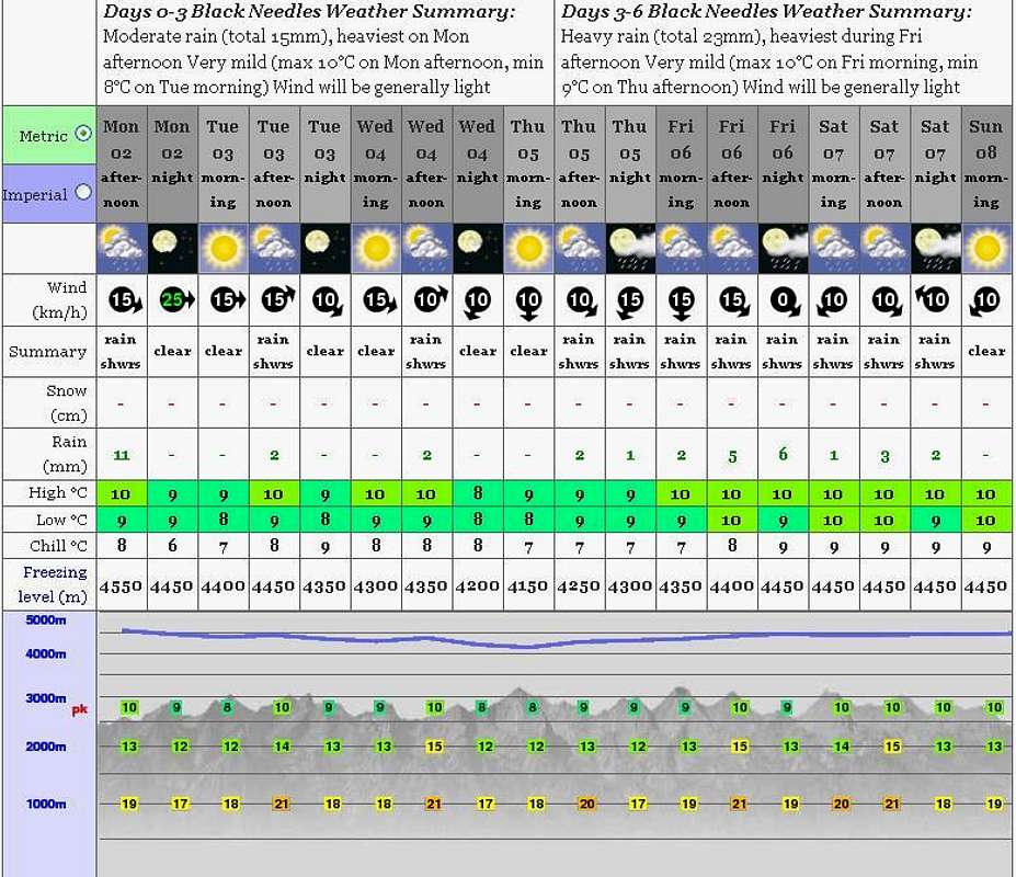
PS: The weather forecast on this link is not for this mountain but it will do just fine since the mountain from the forcast (Black Needles) is just a few kms away from it.
Legal Issues
To hike/ climb is a dangerous activity and requires proper equipment and clothing, the owner of this page cannot be blamed by injuries caused to anyone who read this page for its info about the mountain, and eventually got hurt by doing so with reckless behaviour or bad weather conditions.
Paulo Roberto Felipe Schmidt – AKA: PAROFES
External Links
My youtube channel: www.youtube.com/parofes - Now with 270+ videos online!The biggest brazilian website about climbing and mountaineering, for which I'm a columnist: