
|
|
Mountain/Rock |
|---|---|
|
|
38.54686°N / 114.45363°W |
|
|
Lincoln |
|
|
Hiking |
|
|
Spring, Summer, Fall, Winter |
|
|
8435 ft / 2571 m |
|
|
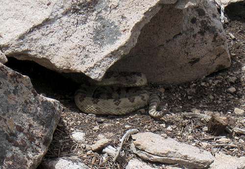
almost stepped on this guy
Overview
If you are looking for isolation and the chance to have no one else in the area you are heading into, this area is just perfect for you. Many of the peaks in Nevada are isolated and not close to anything but this one will not disappoint if that is what you are looking for. Very few people over the past 18 years have visited the summit of this range and perhaps for good reason. It isn't an attractive peak, it has no easy access and unless you are a peakbagger interested in range highpoints or prominence, there is little to attract you. It is near the bottom of the list as far as Nevada prominence peaks are concerned with just barely qualifying with the required 2000 feet of prominence. See this list of john listing for more information (link).In researching out a route for this range, I was fortunate enough to have a fellow SP member make a visit only a month or so before I visited and it was he who provided the key that made our route work. Thanks gregiels (Greg), your beta was spot on and we found that the key was actually finding the jeep track that led us close to Basin Spring from the east side. For the very few of you who might be interested, I will share this on the route section.
Getting There
From Ely head south on US 50/6 to Majors Place. Go south toward Pioche and drive about 20 miles on US 93. Watch for a signed turnoff for Atlanta (not the one in Georgia) and turn east onto this road. This is a good graded road that I found to be relatively high speed (you know, 40 or so). Head south for 16.5 miles, always taking the obvious main road despite several roads that come in from other directions. At a fenceline, just over a cattle grate (Gps38.59145 114.35312) elev 6065, turn right and follow the road west for a mile and a half until you come to a road that comes in from the north and has a gate on the north side of the road. Turn south here and drive the road another 3.8 miles but it is best to have the waypoint 6301 on your GPS as the road you are looking for is very faint and easy to miss. We drove past it the first time and had it not been for Greg's month old tracks, we might have missed it the second time. You could park off the road here and walk the rest of the way in since the faint track is rough and a paint scratcher in places. It save you only a mile anyway so if you do miss it, the GPS coordinate I have placed on the map will put you close to it. (see the route map)
 Northern part of range Northern part of range |  BLM road sign BLM road sign |  Heading for our mountain Heading for our mountain |
 Map 1 Map 1 |  Middle part of range Middle part of range |  Map 2 Map 2 |
peakbagger.com to get more information on this.
Red Tape
All the area is BLM land so there aren't any restrictions until you reach close to Basin Spring. Then it becomes a wilderness study area (we stumbled across one of the BLM markers but it wasn't obvious).BLM Ely District Office
702 N. Industrial Way
HC 33 Box 33500
Ely NV 89301
Phone: 775-289-1800
Office Hours: 7:30 am - 4:30 pm M-F
Caliente Field Office
US Highway 93, Building #1
P.O. Box 237
Caliente NV 89008
Phone: 775-726-8100
Office Hours: 7:30 am - 4:15 pm M-F
Camping and weather
No organized campgrounds in the area but for those seeking a campground, Cathedral Gorge is a nice one (has showers) just a few miles south of Pioche. Car camping appears to be no problem if you will follow the leave no trace ethic. Otherwise there are motels and services available in Ely or more campgrounds available at Great Basin National Park.
Click for weather forecast

Click for weather forecast
Summit stuff
Very few make it to this summit. Since 1994 the list reads like this:1994 Gordon Macleod & Barbara Lilley
2001 Alvin McLain and friend
2002 Tom Roundtree
2005 John Vitz and Andy Martin
2012 Greg Jagielski
2012 Ken Jones and Dean Molen
2013-2015 8 more have been to this one including 4 of the 6 in 2014 alone.
 Register page Register page |  Register page Register page |  Register page Register page |
 Summit area Summit area |  Ken signs in Ken signs in |  Ken near top Ken near top |
Route

Route page
From where we parked our vehicle, we made our way through the scrub trees and vegetation, making use of the washes we could find to ease our way up the range. We got onto a ridgeline that worked its way north and then curved to the southwest and we found horse trails that we followed most of the way, even right up to the highest point. A bit of snow remained in spots from the storm of the previous day but this range can be very hot in the summer and so it might be best to consider it for any season but the hot summer season or the rainy season (whenever that happens). Overall for us, we clocked in almost five miles roundtrip and almost 2000 feet of gain. The views from the summit were nice to the north, west and south but limited by the trees to the east.
Ken Jones has posted a GPS track of our route HERE.
 Mt. Grafton to the NW Mt. Grafton to the NW |  Looking north Looking north |  West to Dutch John West to Dutch John |